North Greenbush, New York

Last updated

North Greenbush
Town of North Greenbush
Etymology: From being the northern half of the old town of Greenbush;
Greenbush from the Dutch Greenen Bosch, meaning "pinewood" for the pine forests of the area
Rensselaer County New York incorporated and unincorporated areas North Greenbush highlighted.svg
Location in Rensselaer County and the state of New York.
New York in United States (US48).svg
Location of New York in the United States
Coordinates: 42°40′30″N73°39′29″W / 42.67500°N 73.65806°W / 42.67500; -73.65806
CountryUnited States
State New York
County Rensselaer
Incorporation as town 1855
Area
[1]
  Total18.91 sq mi (48.97 km2)
  Land18.55 sq mi (48.03 km2)
  Water0.36 sq mi (0.94 km2)
Elevation
531 ft (162 m)
Lowest elevation
0 ft (0 m)
Population
 (2020)
  Total13,929
  Density737/sq mi (284/km2)
Time zone UTC−5 (EST)
  Summer (DST) UTC−4 (EDT)
ZIP code
12198, 12180, 12144
Area codes 518, 838
FIPS code 36-083-52100
FIPS code 36-52100 [2]
GNIS feature ID0979287 [3]
Wikimedia CommonsNorth Greenbush, New York
Website www.townofng.com

North Greenbush is a town in Rensselaer County, New York, United States. North Greenbush is located in the western part of the county. The population was 13,292 at the 2020 census.

Contents

The town has three main hamlets, Wynantskill in the northeastern corner, Defreestville in the southern portion of the town, and Snyder's Lake which occupies the majority of the town's eastern end. Each have strong identities and hinder efforts by the town to have a centralized identity. [4] Also hindering a unified town image is that North Greenbush consists of parts of four different school districts, only one of which (a one-room schoolhouse) carries the town's name; two fire departments (Wynantskill and Defreestville); and three ZIP codes (City of Troy, City of Rensselaer, and Wynantskill). [4] North Greenbush is home to the southern part of the Hudson Valley Community College (HVCC) campus, including the Joseph L. Bruno Stadium, home to the Tri-City ValleyCats minor league baseball team; the RPI Tech Park; the La Salle Institute; the New York State National Guard Armory, headquarters for the Rainbow Division; and various Rensselaer County government institutions. [4]

History

North Greenbush was part of the Manor of Rensselaerswyck, and Albany County prior to Rensselaer County's creation in 1791. North Greenbush was created on February 23, 1855, from the town of Greenbush at the same time as the town of Clinton (today East Greenbush). At this time, North Greenbush occupied more than what it does today; it also covered what is now the northern section of the city of Rensselaer and the southern section of the city of Troy.

The earliest settlers, in the early 1620s settled in Bath, a part of the town annexed to Rensselaer in 1902. Some settlement in what is today North Greenbush may have taken place in the 17th century as well, but most significant early settlement occurred just prior to the Revolutionary War. Early settlements in the town were at Bath, Wynantskill, and Defreestville. In 1874 Bath became incorporated as a village, and in 1902 it was annexed to Rensselaer. Wynantskill, in the northeastern corner of the town, was first settled around the end of the 18th century with a Dutch Reformed Church established circa 1794, and a post office was established in 1820. [5] Defreestville was originally called Blooming Grove until approximately 1830, when it was changed due to confusion with another Blooming Grove, in Orange County, [6] it was named Defreestville for David M. De Freest and family who owned a tavern there. [5] Defreestville and Wynantskill continue to be important hamlets in the town. Snyders Lake would, in the 20th century, also become an important community. [6] Snyders Lake was developed as summer residences and continues to lack a central business district. [4]

During the 20th century, North Greenbush would begin to see more development due to an improved transportation infrastructure which led to increased suburban residential, office, and retail growth based on the automobile. In 1931, the road between Troy and East Greenbush was widened and the right-of-way straightened as US Route 4. The older, narrower, winding residential parts of the road were bypassed and is today's Bloomingrove Drive. [6] Starting in the 1940s and 1950s, suburban growth along Route 4 would begin to displace farms and local businesses with national chains with an automobile oriented pattern of growth. [4] This suburban growth would be encouraged by the construction of Interstate 90 (I-90) and the Patroon Island Bridge in the 1960s, making North Greenbush an easy commute to Albany. [6] I-90 would not have a direct exit to North Greenbush until 1996 though, when Exit 8 was constructed connecting US 4 and NY Route 43 to the interstate. [4] In the 1970s Rensselaer Polytechnic Institute (RPI) began developing the RPI Tech Park on Route 4 as a business incubator, today it has over 1,000,000 square feet (93,000 m2) of office space. [4] A connector highway will eventually also go from Exit 8 parallel to US 4 north through the RPI Tech Park and meet US 4 near Hudson Valley Community College (HVCC) at the Troy city line. [4]

Not all suburban growth has been well received in the town, however. In the late 1990s, the RPI Tech Park became the focus of regional and statewide push to get a chip fabrication factory (chip fab plant) built. The RPI Tech Park site originally met little opposition from the town. [7] But as time progressed, opposition grew in response to concerns about potential impacts on traffic and the environment. [8] The RPI Tech Park site, which by October 1999 had become one of only nine sites still being marketed by the state, was terminated when the North Greenbush town council voted to terminate the review process. [9] Another instance of NIMBY opposition to development occurred after the construction of I-90's Exit 8 when that location became well-primed for commercial development. Local developer Frank Nigro, with Nigro Company, proposed a high-end shopping center for the northeastern corner of the intersection of routes 4 and 43. This led to lawsuits and a failed push by residents of Defreestville to incorporate as a village in order to stop the development; and a counter-move by the developer and certain landowners to attempt annexation to the neighboring city of Rensselaer where the development would be better received. [10]

The Defreest Homestead was listed on the National Register of Historic Places in 1977. [11]

Geography

According to the United States Census Bureau, the town has a total area of 19.0 square miles (49 km2), of which 18.7 square miles (48 km2) is land and 0.3 square miles (0.78 km2) (1.74%) is water. The western section of the town is steeply sloped and cut by various ravines; the clay bluffs rise between 100 and 200 feet (61 m) above the river with little to no flood plain. [12] The central and eastern parts consist of more gently rolling hills and valleys. The Hudson River is the river of the town, though it is inaccessible to the public at this time; [4] the Wynants Kill in the northeastern section is a creek of some respectable size. Snyder's Lake near the eastern border is the largest lake in the town and is accessible to the public.

The west town line is marked by the Hudson River with Albany County on the opposite shore. The city of Albany shares a brief common border with the town, the rest of the western boundary in the Hudson River is shared with the village of Menands within the town of Colonie. To the north is Troy and the town of Brunswick with the towns of Poestenkill and Sand Lake to the east. Most of the southern border is shared with East Greenbush, while the city of Rensselaer's northern section is partially surrounded by North Greenbush in the town's southwestern corner.

Location

Demographics

Historical population
CensusPop.Note
1860 2,170
1870 3,05840.9%
1880 4,13135.1%
1890 4,76815.4%
1900 4,719−1.0%
1910 1,293−72.6%
1920 1,42510.2%
1930 2,21555.4%
1940 3,22345.5%
1950 4,91352.4%
1960 8,16166.1%
1970 10,51328.8%
1980 10,396−1.1%
1990 10,8914.8%
2000 10,805−0.8%
2010 12,07511.8%
2020 13,92915.4%
U.S. Decennial Census [13]

As of the census [2] of 2000, there were 10,805 people, 4,161 households, and 2,916 families residing in the town. The population density was 578.0 inhabitants per square mile (223.2/km2). There were 4,336 housing units at an average density of 232.0 per square mile (89.6/km2). The racial makeup of the town was 96.81% White, 1.01% African American, 0.09% Native American, 0.76% Asian, 0.01% Pacific Islander, 0.24% from other races, and 1.08% from two or more races. Hispanic or Latino of any race were 0.85% of the population.

There were 4,161 households, out of which 30.0% had children under the age of 18 living with them, 57.5% were married couples living together, 9.0% had a female householder with no husband present, and 29.9% were non-families. 25.2% of all households were made up of individuals, and 11.9% had someone living alone who was 65 years of age or older. The average household size was 2.47 and the average family size was 2.97.

In the town, the age distribution of the population shows 22.6% under the age of 18, 5.8% from 18 to 24, 27.7% from 25 to 44, 25.0% from 45 to 64, and 18.8% who were 65 years of age or older. The median age was 41 years. For every 100 females, there were 89.7 males. For every 100 females age 18 and over, there were 86.9 males.

The median income for a household in the town was $82,227, and the median income for a family was $62,845. Males had a median income of $40,872 versus $29,743 for females. The per capita income for the town was $24,025. About 2.0% of families and 3.0% of the population were below the poverty line, including 3.0% of those under age 18 and 2.5% of those age 65 or over.

Notable person

Communities and locations in North Greenbush

Related Research Articles

<span class="mw-page-title-main">Rensselaer County, New York</span> County in New York, United States

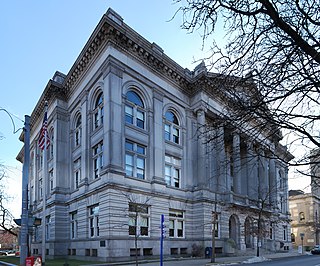
Rensselaer County is a county in the U.S. state of New York. As of the 2020 census, the population was 161,130. Its county seat is Troy. The county is named in honor of the family of Kiliaen van Rensselaer, the original Dutch owner of the land in the area. The county is part of the Capital District region of the state.

<span class="mw-page-title-main">Berlin, New York</span> Town in New York, United States

Berlin is a town in Rensselaer County, New York, United States. The population was 1,808 at the 2020 census. The town is named after Berlin in Germany, although natives pronounce the name differently, with the accent on the first syllable.

<span class="mw-page-title-main">Hoosick, New York</span> Town in New York, United States

Hoosick is a town in Rensselaer County, New York, United States. The population was 6,711 at the 2020 census. It was named from the Hoosic River.

<span class="mw-page-title-main">Rensselaer, New York</span> City in Rensselaer County, New York, US

Rensselaer is a city in Rensselaer County, New York, United States, and is located on the east side of the Hudson River, opposite Albany and on the western border of Rensselaer County. As of the 2020 census, the city population was 9,210.

<span class="mw-page-title-main">Sand Lake, New York</span> Town in New York, United States

Sand Lake is a town in south-central part of Rensselaer County, New York, United States. Sand Lake is about 13 miles east of Albany, New York. As of the 2020 census, the population was 8,348. Within the town are three hamlets: Averill Park, Glass Lake and the hamlet of Sand Lake. Its four lakes are a source of recreation. Many commercial enterprises of the 19th century and into the 20th century relied on power generated from the Wynants Kill Creek and Burden Lake mills. The area is known for its fertile soil for grazing and agriculture.

<span class="mw-page-title-main">Schodack, New York</span> Town in New York, United States

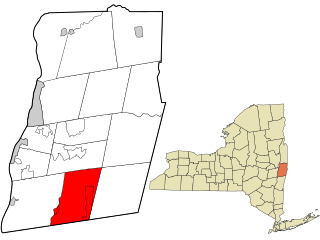
Schodack is a town in Rensselaer County, New York, United States. The population was 12,965 at the 2020 census. The town name is derived from the Mahican word, Escotak. The town is in the southwestern part of the county. Schodack is southeast of Albany, New York.

<span class="mw-page-title-main">Malta, New York</span> Town in New York, United States

Malta is a town in Saratoga County, New York, United States. The town is in the central part of the county and is south of Saratoga Springs. The population was 17,130 as of the 2020 census.

<span class="mw-page-title-main">East Greenbush, New York</span> Town in New York, United States

East Greenbush is a town in Rensselaer County, New York, United States. It is a suburb of Albany. The population was 16,748 at the 2020 census. The word Greenbush is derived from the Dutch het groen bosch, referring to the pine woods that originally covered the land. The first settlement of the land now known as East Greenbush was made by tenants under patroon Kiliaen van Rensselaer circa 1630. The town was established in 1855 as Clinton, and was renamed in 1858. It is mostly suburban along its major highways and rural in the southwestern and northeastern corners.

<span class="mw-page-title-main">Nassau, New York</span> Town in Rensselaer County, New York, US

Nassau is a town in Rensselaer County, New York, United States. The population was 4,545 in 2020, down from 4,789 at the 2010 census.

<span class="mw-page-title-main">Capital District (New York)</span> Region in New York, United States

The Capital District, also known as the Capital Region, is the metropolitan area surrounding Albany, the capital of the U.S. state of New York. The Capital District was first settled by the Dutch in the early 17th century and came under English control in 1664. Albany has been the permanent capital of the state of New York since 1797. The Capital District is notable for many historical events that predate the independence of the United States, including the Albany Plan of Union and the Battles of Saratoga.

John Evert Van Alen was an American surveyor, merchant, and politician from the U.S. state of New York. He served as a Federalist member of the United States House of Representatives.

<span class="mw-page-title-main">New York State Route 151</span> State highway in Rensselaer County, New York, US

New York State Route 151 (NY 151) is an 8.23-mile (13.24 km) state highway located in Rensselaer County, New York, in the United States. Its western terminus is at an interchange with the U.S. Route 9 (US 9) and US 20 in Rensselaer, and its eastern terminus is at a junction with NY 150 in Shivers Corners, a hamlet in the town of Schodack. It also has an intersection with US 4 in East Greenbush. NY 151 was assigned to most of its current alignment as part of the 1930 renumbering of state highways in New York. In Rensselaer, NY 151 has been altered several times, with the most recent change coming in the late 1990s. The current western terminus of NY 151 was once the western terminus of NY 43.

<span class="mw-page-title-main">New York State Route 43</span> State highway in Rensselaer County, New York, US

New York State Route 43 (NY 43) is a state highway in Rensselaer County, New York, in the United States. It extends for 24.00 miles (38.62 km) from Interstate 90 (I-90) exit 8 in North Greenbush to the Massachusetts state line, where it continues into Williamstown as Massachusetts Route 43. Most of NY 43 is a two-lane highway that passes through a mixture of rural and residential areas; however, its westernmost 2 miles (3.2 km) between I-90 and U.S. Route 4 (US 4) is a four-lane divided highway. NY 43 has an overlap with NY 66 in Sand Lake and intersects NY 22 in Stephentown.

<span class="mw-page-title-main">New York State Route 66</span> State highway in New York, US

New York State Route 66 (NY 66) is a state highway in the Capital District of New York in the United States. The route begins at an intersection with US 9 and NY 23B in the Columbia County city of Hudson and ends at a junction with NY 2 in the Rensselaer County city of Troy. While both Hudson and Troy are located on the Hudson River, NY 66 follows a more inland routing between the two locations to serve several rural villages and hamlets, including Chatham and Sand Lake. NY 66 overlaps with U.S. Route 20 (US 20) and NY 43, two regionally important east–west highways, in Nassau and Sand Lake, respectively.

<span class="mw-page-title-main">New York State Route 136</span> State highway in Rensselaer County, New York, US

New York State Route 136 (NY 136) is a state highway within the town of North Greenbush in Rensselaer County, New York, in the United States. It begins at an intersection with U.S. Route 4 (US 4) just south of Troy and ends at a junction with NY 150 in the hamlet of Wynantskill. NY 136 provides access to Hudson Valley Community College, located in an otherwise residential area of suburban Troy. The route was assigned in the late 1930s as a connector between US 4 and Winter Street, then part of NY 40. NY 136 was extended to its current length in 1980.

<span class="mw-page-title-main">New York State Route 150</span> State highway in Rensselaer County, New York, US

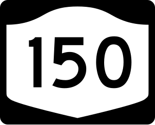
New York State Route 150 (NY 150) is a north–south state highway in Rensselaer County, New York, in the United States. The southern terminus of the route is at NY 9J in Castleton-on-Hudson. Its northern terminus is at a junction with NY 66 in the hamlet of Wynantskill, located within the town of North Greenbush.

<span class="mw-page-title-main">New York State Route 152</span> Former state highway in New York State

New York State Route 152 (NY 152) was a 6.0-mile-long (9.7 km) east–west state highway in Rensselaer County, New York, in the United States. The western terminus of the route was at an intersection with U.S. Route 4 (US 4) and NY 43 in the town of North Greenbush. Its eastern terminus was at a junction with NY 150 in the town of Sand Lake. NY 152 was little more than a connector between the hamlets of Defreestville and Sliters.

<span class="mw-page-title-main">Tech Valley</span> Region in New York, United States

Tech Valley began as a marketing name for the eastern part of the U.S. state of New York, encompassing the Capital District and the Hudson Valley. Originating in 1998 to promote the greater Albany area as a high-tech competitor to regions such as Silicon Valley and Boston, the moniker subsequently grew to represent the counties in New York between IBM's Westchester County plants in the south and the Canada–United States border to the north, and has since evolved to constitute both the technologically oriented metonym and the geographic territory comprising most of New York State north of New York City. The area's high technology ecosystem is supported by technologically focused academic institutions including Rensselaer Polytechnic Institute and the State University of New York Polytechnic Institute.

<span class="mw-page-title-main">Craver Farmstead</span> Historic house in New York, United States

The Craver Farmstead was established circa 1790 consisting of 225 acres with a farmhouse and a barn. Today, the Craver Farmstead is both architecturally and historically significant. The farmhouse was built prior to 1790 and stands as one of the oldest and best preserved examples of Federal-style architecture in upstate New York. The Federal style evolved as the dominant classicizing architecture in North America between 1780 and 1830 as the new republic of the United States sought to define itself as independent in literature, art, and architecture just as it was politically.

<span class="mw-page-title-main">Snyder's Lake, New York</span> Hamlet in New York, United States

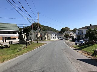
Snyder's Lake is a hamlet of North Greenbush in Rensselaer County, New York, United States.

References

  1. "2016 U.S. Gazetteer Files". United States Census Bureau. Retrieved July 5, 2017.
  2. 1 2 "U.S. Census website". United States Census Bureau . Retrieved January 31, 2008.
  3. "US Board on Geographic Names". United States Geological Survey. October 25, 2007. Retrieved January 31, 2008.
  4. 1 2 3 4 5 6 7 8 9 Laberge Group (June 2009). "North Greenbush Comprehensive Plan". Town of North Greenbush. Retrieved January 28, 2010.
  5. 1 2 George Baker Anderson (1897). "History of North Greenbush". D. Mason & Co. Retrieved January 26, 2010.
  6. 1 2 3 4 Karen Hartgen and Sam Swanson. "Town History". Town of North Greenbush. Retrieved January 26, 2010.
  7. Laura Lee (June 12, 1998). "Review of chip plan on track". Albany Times Union. Retrieved September 29, 2009.
  8. Michele Morgan Bolton (March 5, 1999). "Public sees two sides to chip plant". Albany Times Union. Retrieved September 29, 2009.
  9. Michele Morgan Bolton (October 15, 1999). "Board rejects chip plants". Albany Times Union. Retrieved September 29, 2009.
  10. Kate Perry (July 6, 2006). "Court allows plaza project". Albany Times Union. Archived from the original on January 15, 2010. Retrieved January 28, 2010.
  11. 1 2 "National Register Information System". National Register of Historic Places . National Park Service. July 9, 2010.
  12. J.H. French (1860). Gazetteer of the State of New York. R. Pearsall Smith. p.  557 . Retrieved January 28, 2010. new york gazetteer 1860.
  13. "Census of Population and Housing". Census.gov. Retrieved June 4, 2015.
  14. "VAN ALEN, John Evert, (1749 - 1807)". Biographical Directory of the United States Congress. Retrieved July 31, 2014.
  15. University of the State of New York Bulletin. University of the State of New York. 1914. p. 51.

Further reading