Poestenkill (CDP), New York

Last updated
Poestenkill, New York
CDP
Rensselaer County New York incorporated and unincorporated areas Poestenkill (CDP) highlighted.svg
Location in Rensselaer County and the state of New York.
USA New York location map.svg
Red pog.svg
Poestenkill, New York
Location within the state of New York
Coordinates: 42°41′45″N73°33′50″W / 42.69583°N 73.56389°W / 42.69583; -73.56389 Coordinates: 42°41′45″N73°33′50″W / 42.69583°N 73.56389°W / 42.69583; -73.56389
Country United States
State New York
County Rensselaer
Area
[1]
  Total5.94 sq mi (15.39 km2)
  Land5.88 sq mi (15.22 km2)
  Water0.07 sq mi (0.17 km2)
Elevation
479 ft (146 m)
Population
 (2020)
  Total1,020
  Density173.59/sq mi (67.02/km2)
Time zone UTC-5 (Eastern (EST))
  Summer (DST) UTC-4 (EDT)
ZIP code
12140
Area code 518
FIPS code 36-58794
GNIS feature ID0960804

Poestenkill is a hamlet (and census-designated place) in Rensselaer County, New York, United States. The population was 1,061 at the 2010 census. The name is taken from Poesten Kill, a stream in the area.

Contents

Poestenkill is in the southern part of the Town of Poestenkill.

Geography

Poestenkill is located at 42°41′44″N73°33′50″W / 42.69556°N 73.56389°W / 42.69556; -73.56389 (42.695815, -73.563912). [2]

The Poesten Kill flows past the community.

According to the United States Census Bureau, the CDP has a total area of 5.9 square miles (15.2 km2), of which 5.8 square miles (15.1 km2) is land and 0.04 square mile (0.1 km2) (0.68%) is water.

Poestenkill Poestenkill, NY RT 351.JPG
Poestenkill

Demographics

Historical population
CensusPop.
2020 1,020
U.S. Decennial Census [3]

As of the census [4] of 2000, there were 1,024 people, 396 households, and 291 families residing in the CDP. The population density was 175.4 per square mile (67.7/km2). There were 426 housing units at an average density of 73.0/sq mi (28.2/km2). The racial makeup of the CDP was 98.54% White, 0.10% Native American, 0.29% Asian, 0.39% from other races, and 0.68% from two or more races. Hispanic or Latino of any race were 0.68% of the population.

There were 396 households, out of which 35.4% had children under the age of 18 living with them, 60.9% were married couples living together, 10.1% had a female householder with no husband present, and 26.3% were non-families. 21.5% of all households were made up of individuals, and 10.6% had someone living alone who was 65 years of age or older. The average household size was 2.59 and the average family size was 3.02.

In the CDP, the population was spread out, with 25.6% under the age of 18, 6.2% from 18 to 24, 29.1% from 25 to 44, 26.9% from 45 to 64, and 12.3% who were 65 years of age or older. The median age was 39 years. For every 100 females, there were 97.3 males. For every 100 females age 18 and over, there were 94.9 males.

The median income for a household in the CDP was $54,219, and the median income for a family was $62,885. Males had a median income of $37,857 versus $30,726 for females. The per capita income for the CDP was $21,946. None of the families and 1.2% of the population were living below the poverty line, including no under eighteens and 3.5% of those over 64.

Related Research Articles

<span class="mw-page-title-main">Central, Alaska</span> CDP in Alaska, United States

Central is a census-designated place (CDP) in Yukon-Koyukuk Census Area, Alaska, United States. At the 2010 census the population was 96, down from 134 in 2000. Every February, Central hosts a checkpoint for the long-distance Yukon Quest sled dog race.

Four Mile Road is a census-designated place (CDP) in Yukon-Koyukuk Census Area, Alaska, United States. The population was 43 at the 2010 census, up from 38 in 2000.

<span class="mw-page-title-main">Paisley, Florida</span> Census-designated place in Florida

Paisley is an unincorporated community and census-designated place (CDP) in Lake County, Florida, United States. The population was 818 at the 2010 census, up from 734 at the 2000 census. It is part of the Orlando–Kissimmee Metropolitan Statistical Area.

Stacyville is a town in Penobscot County, Maine, United States, in the foothills of Mount Katahdin. The population was 380 at the 2020 census.

<span class="mw-page-title-main">Middletown, Michigan</span> Census-designated place & unincorporated community in Michigan, United States

Middletown is an unincorporated community and census-designated place (CDP) in Shiawassee County in the U.S. state of Michigan. The CDP had a population of 897 at the 2010 census. Middletown is located within Caledonia Township along M-71 between the cities of Corunna and Owosso

<span class="mw-page-title-main">Holiday City South, New Jersey</span> Census-designated place in New Jersey, United States

Holiday City South is an unincorporated community and census-designated place (CDP) located within Berkeley Township, in Ocean County, New Jersey, United States. As of the 2010 United States Census, the CDP's population was 3,689.

Melrose Park is a suburban community and census-designated place (CDP) in Cayuga County, New York, United States. The population was 2,294 at the 2010 census. It is a suburb of Auburn, located south of the city in the town of Owasco.

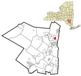
Jefferson Heights is a hamlet and census-designated place (CDP) in Greene County, New York, United States. The population was 1,094 at the 2010 census.

<span class="mw-page-title-main">Lake Katrine, New York</span> CDP in New York, United States

Lake Katrine is a hamlet in Ulster County, New York, United States. The population was 2,397 at the 2010 census.

Stony Point is a census-designated place (CDP) in Sequoyah County, Oklahoma, United States. It is part of the Fort Smith, Arkansas-Oklahoma Metropolitan Statistical Area. The population was 177 at the 2000 census.

<span class="mw-page-title-main">Republic, Pennsylvania</span> Census-designated place in Pennsylvania, United States

Republic is an unincorporated community and census-designated place (CDP) in Fayette County, Pennsylvania, United States. The population was 1,096 at the 2010 census, down from 1,396 at the 2000 census. The community is in Redstone Township.

<span class="mw-page-title-main">Spring Garden-Terra Verde, Texas</span> Former CDP in Texas, United States

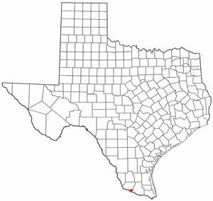
Spring Garden-Terra Verde is a census-designated place (CDP) in Nueces County, Texas, United States. The population was 693 at the 2000 census.

<span class="mw-page-title-main">West Alto Bonito, Texas</span> CDP in Texas, United States

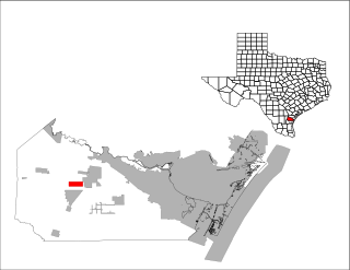
West Alto Bonito is a census-designated place (CDP) in Starr County, Texas, United States. The population was 696 in 2010 census. Prior to the 2010 census West Alto Bonito CDP was known as Alto Bonito CDP.

<span class="mw-page-title-main">Lake Marcel-Stillwater, Washington</span> Census-designated place in Washington, United States

Lake Marcel-Stillwater is a census-designated place (CDP) in King County, Washington, United States. The population was 1,277 at the 2010 census.

Milton is a census-designated place (CDP) in the town of Milton in Saratoga County, New York, United States. The population was 2,692 at the 2000 census.

Yorkshire is a census-designated place (CDP) in the northeastern corner of the town of Yorkshire in Cattaraugus County, New York, United States. The population of the CDP was 1,180 at the 2010 census, out of 3,913 in the town of Yorkshire as a whole.

Southport is a census-designated place (CDP) in the town of Southport in Chemung County, New York, United States. The population of the CDP was 7,238 at the 2010 census, out of a total population in the town of 10,940.

Germantown is a census-designated place (CDP) in the town of Germantown in Columbia County, New York, United States, on the east side of the Hudson River. The population of the CDP was 845 at the 2010 census, out of a total town population of 1,954.

<span class="mw-page-title-main">Poestenkill, New York</span> Town in New York, United States

Poestenkill is a town in Rensselaer County, New York, United States. The population was 4,530 at the 2010 census. The town is southeast of Troy and is centrally located in the county.

<span class="mw-page-title-main">Searsport (CDP), Maine</span> CDP in Maine, United States

Searsport is a census-designated place (CDP) in the town of Searsport in Waldo County, Maine, United States. The population was 1,102 at the 2000 census.

References

  1. "ArcGIS REST Services Directory". United States Census Bureau. Retrieved September 20, 2022.
  2. "US Gazetteer files: 2010, 2000, and 1990". United States Census Bureau. 2011-02-12. Retrieved 2011-04-23.
  3. "Census of Population and Housing". Census.gov. Retrieved June 4, 2016.
  4. "U.S. Census website". United States Census Bureau . Retrieved 2008-01-31.