Related Research Articles

The Robert F. Kennedy Bridge is a complex of bridges and elevated expressway viaducts in New York City. The bridges link the boroughs of Manhattan, Queens, and the Bronx. The viaducts cross Randalls and Wards Islands, previously two islands and now joined by landfill.

The Independent Subway System was a rapid transit rail system in New York City that is now part of the New York City Subway. It was first constructed as the Eighth Avenue Line in Manhattan in 1932. It was originally also known as the Independent City-Owned Subway System (ICOSS) or the Independent City-Owned Rapid Transit Railroad (ICORTR).
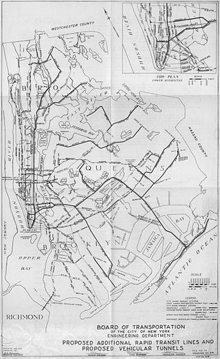
Since the opening of the original New York City Subway line in 1904, and throughout the subway's history, various official and planning agencies have proposed numerous extensions to the subway system. The first major expansion of the subway system was the Dual Contracts, a set of agreements between the City of New York and the IRT and the BRT. The system was expanded into the outer reaches of the Bronx, Brooklyn, and Queens, and it provided for the construction of important lines in Manhattan. This one expansion of the system provided for a majority of today's system.
The Second Avenue Subway is a New York City Subway line that runs under Second Avenue on the East Side of Manhattan. The first phase of this new line, with three new stations on Manhattan's Upper East Side, opened on January 1, 2017. The full Second Avenue Line, if it will be funded, will be built in three more phases to eventually connect Harlem–125th Street in Harlem to Hanover Square in Lower Manhattan. The proposed full line would be 8.5 miles (13.7 km) and 16 stations long, serve a projected 560,000 daily riders, and cost more than $17 billion.

The Delaware Aqueduct is an aqueduct in the New York City water supply system. It takes water from the Rondout, Cannonsville, Neversink, and Pepacton reservoirs on the west bank of the Hudson River through the Chelsea Pump Station, then into the West Branch, Kensico, and Hillview reservoirs on the east bank, ending at Hillview in Yonkers, New York.

The Steinway Tunnel is a pair of tubes carrying the IRT Flushing Line of the New York City Subway under the East River between 42nd Street in Manhattan and 51st Avenue in Long Island City, Queens, in New York City. It was originally designed and built as an interurban trolley tunnel, with stations near the current Hunters Point Avenue and Grand Central stations.
The IRT Broadway–Seventh Avenue Line is a New York City Subway line. It is one of several lines that serves the A Division, stretching from South Ferry in Lower Manhattan north to Van Cortlandt Park–242nd Street in Riverdale, Bronx. The Brooklyn Branch, known as the Wall and William Streets Branch during construction, from the main line at Chambers Street southeast through the Clark Street Tunnel to Borough Hall in Downtown Brooklyn, is also part of the Broadway–Seventh Avenue Line. The IRT Broadway–Seventh Avenue Line is the only line to have elevated stations in Manhattan, with two short stretches of elevated track at 125th Street and between Dyckman and 225th Streets.
The Croton Aqueduct or Old Croton Aqueduct was a large and complex water distribution system constructed for New York City between 1837 and 1842. The great aqueducts, which were among the first in the United States, carried water by gravity 41 miles (66 km) from the Croton River in Westchester County to reservoirs in Manhattan. It was built because local water resources had become polluted and inadequate for the growing population of the city. Although the aqueduct was largely superseded by the New Croton Aqueduct, which was built in 1890, the Old Croton Aqueduct remained in service until 1955.

A combination of aqueducts, reservoirs, and tunnels supplies fresh water to New York City. With three major water systems stretching up to 125 miles (201 km) away from the city, its water supply system is one of the most extensive municipal water systems in the world.

The Joralemon Street Tunnel, originally the Brooklyn–Battery Tunnel, is a pair of tubes carrying the IRT Lexington Avenue Line of the New York City Subway under the East River between Bowling Green Park in Manhattan and Brooklyn Heights in Brooklyn, New York City. The Joralemon Street Tunnel was an extension of the Interborough Rapid Transit Company (IRT)'s first subway line from the Bowling Green station in Manhattan to the IRT Eastern Parkway Line in Brooklyn.
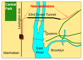
The 63rd Street Tunnel is a double-deck subway and railroad tunnel under the East River between the boroughs of Manhattan and Queens in New York City. Opened in 1989, it is the newest of the East River tunnels, as well as the newest rail river crossing in the New York metropolitan area. The upper level of the 63rd Street Tunnel carries the IND 63rd Street Line of the New York City Subway. The lower level carries Long Island Rail Road (LIRR) trains to Grand Central as part of the East Side Access project.

The Uptown Hudson Tubes are a pair of tunnels that carry PATH trains between Manhattan, New York City, to the east and Jersey City, New Jersey, to the west. The tubes originate at a junction of two PATH lines on the New Jersey shore and cross eastward under the Hudson River. On the Manhattan side, the tubes run mostly underneath Christopher Street and Sixth Avenue, making four intermediate stops before terminating at 33rd Street station. The tubes do not enter Uptown Manhattan; the name reflects their location north of the Downtown Hudson Tubes that connect Jersey City and the World Trade Center.
The Downtown Hudson Tubes are a pair of tunnels that carry PATH trains under the Hudson River in the United States, between New York City to the east and Jersey City, New Jersey, to the west. The tunnels run between the World Trade Center station on the New York side and the Exchange Place station on the New Jersey side.
The Hudson Terminal was a rapid transit station and office-tower complex in the Radio Row neighborhood of Lower Manhattan in New York City. Opened during 1908 and 1909, it was composed of a terminal station for the Hudson & Manhattan Railroad (H&M), as well as two 22-story office skyscrapers and three basement stories. The complex occupied much of a two-block site bounded by Greenwich, Cortlandt, Church, and Fulton Streets, which later became the World Trade Center site.
The New York City Department of Environmental Protection (DEP) is the department of the government of New York City that manages the city's water supply and works to reduce air, noise, and hazardous materials pollution.
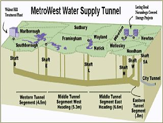
The MetroWest Water Supply Tunnel (MWWST) is an advanced underground aqueduct that supplies potable water to residents of much of Greater Boston. It is part of the Massachusetts Water Resources Authority (MWRA) water supply system, having entered operation in November 2003.

The New Croton Aqueduct is an aqueduct in the New York City water supply system in Westchester County, New York carrying the water of the Croton Watershed. Built roughly parallel to the Old Croton Aqueduct which it originally augmented, the new aqueduct opened in 1890. The old aqueduct remained in service until 1955, when supply from the Delaware and Catskill Aqueducts was sufficient to allow taking it off line.

Tibbetts Brook, originally Tippett's Brook or Tibbitt's Brook, is a stream in the southern portion of mainland New York, flowing north to south from the city of Yonkers in Westchester County into the borough of the Bronx within New York City. Originally emptying into Spuyten Duyvil Creek as part of the Harlem River system, the stream is now partially subterranean, ending above ground at the south end of Van Cortlandt Lake within Van Cortlandt Park. There it proceeds into city sewers, draining into either the northern end of the Harlem River or the Wards Island Water Pollution Control Plant. The brook provides significant watershed to both Van Cortlandt Park at its south end and Tibbetts Brook Park at its north end. There have been modern proposals to daylight the southern portion of the brook back onto the surface.

The Second Avenue Subway, a New York City Subway line that runs under Second Avenue on the East Side of Manhattan, has been proposed since 1920; the first phase of the line did not open until 2017. Up until the 1960s, many distinct plans for the Second Avenue subway line were never carried out, though small segments were built in the 1970s. The complex reasons for these delays are why the line is sometimes called "the line that time forgot".

The Croton Water Filtration Plant, is a drinking water treatment facility in New York City which began operation in 2015. The plant construction cost was over $3 billion, The facility was built 160 feet (49 m) under Van Cortlandt Park's Mosholu Golf Course in the Bronx.
References
- 1 2 Dwyer, Jim (April 5, 2016). "De Blasio Postpones Work on Crucial Water Tunnel". The New York Times.
- 1 2 3 Flegenheimer, Matt (October 16, 2013). "After Decades, a Water Tunnel Can Now Serve All of Manhattan". The New York Times.
- 1 2 3 4 Chan, Sewell (August 10, 2006). "Tunnelers Hit Something Big: A Milestone". The New York Times.
It is the biggest public works project in New York City's history: a $6 billion water tunnel that has claimed 24 lives, endured under six mayors and survived three city fiscal crises, along with the falling and rising fortunes of the metropolis above it. ...
- 1 2 Kensinger, Nathan (April 22, 2021). "NYC's Giant Water Tunnel Begins Work On Final Shafts, Following 50 Years Of Construction". The Gothamist. Retrieved August 11, 2021.
- 1 2 "A Practical Perspective in Building Resilience into Urban Water Management by Commissioner Rohit T. Aggarwala". NYCDEP. September 20, 2022.
- 1 2 Grann, David (September 1, 2003). "City of Water". The New Yorker. Condé Nast. pp. 88–103.
- 1 2 3 4 5 City Water Tunnel No. 3 Fact Sheet (PDF) (Report). NYC Department of Environmental Protection (NYCDEP). 2006. Archived from the original (PDF) on January 1, 2013. Retrieved October 21, 2013.
- ↑ water-technology.net "New York City Tunnel No. 3, United States of America". Net Resources International. Retrieved December 15, 2011.
- ↑ New York City 2008 Drinking Water Supply and Quality Report (PDF) (Report). NYCDEP. 2008. p. 6.
- ↑ "Commissioner's Corner". NYCDEP. September 13, 2022.
- ↑ Cohen, Noam S. (September 2, 1991). "Body of Bronx Boy Retrieved From a 500-Foot Shaft". The New York Times.
- ↑ Engquist, Erik (April 6, 2016). "De Blasio does damage control in wake of New York Times' water-tunnel story". Crain's New York Business. Retrieved August 31, 2017.
- ↑ "What's the real story behind the final phase of Water Tunnel No. 3?". New York Business Journal. Advance Publications Inc. April 6, 2016.
- ↑ Giambusso, David (January 23, 2017). "De Blasio to allocate $300M for water tunnel". Politico.
- ↑ Kensinger, Nathan (April 22, 2021). "NYC's Giant Water Tunnel Begins Work On Final Shafts, Following 50 Years Of Construction". Gothamist.