The Docklands Light Railway (DLR) is an automated light metro system serving the redeveloped Docklands area of London, England. First opened on 31 August 1987, the DLR has been extended multiple times, giving a total route length of 38 km (24 mi). Lines now reach north to Stratford, south to Lewisham, west to Tower Gateway and Bank in the City of London financial district, and east to Beckton, London City Airport and Woolwich Arsenal. Further extensions are under consideration.

Stratford is a town in east London, England, within the ceremonial county of Greater London and the historic county of Essex. Part of the Lower Lea Valley, Stratford is situated 6 miles (10 km) east-northeast of Charing Cross, and includes the localities of Maryland, East Village, Mill Meads and Stratford City.
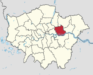
The London Borough of Newham is a London borough created in 1965 by the London Government Act 1963. It covers an area previously administered by the Essex county boroughs of West Ham and East Ham, authorities that were both abolished by the same act. The name Newham reflects its creation and combines the compass points of the old borough names. Situated on the borders of inner and outer East London, Newham has a population of 353,134, which is the third highest of the London boroughs and also makes it the 20th most populous district in England. The local authority is Newham London Borough Council.

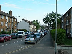
Silvertown is a district in the London Borough of Newham, in east London, England. It lies on the north bank of the Thames and was historically part of the parish and borough of West Ham, hundred of Becontree, and the historic county of Essex. Since 1965, Silvertown has been part of the London Borough of Newham, a local government district of Greater London. It forms part of the London E16 postcode district along with Canning Town and Custom House.

Canning Town is a London Underground, Docklands Light Railway (DLR) and London Buses station in Canning Town in London, England. It is designed as an intermodal metro and bus station, fully opening in 1999 as part of the Jubilee Line Extension - replacing the original station site north of the A13. On 11 November 2015, the Mayor of London announced that it would be rezoned to be on the boundary of Travelcard Zone 2 and Travelcard Zone 3.

Custom House is a railway station on the Docklands Light Railway (DLR) – on which it is branded Custom House for ExCeL – and on the Elizabeth line, by the Royal Docks, in Custom House in the London Borough of Newham, London, England. It is situated in Travelcard Zone 3. It takes its name from the old Custom House, which formerly stood nearby, and ExCeL London which it serves.

Royal Albert DLR station is a station on the Docklands Light Railway (DLR) in Beckton in east London. The station serves the western end of the north quay of the Royal Albert Dock, from which it takes its name. A view of the London City Airport is available.

Beckton is a suburban district in East London, England, within the London Borough of Newham and is located 8 miles (12.9 km) east of Charing Cross. Historically part of Essex, Beckton was unpopulated marshland adjacent to the River Thames until the development of major industrial infrastructure in the 19th century to support the growing metropolis of London. Housing was created in Beckton for workers of the gas and sewage works. Between 1981 and 1995 it was within the London Docklands Development Corporation area, which caused the population to increase as new homes were built and the Docklands Light Railway was constructed.

The Three Mills are former working mills and an island of the same name on the River Lea. It is one of London’s oldest extant industrial centres. The mills lie in the London Borough of Newham; and, despite lying on the Newham side of the Lea, access is principally from the western, London Borough of Tower Hamlets, side of the river.

Pudding Mill Lane is a Docklands Light Railway (DLR) station in Stratford in London, England. It opened in 1996 on the road of the same name, once a light industrial area in Stratford, now being redeveloped into housing development called Pudding Mill Lane. It is next to the Olympic Park; however, it was closed for the duration of the 2012 Olympic Games and reopened on 12 September 2012. The original island platform station was permanently closed on 18 April 2014 in order to allow for the construction of a ramp from the new Crossrail portal nearby. A new, larger station built a short distance to the south opened on 28 April 2014.

The Lower Lea Valley is the southern end of the Lea Valley which surrounds the River Lea. It is part of the Thames Gateway redevelopment area and was the location of the 2012 Summer Olympics.

East London is a part of London, capital of the United Kingdom, east of the ancient City of London and north of the River Thames, which comprises the London boroughs of Barking and Dagenham, Hackney, Havering, Newham, Redbridge, Tower Hamlets and Waltham Forest. The East End of London is a subset of East London, consisting of areas close to the ancient City of London. The Eastern (E) Postal District is a different subset of East London; and there is also an "East" sub-region used in the London Plan for planning policy reporting purposes. The 2011 iteration includes seven boroughs north of the Thames, with the addition of three boroughs south of the river.

London City Airport is a light metro station on the Docklands Light Railway (DLR) Stratford-Woolwich and Bank-Woolwich Lines; serving London City Airport in East London. It opened on 2 December 2005. It was first located on what was initially King George V branch, and was, until the extension to Woolwich Arsenal was completed, the reason for this branch. It continues to be an important station on the DLR. Trains run westbound to Bank in the City of London, northbound to Stratford International and eastbound to Woolwich Arsenal. The station is in the London Borough of Newham and is located in Travelcard Zone 3.

Abbey Road DLR station is a Docklands Light Railway station in West Ham in the London Borough of Newham, in east London, England. It is located on the Stratford International extension of the Docklands Light Railway.

Star Lane is a Docklands Light Railway (DLR) station in Canning Town, east London. Located on the Stratford International extension of the Docklands Light Railway between Stratford and Canning Town, it opened on 31 August 2011.

North Woolwich railway station in North Woolwich in east London was the eastern terminus of the North London Line. The station closed in 2006, to allow for the North London line between Stratford and Canning Town to be converted to Docklands Light Railway (DLR) operation. The local area is now served by the nearby King George V DLR station. The historic station building was Grade II-listed in 1998.
Thames Wharf is a planned Docklands Light Railway station in the Royal Docks, East London. The station name was previously proposed for another station in the area.

Three Mills Residential Moorings is a community of twenty residential narrowboats moored on the Three Mills Wall River Weir near Three Mills in Mill Meads.
Stratford Market was a wholesale fruit and vegetable market, located in Stratford in the London Borough of Newham. Opened in 1879 by the Great Eastern Railway as a competitor to Spitalfields Market in the City of London, the market closed in 1991 and consolidated at the New Spitalfields Market in Leyton. The site is now home to Stratford Market Depot.