Goddington is an area in south-east London, located in the London Borough of Bromley. It is situated south of Ramsden, south-east of Orpington town centre, and north of Chelsfield. It lies directly adjacent to the London Green Belt. Until 1965 it lay in the historic county of Kent.

Stratford is a town in East London, England, within the London Borough of Newham. Part of the Lower Lea Valley, Stratford is situated 6 miles (9.7 km) east-northeast of Charing Cross, and includes the localities of Maryland and East Village.
West Ham is an area in East London, located 6.1 mi (9.8 km) east of Charing Cross in the west of the modern London Borough of Newham.
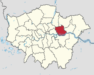
The London Borough of Newham is a London borough created in 1965 by the London Government Act 1963. It covers an area previously administered by the Essex county boroughs of West Ham and East Ham, authorities that were both abolished by the same act. The name Newham reflects its creation and combines the compass points of the old borough names. Situated in the Inner London part of East London, Newham has a population of 387,576, which is the fourth highest of the London boroughs and also makes it the 26th most populous district in England. The local authority is Newham London Borough Council.
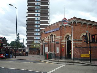
Plaistow is a suburban area of East London, England, within the London Borough of Newham. It adjoins Upton Park to the north, East Ham to the east, Beckton to the south, Canning Town to the south-west and West Ham to the west.

East Ham is a district of the London Borough of Newham, England, 8 miles (12.8 km) east of Charing Cross. Within the boundaries of the historic county of Essex, East Ham is identified in the London Plan as a Major Centre. The population is 76,186.

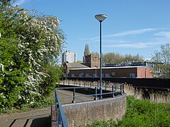
Canning Town is a district in the London Borough of Newham, East London. The district is located to the north of the Royal Victoria Dock, and has been described as the "Child of the Victoria Docks" as the timing and nature of its urbanisation was largely due to the creation of the dock. The area was part of the ancient parish of West Ham, in the hundred of Becontree, and part of the historic county of Essex. It forms part of the London E16 postcode district.
Barkingside is an area in Ilford, in the London Borough of Redbridge. It includes the major road junction of Fullwell Cross which also gives its name to the locality near that roundabout. The area is situated 10.6 miles (17km) north east of Charing Cross. Prior to 1965, it formed part of the borough of Ilford in the historic county of Essex.

West Heath is an area of South East London within the London Borough of Bexley. It lies south of Abbey Wood and north of Welling.
Westbourne Green is an area of Westbourne, London, the centre of the former hamlet of Westbourne, at the north-western corner of the City of Westminster. It is named for its location west of a bourne.
Bandonhill is a small locality in the London Borough of Sutton, located between Wallington and Beddington.
Chase Cross is a district of the London Borough of Havering in London, England. Chase Cross lies 0.8 miles (1.3 km) east of Collier Row, 15 miles (24 km) northeast of Charing Cross and just under 2 miles (3.2 km) north of Romford. The name is thought to come from its position as a crossroads in the chase or Hainault Forest. The forest was cleared for agriculture in the 1850s, before being developed for housing in the 1930s.
Blendon is an area of South East London within the London Borough of Bexley, located between Bexleyheath and Sidcup.

Elmers End is an area of south-east London, England, within the London Borough of Bromley, Greater London and formerly part of the historic county of Kent. It is located south of Beckenham, west of Eden Park, north of Monks Orchard and east of Anerley.

Plashet is a locality of East Ham in the London Borough of Newham in East London located between West Ham and Manor Park. It contains Plashet Jewish Cemetery, Plashet Park, and several places of worship.

Brentford End is a small area located in the borough of Hounslow, London to the west of Brentford and east of Isleworth. It is a little-used name for that section of Brentford situated to the west of the river Brent.

Broom Hill, sometimes spelt Broomhill, is a suburb of Orpington in southeast London, England, located in the London Borough of Bromley in Greater London. Prior to 1965 it was within the historic county of Kent. It lies south of Poverest, west of Orpington High Street, north-east of Crofton, and south-east of Petts Wood.

Luxted is a hamlet in the London Borough of Bromley, located to the south of Downe, at grid reference TQ434602. The area is rural, noted for its abundance of woods and grasslands. It is a part of the largest ward in Greater London, the Darwin ward, which also includes Downe, Cudham, Leaves Green, Single Street, Berry's Green, and Westerham Hill.

Poverest is an area in south-east London, England, within the London Borough of Bromley in Greater London. Prior to 1965 it was within the historic county of Kent. It lies south of St Paul's Cray, west of St Mary Cray, north of Orpington and Broom Hill, and east of Petts Wood.
Derry Downs is an area of south-east London, England, within the London Borough of Bromley and, prior to 1965, in the historic county of Kent. It is located south of St Mary Cray, west of Kevington, north of Ramsden, and east of Orpington.