Hunterdon County is a county located in the western section of the U.S. state of New Jersey. At the 2020 census, the county was the state's 18th-most populous county, with a population of 128,947, its highest decennial count ever and an increase of 598 (+0.5%) from the 2010 census count of 128,349, which in turn reflected an increase of 6,360 (5.2%) from the 121,989 counted in the 2000 census. Its county seat is Flemington. The county is part of the Central Jersey region of the state.

Route 31 is a state highway in New Jersey, United States. It runs 48.93 mi (78.75 km) from U.S. Route 1 Business /US 206 in Trenton, Mercer County, north to an intersection with US 46 in Buttzville in White Township, Warren County. Along the way, Route 31 heads through the communities of Flemington, Clinton, and Washington. Most of the highway is state-maintained; however, the section within the city limits of Trenton is maintained by the city. Much of Route 31 is a two-lane highway that passes through farmland, woodland, and mountainous areas. Two portions of the route—from Trenton to Pennington and from Ringoes to Clinton—consist of more development.

Route 57 is a state highway located in Warren County in the U.S. state of New Jersey. It runs 21.10 mi (33.96 km) from an interchange with U.S. Route 22 (US 22) in Lopatcong Township to an intersection with Route 182 and County Route 517 (CR 517) in Hackettstown. The route passes through mostly rural areas of farmland and mountains in Warren County. It also passes through Washington, where Route 57 crosses Route 31. The route is designated a scenic byway, the Warren Heritage Scenic Byway, by the state of New Jersey due to the physical environments it passes through as well as from historical sites along the way such as the Morris Canal.
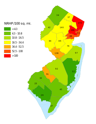
This is a list of properties and districts listed on the National Register of Historic Places in New Jersey. There are more than 1,700 listed sites in New Jersey. Of these, 58 are further designated as National Historic Landmarks. All 21 counties in New Jersey have listings on the National Register.
This National Park Service list is complete through NPS recent listings posted May 10, 2024.
Miller Farm or Miller Farmstead may refer to:

Finesville is an unincorporated community and census-designated place (CDP) located within Pohatcong Township in Warren County, in the U.S. state of New Jersey. The CDP was defined as part of the 2010 United States Census. As of the 2010 Census, the CDP's population was 175.

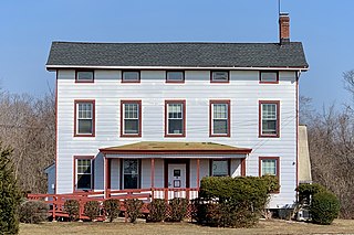
Readingsburg, also known as Stone Mill, is an unincorporated community located along the South Branch Raritan River within Clinton Township in Hunterdon County, New Jersey.
Amsterdam is an unincorporated community located within Holland Township in Hunterdon County, in the U.S. state of New Jersey. Located on the southern flank of the Musconetcong Mountain, the area was settled in the first half of the 18th century. It was later named after Amsterdam, Netherlands. The Amsterdam Historic District, encompassing the community, was listed on the state and national registers of historic places in 1995.
Penwell is an unincorporated community located within Lebanon Township in Hunterdon County, in the U.S. state of New Jersey.
The New Hampton Historic District is a 76-acre (31 ha) historic district in the village of New Hampton in Lebanon Township in Hunterdon County, New Jersey, United States. The district was added to the National Register of Historic Places on April 6, 1998, for its significance in architecture, commerce, education, transportation, and community development from c. 1780 to 1929. It includes 42 contributing buildings, six contributing sites, and four contributing structures located along Musconetcong River Road.

The Asbury Historic District is a 288-acre (117 ha) historic district encompassing the community of Asbury in Franklin Township of Warren County, New Jersey. It is bounded by County Route 632, County Route 643, Maple Avenue, Kitchen Road, and School Street and extends along the Musconetcong River into Bethlehem Township of Hunterdon County. It was listed on the National Register of Historic Places on March 19, 1993 for its significance in architecture, industry, religion, community development, politics/government, and commerce. The district includes 141 contributing buildings, a contributing structure, two contributing sites, and four contributing objects.

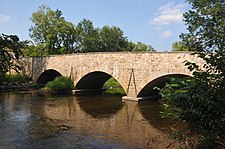
The New Hampton Pony Pratt Truss Bridge is a historic pony Pratt truss bridge on Shoddy Mill Road in New Hampton of Lebanon Township, Hunterdon County, New Jersey. It crosses the Musconetcong River between Lebanon Township, Hunterdon County and Washington Township, Warren County. It was designed by Francis C. Lowthorp and built in 1868 by William Cowin of Lambertville, New Jersey. The bridge was added to the National Register of Historic Places on July 26, 1977 for its significance in engineering, industry and transportation. It is one of the few early examples of iron Pratt truss bridges remaining in the United States. It was later documented by the Historic American Engineering Record in 1991. It was added as a contributing property to the New Hampton Historic District on April 6, 1998.

The Imlaydale Historic District is a 32-acre (13 ha) historic district primarily in Washington Township of Warren County, New Jersey. It was added to the National Register of Historic Places on March 27, 1991 for its significance in architecture, community development, industry, politics/government, and transportation. The listing includes 12 contributing buildings, four contributing structures, and two contributing sites.

The Covered Bridge Historic District, in Delaware Township, Hunterdon County, New Jersey, is a 97-acre (39 ha) historic district along County Route 604, Pine Hill Road, and Lower Creek Road. It was listed on the National Register of Historic Places on March 5, 1999, for its significance in architecture, settlement, and transportation. The listing included seven contributing buildings, two contributing structures, and three contributing sites.

Pursley's Ferry Historic District is a 61-acre (25 ha) historic district located along Old River Road near Church Road by the Delaware River in Holland Township, Hunterdon County, New Jersey. It was added to the National Register of Historic Places on October 8, 1980 for its significance in architecture, commerce, and transportation. The district includes 4 contributing buildings.
The Raritan–Readington South Branch Historic District is a 556-acre (225 ha) historic district along River Road from New Jersey Route 31 to U.S. Route 202 near Flemington in Hunterdon County, New Jersey. It is primarily on the western side of the South Branch Raritan River in Raritan Township. It extends onto the eastern side of the river in Readington Township. County Route 523 and County Route 612 pass through the district to the north. The district encompasses the small settlements of Holcomb Mills, Flemington Junction, and Rockefellows Mills. It was added to the National Register of Historic Places on January 26, 1990, for its significance in architecture, politics, transportation, and exploration/settlement. The district includes 36 contributing buildings, four contributing structures, and three contributing sites. It also includes the John Reading Farmstead, previously listed on the NRHP individually.

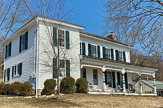
The Case Farmstead, also known as the Daniel Case / Sarah Clark Case Farmstead, is a historic 88-acre (36 ha) farm located along County Route 614 near Pattenburg in Union Township, Hunterdon County, New Jersey. It was added to the National Register of Historic Places on August 14, 1979, for its significance in architecture and medicine. The farmstead includes three contributing buildings.

The Stone Sign Post Road Bridge over Plum Brook is a historic Warren truss bridge located in Delaware Township in Hunterdon County, New Jersey, United States. Built in 1903 by John W. Scott of Flemington, it was added to the National Register of Historic Places on October 4, 2016, for its significance in engineering. It was listed as part of the Historic Bridges of Delaware Township, Hunterdon County, New Jersey Multiple Property Submission (MPS).
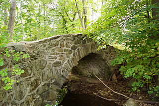
The Palatine Road Brige is a historic stone arch bridge that carries Palatine Road over a minor tributary of the Lamington River in Tewksbury Township of Hunterdon County, New Jersey, United States. Built in 1900 by George Schuyler, it was added to the National Register of Historic Places on December 12, 2002, for its significance in engineering and transportation. It was listed as part of the Historic Bridges of Tewksbury Township, Hunterdon County, New Jersey Multiple Property Submission (MPS).
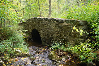
The Frog Hollow Road Bridge is a historic stone arch bridge that carries Frog Hollow Road over a minor tributary of the South Branch Raritan River in Tewksbury Township of Hunterdon County, New Jersey, United States. Built between 1860 and 1873, it was added to the National Register of Historic Places on December 12, 2002, for its significance in engineering and transportation. It was listed as part of the Historic Bridges of Tewksbury Township, Hunterdon County, New Jersey Multiple Property Submission (MPS).