Buccleuch Mansion is located in Buccleuch Park in New Brunswick in Middlesex County, New Jersey, along the Raritan River.
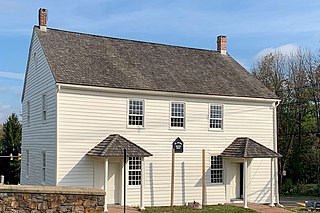
The Mount Bethel Baptist Meetinghouse is a historic church located at the intersection of County Route 651 and Mountainview Road in the village of Mount Bethel in Warren Township, Somerset County, New Jersey, United States. Built in 1786, it was added to the National Register of Historic Places on June 3, 1976, for its significance in architecture and religion.

The Fairview Schoolhouse is located east of Columbia in the Fairview Cemetery along Dean Road in Knowlton Township in Warren County, New Jersey, United States. It was built in 1835 and documented by the Historic American Buildings Survey (HABS) in 1937. The schoolhouse was added to the National Register of Historic Places on August 12, 1977, for its significance in architecture and education. It is now used by the Fairview Cemetery Association.

The Allamuchy Freight House is located in Allamuchy Township of Warren County, New Jersey. This freight house was built in 1906 and was added to the National Register of Historic Places on September 23, 2002, for its significance in transportation. It was built by the Lehigh and Hudson River Railway and is the only freight house on the line still extant.

Finesville is an unincorporated community and census-designated place (CDP) located within Pohatcong Township in Warren County, in the U.S. state of New Jersey. The CDP was defined as part of the 2010 United States Census. As of the 2010 Census, the CDP's population was 175.

Headquarters is an unincorporated community located within the Amwell Valley of Delaware Township in Hunterdon County, New Jersey. The settlement is centered around the intersection of Zentek Road and County Route 604. It is about 3 miles (4.8 km) from Ringoes to the east and 1 mile (1.6 km) from Sergeantsville to the west. The Headquarters Historic District was listed on the state and national registers of historic places in 2011 and had its boundary increased in 2016.

Millbrook, also known as Millbrook Village, is an unincorporated community located along Old Mine Road within Hardwick Township, formerly Pahaquarry Township, in Warren County, in the U.S. state of New Jersey. It is named after the Mill Brook, now known as Van Campens Mill Brook, a tributary of the Delaware River. The area is now part of the Delaware Water Gap National Recreation Area.

The Kingston Mill Historic District is a 49-acre (20 ha) historic district in Kingston, New Jersey. It is roughly bounded by the Millstone, River, and Princeton-Kingston Roads in the townships of Princeton in Mercer County, South Brunswick in Middlesex County, and Franklin in Somerset County. It was added to the National Register of Historic Places on April 10, 1986 for its significance in engineering, exploration/settlement, industry, and transportation. The district includes 16 contributing buildings and 2 contributing structures.

The Belvidere Historic District is a 132-acre (53 ha) historic district encompassing the town of Belvidere, the county seat of Warren County, New Jersey, United States. It was added to the National Register of Historic Places on October 3, 1980 for its significance in architecture, commerce, community planning, industry, politics and government during the 19th century. The district is bounded by Market and Race streets; Greenwich and Mansfield avenues; and the Pequest River. It contains 228 contributing buildings, including the Warren County Courthouse.

The Asbury Historic District is a 288-acre (117 ha) historic district encompassing the community of Asbury in Franklin Township of Warren County, New Jersey. It is bounded by County Route 632, County Route 643, Maple Avenue, Kitchen Road, and School Street and extends along the Musconetcong River into Bethlehem Township of Hunterdon County. It was listed on the National Register of Historic Places on March 19, 1993 for its significance in architecture, industry, religion, community development, politics/government, and commerce. The district includes 141 contributing buildings, a contributing structure, two contributing sites, and four contributing objects.

The New Hampton Pony Pratt Truss Bridge is a historic pony Pratt truss bridge on Shoddy Mill Road in New Hampton of Lebanon Township, Hunterdon County, New Jersey. It crosses the Musconetcong River between Lebanon Township, Hunterdon County and Washington Township, Warren County. It was designed by Francis C. Lowthorp and built in 1868 by William Cowin of Lambertville, New Jersey. The bridge was added to the National Register of Historic Places on July 26, 1977 for its significance in engineering, industry and transportation. It is one of the few early examples of iron Pratt truss bridges remaining in the United States. It was later documented by the Historic American Engineering Record in 1991. It was added as a contributing property to the New Hampton Historic District on April 6, 1998.
The Miller Farmstead is a historic district encompassing the main farm complex on Route 57, at Watters Road, in Mansfield Township, Warren County, New Jersey and extending into Lebanon Township, Hunterdon County. The farmstead is near the community of Penwell and overlooks the Musconetcong River, arranged linearly along the upper edge of the river's flood plain. It was added to the National Register of Historic Places on September 11, 1989, for its significance in agriculture, architecture, and transportation from 1830 to 1924. The listing is a 108 acres (44 ha) area that includes eight contributing buildings, seven contributing structures, and a contributing site.

The Old Mine Road Historic District is a 687-acre (278 ha) historic district located along Old Mine Road in Sussex County and Warren County, New Jersey. It is part of the Delaware Water Gap National Recreation Area. The district was added to the National Register of Historic Places on December 3, 1980, for its significance in agriculture, archaeology, architecture, commerce, exploration/settlement, and transportation. It includes 24 contributing buildings and five contributing sites.

The Imlaydale Historic District is a 32-acre (13 ha) historic district primarily in Washington Township of Warren County, New Jersey. It was added to the National Register of Historic Places on March 27, 1991 for its significance in architecture, community development, industry, politics/government, and transportation. The listing includes 12 contributing buildings, four contributing structures, and two contributing sites.

The Beattystown Historic District is a 35-acre (14 ha) historic district in the village of Beattystown in Mansfield Township of Warren County, New Jersey, United States. The district was added to the National Register of Historic Places on September 28, 1990 for its significance in architecture, commerce, industry, and settlement pattern from 1762 to 1929. It includes 32 contributing buildings.

Bowerstown is an unincorporated community in Washington Township, Warren County, New Jersey near the Morris Canal and the Pohatcong Creek. It was founded in 1829 by Jesse Vanetta and Michael B. Bowers with the building of an iron foundry. The Bowerstown Historic District, encompassing the village, was listed on the state and national registers of historic places in 1996.

Pleasant Valley is an unincorporated community located in Washington Township, Warren County, New Jersey, west of Washington, along the Pohatcong Creek. The hamlet was built around a mill on the creek during the mid-18th century. The Pleasant Valley Historic District, encompassing the village, is listed on the state and national registers of historic places.

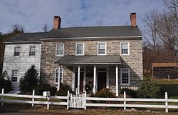
The Kirch–Ford House, also known as the Kirch–Ford–Terrill House, is a historic farmhouse located at the corner Reinman Road and Mount Bethel Road in Warren Township in Somerset County, New Jersey. The house was added to the National Register of Historic Places on October 20, 1988, for its significance in architecture and exploration/settlement. It is now a historic house museum owned by the township.

Riegelsville is an unincorporated community located in Pohatcong Township in Warren County, New Jersey. It is connected to Riegelsville, Pennsylvania across the Delaware River by the Riegelsville Bridge at the confluence of the Musconetcong River with the Delaware River.

Millville is an unincorporated community located along River Road and Shimers Brook in Montague Township of Sussex County, New Jersey. The Montague Grange and other parts of the community are in the Delaware Water Gap National Recreation Area.