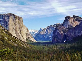
Yosemite Valley is a glacial valley in Yosemite National Park in the western Sierra Nevada mountains of Central California. The valley is about 7.5 mi (12.1 km) long and 3,000–3,500 ft (910–1,070 m) deep, surrounded by high granite summits such as Half Dome and El Capitan, and densely forested with pines. The valley is drained by the Merced River, and a multitude of streams and waterfalls flow into it, including Tenaya, Illilouette, Yosemite and Bridalveil Creeks. Yosemite Falls is the highest waterfall in North America and is a big attraction especially in the spring, when the water flow is at its peak. The valley is renowned for its natural environment and is regarded as the centerpiece of Yosemite National Park.
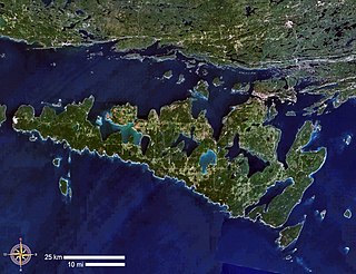
Manitoulin Island is an island in Lake Huron, located within the borders of the Canadian province of Ontario, in the bioregion known as Laurentia. With an area of 2,766 km2 (1,068 sq mi), it is the largest lake island in the world, large enough that it has over 100 inland lakes itself. In addition to the historic Anishinaabe and European settlement of the island, archeological discoveries at Sheguiandah have demonstrated Paleo-Indian and Archaic cultures dating from 10,000 BC to 2,000 BC.
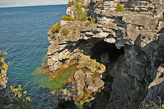
Bruce Peninsula National Park is a national park on the Bruce Peninsula in Ontario, Canada. Located on a part of the Niagara Escarpment, the park comprises 156 square kilometres and is one of the largest protected areas in southern Ontario, forming the core of UNESCO's Niagara Escarpment World Biosphere Reserve. It was established in 1987 to protect the rock formations and shoreline of the Niagara Escarpment. The park offers opportunities for many outdoor activities, including hiking, camping, and bird watching. The park has trails ranging in difficulty from easy to expert, and connects to the Bruce Trail. Bruce Peninsula National Park is known for its crystal clear blue waters, cobblestone beaches, rocky cliffs and karst formations.
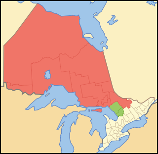
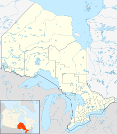
Northern Ontario is a primary geographic and quasi-administrative region of the Canadian province of Ontario, the other primary region being Southern Ontario. Most of the core geographic region is located on part of the Superior Geological Province of the Canadian Shield, a vast rocky plateau located mainly north of Lake Huron, the French River, Lake Nipissing, and the Mattawa River. The statistical region extends south of the Mattawa River to include all of the District of Nipissing. The southern section of this district lies on part of the Grenville Geological Province of the Shield which occupies the transitional area between Northern and Southern Ontario. The extended federal and provincial quasi-administrative regions of Northern Ontario have their own boundaries even further south in the transitional area that vary according to their respective government policies and requirements. Ontario government departments and agencies such as the Growth Plan for Northern Ontario and the Northern Ontario Heritage Fund Corporation define Northern Ontario as all areas north of, and including, the districts of Parry Sound and Nipissing for political purposes, whilst the federal government, but not the provincial, also includes the district of Muskoka.

Algonquin Provincial Park is a provincial park located between Georgian Bay and the Ottawa River in Ontario, Canada, mostly within the Unorganized South Part of Nipissing District. Established in 1893, it is the oldest provincial park in Canada. Additions since its creation have increased the park to its current size of about 7,653 km2 (2,955 sq mi). The park is contiguous with several smaller, administratively separate provincial parks that protect important rivers in the area, resulting in a larger total protected area.

Georgian Bay is a large bay of Lake Huron, in the Laurentia bioregion. It is located entirely within the borders of Ontario, Canada. The main body of the bay lies east of the Bruce Peninsula and Manitoulin Island. To its northwest is the North Channel.

An alvar is a biological environment based on a limestone plain with thin or no soil and, as a result, sparse grassland vegetation. Often flooded in the spring, and affected by drought in midsummer, alvars support a distinctive group of prairie-like plants. Most alvars occur either in northern Europe or around the Great Lakes in North America. This stressed habitat supports a community of rare plants and animals, including species more commonly found on prairie grasslands. Lichen and mosses are common species. Trees and bushes are absent or severely stunted.

Mount Hope Cemetery in Rochester, New York, founded in 1838, is the first municipal cemetery in the United States. Situated on 196 acres (79 ha) of land adjacent to the University of Rochester on Mount Hope Avenue, the cemetery is the permanent resting place of over 350,000 people. The annual growth rate of this cemetery is 500-600 burials per year.

The Bruce Peninsula is a peninsula in Ontario, Canada, that divides Georgian Bay of Lake Huron from the lake's main basin. The peninsula extends roughly northwestwards from the rest of Southwestern Ontario, pointing towards Manitoulin Island, with which it forms the widest strait joining Georgian Bay to the rest of Lake Huron. The Bruce Peninsula contains part of the geological formation known as the Niagara Escarpment.

Glacier Bay National Park and Preserve is an American national park located in Southeast Alaska west of Juneau. President Calvin Coolidge proclaimed the area around Glacier Bay a national monument under the Antiquities Act on February 26, 1925. Subsequent to an expansion of the monument by President Jimmy Carter in 1978, the Alaska National Interest Lands Conservation Act (ANILCA) enlarged the national monument by 523,000 acres on December 2, 1980, and created Glacier Bay National Park and Preserve. The national preserve encompasses 58,406 acres of public land to the immediate northwest of the park, protecting a portion of the Alsek River with its fish and wildlife habitats, while allowing sport hunting.

Rondeau Provincial Park is the second oldest provincial park in Ontario, Canada, having been established with an order in council on 8 September 1894. The park is located in Southwestern Ontario, on an 8 km long crescentic sand spit extending into Lake Erie. Rondeau is home to the largest area of Carolinian forest in Canada, a long sand beach, a large marsh, approximately half of Rondeau Bay, campgrounds and a cottage community. The name of the park comes from the French words "ronde eau" or "round water" which describes the shape of the harbour sheltered by the peninsula.
St. Joseph Island is in the northwestern part of Lake Huron. It is part of the Canadian province of Ontario. At 365 km2 (141 sq mi) in area, it is the sixth largest lake island in the world; the second largest island on Lake Huron, following Manitoulin Island; and the third largest of all the islands on the Great Lakes, trailing Manitoulin and Lake Superior's Isle Royale.

Awenda Provincial Park is a provincial park in Tiny Township, Simcoe County in Central Ontario, Canada, located on a peninsula jutting into Georgian Bay north of Penetanguishene. The park occupies an area of 2,915 hectares and was established in 1975. It is classified as a Natural Environment Park and therefore all land is protected.

The Wiikwemkoong First Nation is a First Nation on Manitoulin Island in Northern Ontario. The Wiikwemkoong Unceded Territory is the First Nation reserve in the north-eastern section of Manitoulin Island in Manitoulin District, Ontario, Canada. Wiikwemkoong is an unceded Indigenous reserve in Canada, which means that it has not "relinquished title to its land to the government by treaty or otherwise."

The North Shore of Lake Superior runs from Duluth, Minnesota, United States, at the southwestern end of the lake, to Thunder Bay and Nipigon, Ontario, Canada, in the north to Sault Ste. Marie, Ontario, in the east. The shore is characterized by alternating rocky cliffs and cobblestone beaches, with forested hills and ridges through which scenic rivers and waterfalls descend as they flow to Lake Superior.

Grand Portage State Park is a state park at the northeastern tip of the U.S. state of Minnesota, on the Canada–United States border. It contains a 120-foot (37 m) waterfall, the tallest in the state, on the Pigeon River. The High Falls and other waterfalls and rapids upstream necessitated a historically important portage on a fur trade route between the Great Lakes and inland Canada. This 8.5-mile (13.7 km) path as well as the sites of historic forts at either end are preserved in nearby Grand Portage National Monument.
Birds Hill Provincial Park is a provincial park in Manitoba, Canada located in the Boreal Plains ecozone. The park protects areas representative of Aspen/Oak parkland, as well as provides opportunities for recreation. It is located 24 kilometers north of Winnipeg on Highway 59, and covers approximately 8,300 acres or 35.1 km2.

Killarney Provincial Park is a provincial park in central Ontario, Canada.
Rouge National Urban Park is a national urban park in Ontario, Canada. The park is centred around the Rouge River and its tributaries in the Greater Toronto Area. The southern portion of the park is situated around the mouth of river, in Scarborough, and extends northwards into Markham, Pickering, Uxbridge, and Whitchurch-Stouffville.

Neys Provincial Park is a Natural Environment Class provincial park on the north shore of Lake Superior, just west of Marathon, Ontario, Canada. This 5,383-hectare (13,300-acre) park includes the historic Coldwell Peninsula and the surrounding island system consisting of Pic Island, Detention Island, and the Sullivan Islands.