Mission Hill, South Dakota

Last updated

Mission Hill, South Dakota
Yankton County South Dakota Incorporated and Unincorporated areas Mission Hill Highlighted.svg
Location in Yankton County and the state of South Dakota
Coordinates: 42°55′15″N97°16′45″W / 42.92083°N 97.27917°W / 42.92083; -97.27917
Country United States
State South Dakota
County Yankton
Incorporated1913 [1]
Area
[2]
  Total0.33 sq mi (0.85 km2)
  Land0.33 sq mi (0.85 km2)
  Water0.00 sq mi (0.00 km2)
Elevation
[3]
1,184 ft (361 m)
Population
 (2020) [4]
  Total190
  Density579.27/sq mi (223.62/km2)
Time zone UTC-6 (Central (CST))
  Summer (DST) UTC-5 (CDT)
ZIP code
57046
Area code 605
FIPS code 46-42980 [5]
GNIS feature ID1267479 [3]

Mission Hill is a town in Yankton County, South Dakota, United States. The population was 190 at the 2020 census. [6]

Contents

History

Mission Hill was laid out in 1894. [7] The town was named for a nearby hill where a church stood. [8] A post office called Mission Hill has been in operation since 1892. [9]

Geography

According to the United States Census Bureau, the town has a total area of 0.33 square miles (0.85 km2), all land. [10]

Demographics

Historical population
CensusPop.Note
1920 167
1930 18410.2%
1940 1956.0%
1950 169−13.3%
1960 165−2.4%
1970 161−2.4%
1980 19722.4%
1990 180−8.6%
2000 1831.7%
2010 177−3.3%
2020 1907.3%
[11] [12] [4]

2010 census

As of the census [12] of 2010, there were 177 people, 69 households, and 51 families residing in the town. The population density was 536.4 inhabitants per square mile (207.1/km2). There were 77 housing units at an average density of 233.3 per square mile (90.1/km2). The racial makeup of the town was 98.3% White, 1.1% Native American, and 0.6% from other races. Hispanic or Latino of any race were 1.1% of the population.

There were 69 households, of which 40.6% had children under the age of 18 living with them, 63.8% were married couples living together, 5.8% had a female householder with no husband present, 4.3% had a male householder with no wife present, and 26.1% were non-families. 21.7% of all households were made up of individuals, and 4.3% had someone living alone who was 65 years of age or older. The average household size was 2.57 and the average family size was 3.02.

The median age in the town was 38.3 years. 28.2% of residents were under the age of 18; 4% were between the ages of 18 and 24; 24.8% were from 25 to 44; 29.9% were from 45 to 64; and 13% were 65 years of age or older. The gender makeup of the town was 53.1% male and 46.9% female. [13]

2000 census

As of the 2000 Census, [5] there were 183 people, 71 households, and 57 families residing in the town. The population density was 557.2 inhabitants per square mile (215.1/km2). There were 76 housing units at an average density of 231.4 per square mile (89.3/km2). [14] The racial makeup of the town was 96.17% White, 1.09% Native American, 0.55% Asian, 1.09% from other races, and 1.09% from two or more races. Hispanic or Latino of any race were 1.09% of the population. [15]

There were 71 households, out of which 33.8% had children under the age of 18 living with them, 64.8% were married couples living together, 5.6% had a female householder with no husband present, and 19.7% were non-families. 16.9% of all households were made up of individuals, and 2.8% had someone living alone who was 65 years of age or older. The average household size was 2.58 and the average family size was 2.84. [15]

In the town, the population was spread out, with 26.8% under the age of 18, 7.7% from 18 to 24, 29.5% from 25 to 44, 21.9% from 45 to 64, and 14.2% who were 65 years of age or older. The median age was 38 years. For every 100 females, there were 117.9 males. For every 100 females age 18 and over, there were 119.7 males. [13]

As of 2000 the median income for a household in the town was $35,625, and the median income for a family was $35,625. Males had a median income of $25,313 versus $18,750 for females. The per capita income for the town was $14,405. About 7.5% of families and 12.3% of the population were below the poverty line, including 27.1% of those under the age of eighteen and none of those 65 or over. [15]

Related Research Articles

<span class="mw-page-title-main">Castle Hill, Maine</span> Town in the state of Maine, United States

Castle Hill is a town in Aroostook County, Maine, United States. The population was 373 people at the 2020 census.

<span class="mw-page-title-main">Westby, Montana</span> Town in Montana, United States

Westby is a town in Sheridan County, Montana, United States. The population was 167 at the 2020 census.

<span class="mw-page-title-main">Souris, North Dakota</span> City in North Dakota, United States

Souris is a rural small city in Bottineau County, North Dakota, United States. There is a large granary at Souris, also a bank, post office and bar; but no grocery or gas station. The population was 37 at the 2020 census. Souris was founded in 1901.

<span class="mw-page-title-main">Alexander, North Dakota</span> City in North Dakota, United States

Alexander is a city in McKenzie County, North Dakota, United States. The population was 319 at the 2020 census. Alexander was founded in 1905 and is named after early North Dakota politician Alexander McKenzie.

<span class="mw-page-title-main">Hamilton, North Dakota</span> City in North Dakota, United States

Hamilton is a city in Pembina County, North Dakota, United States. The population was 46 at the 2020 census.

<span class="mw-page-title-main">Tabor, South Dakota</span> Town in South Dakota, United States

Tabor is a town in Bon Homme County, South Dakota, United States. The population was 407 at the 2020 census.

<span class="mw-page-title-main">Pickstown, South Dakota</span> Town in South Dakota, United States

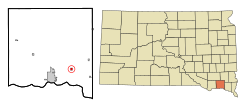
Pickstown is a town in southern Charles Mix County, South Dakota, United States. The population was 230 at the 2020 census. It was named after U.S. Army General Lewis A. Pick, former director of the Missouri River Office of the United States Army Corps of Engineers.

<span class="mw-page-title-main">Bradley, South Dakota</span> Town in South Dakota, United States

Bradley is a town in Clark County, South Dakota, United States. The population was 65 at the 2020 census.

<span class="mw-page-title-main">Florence, South Dakota</span> Town in South Dakota, United States

Florence is a town in northwestern Codington County, South Dakota, United States. It is part of the Watertown, South Dakota Micropolitan Statistical Area. The population was 337 at the 2020 census.

<span class="mw-page-title-main">Cresbard, South Dakota</span> Town in South Dakota, United States

Cresbard is a town in Faulk County, South Dakota, United States. The population was 96 at the 2020 census.

<span class="mw-page-title-main">Rockham, South Dakota</span> Town in South Dakota, United States

Rockham is a town in Faulk County, South Dakota, United States, off U.S. Route 212, and was a stop on the old Chicago and North Western Railway. The population was 22 at the 2020 census.

<span class="mw-page-title-main">Olivet, South Dakota</span> Town in South Dakota, United States

Olivet is a town in and the county seat of Hutchinson County, South Dakota. The population was 64 at the time of the 2020 census.

<span class="mw-page-title-main">Crooks, South Dakota</span> City in South Dakota, United States

Crooks is a city in Minnehaha County, South Dakota, United States and is a suburb of Sioux Falls. The population was 1,362 at the 2020 census. Crooks was named New Hope until 1904. The town's present name honors W. A. Crooks, a local politician.

<span class="mw-page-title-main">Wasta, South Dakota</span> Town in South Dakota, United States

Wasta(Lakota: wašté) is a town in Pennington County, South Dakota, United States, situated along the Cheyenne River. It had a population of 65 at the 2020 census.

<span class="mw-page-title-main">Peever, South Dakota</span> Town in South Dakota, United States

Peever is a town in Roberts County, South Dakota, United States. The population was 180 at the 2020 census.

<span class="mw-page-title-main">Doland, South Dakota</span> City in South Dakota, United States

Doland is a city in eastern Spink County, South Dakota, United States. The population was 199 at the 2020 census.

<span class="mw-page-title-main">Tulare, South Dakota</span> Town in South Dakota, United States

Tulare is a town in Spink County, South Dakota, United States. The population was 211 at the 2020 census.

<span class="mw-page-title-main">Mission, South Dakota</span> City in South Dakota, United States

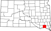
Mission is a city on the Rosebud Indian Reservation in northern Todd County, South Dakota, United States. The population was 1,156 at the 2020 census.

<span class="mw-page-title-main">Lowry, South Dakota</span> Town in South Dakota, United States

Lowry is a town in Walworth County, South Dakota, United States. The population was 10 at the 2020 census. The town is home to Lowry Pilgrim Community Church, Swan Creek Harness Shop, J & C Repair, Karst Service and a fire station. Lowry also has an abandoned school, and a post office, which closed to service in the early 1970s.

<span class="mw-page-title-main">Irene, South Dakota</span> City in South Dakota, United States

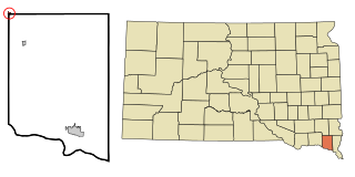
Irene is a city in Clay, Turner, and Yankton counties in South Dakota, United States. The population was 422 at the 2020 census. The portion of Irene that is located in Turner County is a part of the Sioux Falls, South Dakota metropolitan area, the portion located in Yankton County is part of the Yankton Micropolitan Statistical Area, and the portion located in Clay County is part of both the Vermillion Micropolitan Statistical Area and the Sioux City-Vermillion Combined Statistical Area. Irene is also host to the Irene Rodeo, held every summer.

References

  1. "SD Towns" (PDF). South Dakota State Historical Society. Archived from the original (PDF) on February 10, 2010. Retrieved February 14, 2010.
  2. "ArcGIS REST Services Directory". United States Census Bureau. Retrieved October 15, 2022.
  3. 1 2 U.S. Geological Survey Geographic Names Information System: Mission Hill, South Dakota
  4. 1 2 "Census Population API". United States Census Bureau. Retrieved October 15, 2022.
  5. 1 2 "U.S. Census website". United States Census Bureau . Retrieved January 31, 2008.
  6. "U.S. Census Bureau: Mission Hill town, South Dakota". www.census.gov. United States Census Bureau. Retrieved July 21, 2022.
  7. Federal Writers' Project (1940). South Dakota place-names, v.1-3. American guide series. University of South Dakota. p. 50.
  8. Chicago and North Western Railway Company (1908). A History of the Origin of the Place Names Connected with the Chicago & North Western and Chicago, St. Paul, Minneapolis & Omaha Railways. p. 103.
  9. "Yankton County". Jim Forte Postal History. Retrieved March 1, 2015.
  10. "US Gazetteer files 2010". United States Census Bureau. Archived from the original on February 20, 2011. Retrieved June 21, 2012.
  11. Farber, William O.; Geary, T. C.; Carlson, L. M. (1979). Government of South Dakota. Dakota Press. ISBN   0-88249-030-3. LCCN   78-31929.
  12. 1 2 "U.S. Census website". United States Census Bureau . Retrieved June 21, 2012.
  13. 1 2 U.S. Census Bureau. Census 2000. "QT-P1. Age Groups and Sex, Mission Hill, South Dakota". American FactFinder. <http://factfinder.census.gov>. Retrieved January 31, 2009.{{cite web}}: CS1 maint: numeric names: authors list (link)
  14. U.S. Census Bureau. Census 2000, Summary File 1. "GCT-PH1. Population, Housing Units, Area, and Density: 2000 - County -- Subdivision and Place". American FactFinder. <http://factfinder2.census.gov>. Retrieved January 31, 2008.{{cite web}}: CS1 maint: numeric names: authors list (link)
  15. 1 2 3 U.S. Census Bureau. Census 2000. "Census Demographic Profiles, Mission Hill, South Dakota" (PDF). CenStats Databases. Retrieved January 31, 2009.{{cite web}}: CS1 maint: numeric names: authors list (link)[ dead link ]