Mission San Cayetano de Calabazas

Last updated

Mission San Cayetano de Calabazas
San Cayetano de Calabazas.jpg
Ruins of the mission compound and church at Mission San Cayetano de Calabazas.
Locationnear Nogales, Arizona
Coordinates 31°27′09″N110°57′34″W / 31.452478°N 110.95957°W / 31.452478; -110.95957
Name as foundedLa Misión de San Cayetano de Calabazas
English translationThe Mission of Saint Cajetan of the Gourds
Patron Saint Cajetan
Founding date1756
Founding priest(s)Father Francisco Xavier Pauer
Built1756
Native tribe(s)
Spanish name(s)
Pima
Governing bodyPrivate
Current useHistorical Monument
DesignatedJune 3, 1971 [1]
Reference no.71000118
DesignatedDecember 14, 1990 [2]

Mission San Cayetano de Calabazas, also known as Calabasas, is a Spanish Mission in the Sonoran Desert, located near present-day Tumacacori, Arizona, United States.

Contents

History

18th century

The original San Cayetano mission at Tumacacori was founded by Eusebio Kino in 1691, on Kino's first major exploration trip into the Pimeria Alta. During the O'odham rebellion of 1751, this mission was destroyed.[ citation needed ]

In 1756, Francisco Xavier Pauer re-established the mission, taking at least seventy-eight O'odham from their village of Toacuquita near the Santa Cruz River.[ citation needed ] He performed the mission's first baptism on April 20, 1756. [3] On November 1 of the same year, Pauer relocated the mission to the south, putting it on the bluffs to the east of the Santa Cruz, upstream of the confluence with Sonoita Creek. [4] [5] [3]

By May 1761, a report said the mission had a house with a lock and a half-built church. [3] A church report in 1772 described the mission as having a population 64: 21 men, 24 women and 19 children. It described the location as being on an open plain with good lands, but that the Indians do little or no farming, and that there was no church or house for the missionary. However by 1773 the church was functional and in 1775, Pedro Font said mass there during the first Juan Bautista de Anza expedition to the upper part of Las Californias. [4] [5]

In 1777, the mission church, houses and the granary filled with maize, were sacked and set afire during a raid by part of a band of Apache, apostate O’odham, and Seris that had similarly attacked Magdalena and other Pimería Alta communities during 1776. The mission O’odham killed 14 of the raiders but lost 7 of their own. The Mission was abandoned in 1786 when the last of the O'odham left because of continuing hostilities by the Apaches. [4] [5]

19th century

Between 1807 and 1830 the settlement area was used as an estancia (farm) for nearby Mission San José de Tumacácori. In 1808, Spanish settlers and Christian Indians moved into the Calabazas area and restored the chapel. In response, the Apaches again attacked in 1830, setting fire to the buildings and carrying off sacred vessels and vestments in the process. This discouraged anyone from living there for more than two decades, but vaqueros from Tumacácori continued to run cattle in the vicinity.

In 1837, the Mexican government built Presidio de Calabasas to protect the area. In 1844, Mission Calabasas and its lands were sold at auction to the brother-in-law of Sonoran governor Manuel María Gándara. Gandara established a rancho at the old mission stocked with 6,000 cattle. The 1854 Gadsden Purchase, of land by the U.S. from México, included this area in New Mexico Territory. Mexican Army soldiers, in the Tucson garrison to protect the citizens from Apaches, withdrew from the Gadsden Purchase territory early in 1856. With their withdrawal the Gándara ranch came to an end.

Late in 1856, the Mission church, now ranch house, became the temporary home of Major Enoch Steen, commander of four companies of the First Regiment of United States Dragoons who established Camp Moore, at the former Presidio de Calabasas, as the first military post in the New Mexico Territory’s Gadsden Purchase area. [5] Ignacio Pesqueira, the new governor of Sonora, allowed quartermaster wagons to cross into Sonora for supplies. Now with the arrival of military protection, the Gandara ranch, and the surrounding area filled with American squatters. The following year, Steen received orders from Colonel Benjamin Bonneville, the departmental commander in Santa Fe, to move closer to Tucson. Regarding the vices of Tucson as a danger to the good order and discipline of his troops, Steen instead moved his camp 25 miles northeast to the headwaters of Sonoita Creek. The new post was named Fort Buchanan in honor of the recently inaugurated President James Buchanan. [6] Subsequently, the former mission buildings served a number of purposes, a customs house in 1857 and the ranch house was occupied by family of Larcena Pennington Page before September 1859. [5] [7]

In September 1865 the Union Army garrison at Tubac, Arizona was transferred to Old Camp Moore at Calabasas and it was first named Post at Calabasas then Fort Mason in honor of General Mason, who was then the commander of the California Volunteers in Arizona. The 1st Battalion of Native Cavalry, California Volunteers and 7th Regiment California Volunteer Infantry occupied the post until they were relieved by troops of the United States Army in May 1866. Due to persistent malaria, the Regulars abandoned the fort in October 1866 and established Camp Cameron.

Mission Calabazas was a completely abandoned ruin by 1878, with only a roofless shell remaining.

Preservation

Father Norman Whalen recruited preservation volunteers who capped the adobe walls, and placed a concrete foundation in 1960. The Arizona Historical Society took over site management and ownership in October 1974. The Mission became part of Tumacácori National Historical Park in 1990. [8]

It was declared a National Historic Landmark in 1990, and is on the National Register of Historic Places. [2] [9]

See also

Related Research Articles

<span class="mw-page-title-main">Mission San Xavier del Bac</span> 17th-century Spanish mission in Arizona

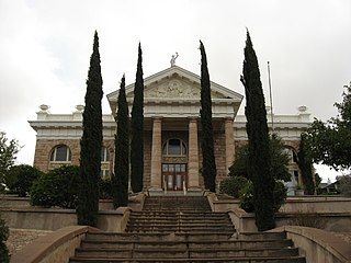
Mission San Xavier del Bac is a historic Spanish Catholic mission located about 10 miles (16 km) south of downtown Tucson, Arizona, on the Tohono O'odham Nation San Xavier Indian Reservation. The mission was founded in 1692 by Padre Eusebio Kino in the center of a centuries-old settlement of the Sobaipuri O'odham, a branch of the Akimel or River O'odham located along the banks of the Santa Cruz River. The mission was named for Francis Xavier, a Christian missionary and co-founder of the Society of Jesus in Europe. The original church was built to the north of the present Franciscan church. This northern church or churches served the mission until it was razed during an Apache raid in 1770.

<span class="mw-page-title-main">Santa Cruz County, Arizona</span> County in Arizona, United States

Santa Cruz is a county in southern Arizona, United States. As of the 2020 census, the population is 47,669. The county seat is Nogales. The county was established in 1899. It borders Pima County to the north and west, Cochise County to the east, and the Mexican state of Sonora to the south.

<span class="mw-page-title-main">Patagonia, Arizona</span> Town in Arizona, United States

Patagonia is a town in Santa Cruz County, Arizona, United States. As of the 2010 census it had a population of 913. It developed in the mid-19th century as a trading and supply center for nearby mines and ranches. In the 21st century, it is a tourist destination, retirement community, and arts and crafts center.

<span class="mw-page-title-main">Tumacacori, Arizona</span> Historic community in Santa Cruz County, Arizona

Tumacacori is an unincorporated community in Santa Cruz County, Arizona, United States, which abuts the community of Carmen. Together, the communities constitute the Tumacacori-Carmen census-designated place (CDP). The population of the CDP was 393 at the 2010 census.

<span class="mw-page-title-main">Pimería Alta</span> Viceroyalty of New Spain area now called Pimeria Alta

The Pimería Alta was an area of the 18th century Sonora y Sinaloa Province in the Viceroyalty of New Spain, that encompassed parts of what are today southern Arizona in the United States and northern Sonora in Mexico.

<span class="mw-page-title-main">Eusebio Kino</span> German-Italian Jesuit missionary (1645–1711)

Father Eusebio Francisco Kino, SJ, often referred to as Father Kino, was an Italian Jesuit, missionary, geographer, explorer, cartographer, mathematician and astronomer born in the Territory of the Bishopric of Trent, then part of a partially German-speaking area of the Holy Roman Empire of the German Nation. For the last 24 years of his life he worked in the region then known as the Pimería Alta, modern-day Sonora in Mexico and southern Arizona in the United States. He explored the region and worked with the indigenous Native American population, including primarily the Tohono O'Odham, Sobaipuri and other Upper Piman groups. He proved that the Baja California Territory was not an island but a peninsula by leading an overland expedition there. By the time of his death he had established 24 missions and visitas.

<span class="mw-page-title-main">Tumacácori National Historical Park</span> National Historical Park in Santa Cruz County, Arizona

Tumacácori National Historical Park is located in the upper Santa Cruz River Valley in Santa Cruz County, southern Arizona. The park consists of 360 acres (1.5 km2) in three separate units. The park protects the ruins of three Spanish mission communities, two of which are National Historic Landmark sites. It also contains the landmark 1937 Tumacácori Museum building, also a National Historic Landmark.

<span class="mw-page-title-main">Spanish missions in the Sonoran Desert</span> 17th to 19th-century Catholic religious outposts

The Spanish missions in the Sonoran Desert are a series of Jesuit Catholic religious outposts established by the Spanish Catholic Jesuits and other orders for religious conversions of the Pima and Tohono O'odham indigenous peoples residing in the Sonoran Desert. An added goal was giving Spain a colonial presence in their frontier territory of the Sonora y Sinaloa Province in the Viceroyalty of New Spain, and relocating by Indian Reductions settlements and encomiendas for agricultural, ranching, and mining labor.

<span class="mw-page-title-main">Mission San José de Tumacácori</span> 19th-century Franciscan mission in Arizona

Mission San José de Tumacácori is a historic Spanish mission near Nogales, Arizona, preserved in its present form by Franciscans in 1828.

<span class="mw-page-title-main">Tubac Presidio State Historic Park</span> Park in Santa Cruz County, Arizona

Tubac Presidio State Historic Park, located in Tubac, Arizona, US, preserves the ruins of the Presidio San Ignacio de Tubac and various other buildings, thereby presenting a timeline of European settlement in this Southern Arizona town. The park contains a museum, a number of historic sites, an underground archeology exhibit displaying the excavated foundations of the Tubac Presidio, and a picnic area. Various cultural events are held on-site throughout the year, including Anza Days (October), Los Tubaqueños living history presentations, archeological tours, and nature walks. Until recently, the park was administered by Arizona State Parks but is the first park in the Arizona state park system. As a result of budget cutbacks, the Tubac Presidio was scheduled to be closed in 2010, but was rescued by local residents and the Tubac Historical Society. It is now operated by The Friends of the Presidio and staffed with dedicated volunteers.

<span class="mw-page-title-main">Mission Los Santos Ángeles de Guevavi</span> Historic mission ruins in Arizona

La Misión de San Gabriel de Guevavi was founded by Jesuit missionary priests Eusebio Kino and Juan María de Salvatierra in 1691. Subsequent missionaries called it San Rafael and San Miguel, resulting in the common historical name of Mission Los Santos Ángeles de Guevavi.

The Sobaipuri were one of many indigenous groups occupying Sonora and what is now Arizona at the time Europeans first entered the American Southwest. They were a Piman or O'odham group who occupied southern Arizona and northern Sonora in the 15th–19th centuries. They were a subgroup of the O'odham or Pima, surviving members of which include the residents of San Xavier del Bac which is now part of the Tohono O'odham Nation and the Akimel O'odham.

<span class="mw-page-title-main">Presidio Santa Cruz de Terrenate</span> Spanish-era fortress in Cochise County, Arizona, United States

The Presidio Santa Cruz de Terrenate is a former Spanish military presidio, or fortress, located roughly west of the town of Tombstone, Arizona, in the United States of America.

<span class="mw-page-title-main">Atascosa Mountains</span> Landform in Santa Cruz County, Arizona

The Atascosa Mountains is a mountain range in western Santa Cruz County, Arizona, United States. It is sandwiched between the larger Tumacacori Mountains to the north, and a small east–west border range to the south, the Pajarito Mountains; the Pajaritos are on the U.S.–Mexico border and abut the Sierra La Esmeralda range in northern Sonora.

The Sierra La Esmeralda range, are a mountain range in northern Sonora, Mexico at the northern region of the Sierra Madre Occidental cordillera. The region contains sky island mountain ranges, called the Madrean Sky Islands, some separated from the Sierra Madre Occidental proper, and occurring in the northeastern Sonoran Desert, and extreme west-northwestern Chihuahuan Desert. Many of the ranges occur in southeast Arizona.

The Presidio de Calabasas, also known as Fort Calabasas or Camp Calabasas, was a stone fortress built by Mexico in 1837 south of Tumacacori, Arizona. It was built on the land of the Grant of Manuel María Gándara, by Gándara to protect his lands near the Mission San Cayetano de Calabazas from the Apache. Civilians established a small farming settlement called Calabasas, in the area nearby the protection of the Presidio.

<span class="mw-page-title-main">Calabasas, Arizona</span> Ghost town in Santa Cruz County, Arizona, US

Calabasas is a former populated place or ghost town, within the Census-designated place of Rio Rico, a suburb of Nogales in Santa Cruz County, Arizona.

Between the years of 1539 and 1821, the Spanish Empire explored, colonized, and ruled over what is the state of Arizona in the United States.

References

  1. "National Register Information System". National Register of Historic Places . National Park Service. January 23, 2007.
  2. 1 2 "San Cayetano de Calabazas". National Historic Landmark summary listing. National Park Service. Archived from the original on March 3, 2009. Retrieved September 27, 2007.
  3. 1 2 3 Stockel, Henrietta (September 15, 2022). Salvation Through Slavery: Chiricahua Apaches and Priests on the Spanish Colonial Frontier. University of New Mexico Press. ISBN   978-0-8263-4327-7.
  4. 1 2 3 San Cayetano de Calabazas from nps.gov accessed July 19, 2019
  5. 1 2 3 4 5 San Cayetano de Calabazas from southwestmissions.org accessed July 20, 2019
  6. United States Militart Posts on the Mexico Border (1856 to Present) from archaeologysouthwest.org accessed July 21, 2019
  7. Forbes, Robert Humphrey. "Penningtons, Pioneers of Early Arizona" (PDF). Retrieved February 21, 2015.
  8. "San Cayetano de Calabazas / Calabasas—Accompanying rendering from 1853 and 7 photos from 1913, 1934, and 1990" (pdf). National Register of Historic Places Registration. National Park Service. March 8, 1990.
  9. Mark R. Barnes (March 8, 1990). "San Cayetano de Calabazas / Calabasas" (pdf). National Register of Historic Places Registration. National Park Service.