Monticello, Green County, Wisconsin

Last updated

Monticello, Wisconsin
MonticelloWI Panorama.jpg
Historic plaques in Monticello
Green County Wisconsin Incorporated and Unincorporated areas Monticello Highlighted.svg
Location of Monticello in Green County, Wisconsin.
Coordinates: 42°44′55″N89°35′31″W / 42.74861°N 89.59194°W / 42.74861; -89.59194
Country Flag of the United States.svg  United States
State Flag of Wisconsin.svg  Wisconsin
Counties Green
Area
[1]
  Total1.21 sq mi (3.13 km2)
  Land1.19 sq mi (3.09 km2)
  Water0.02 sq mi (0.04 km2)
Elevation
[2]
837 ft (255 m)
Population
 (2010) [3]
  Total1,217
  Estimate 
(2019) [4]
1,202
  Density1,008.39/sq mi (389.18/km2)
Time zone UTC-6 (Central (CST))
  Summer (DST) UTC-5 (CDT)
Area code 608
FIPS code 55-54000 [5]
GNIS feature ID1583746 [2]
Website http://www.monticello-wi.com

Monticello is a village in Green County, Wisconsin, United States. The population was 1,217 as of the 2010 census.

Contents

Geography

According to the United States Census Bureau, the village has a total area of 1.18 square miles (3.06 km2), of which, 1.17 square miles (3.03 km2) of it is land and 0.01 square miles (0.03 km2) is water. [6]

Demographics

Historical population
CensusPop.Note
1880 156
1890 407160.9%
1900 55937.3%
1910 67120.0%
1920 6770.9%
1930 644−4.9%
1940 71611.2%
1950 79210.6%
1960 789−0.4%
1970 87010.3%
1980 1,02117.4%
1990 1,14011.7%
2000 1,1460.5%
2010 1,2176.2%
2019 (est.)1,202 [4] −1.2%
U.S. Decennial Census [7]

2010 census

As of the census [3] of 2010, there were 1,217 people, 538 households, and 321 families living in the village. The population density was 1,040.2 inhabitants per square mile (401.6/km2). There were 566 housing units at an average density of 483.8 per square mile (186.8/km2). The racial makeup of the village was 97.5% White, 0.2% African American, 0.1% Native American, 0.8% Asian, 0.6% from other races, and 0.9% from two or more races. Hispanic or Latino of any race were 2.0% of the population.

There were 538 households, of which 32.2% had children under the age of 18 living with them, 46.3% were married couples living together, 8.7% had a female householder with no husband present, 4.6% had a male householder with no wife present, and 40.3% were non-families. 33.1% of all households were made up of individuals, and 11.8% had someone living alone who was 65 years of age or older. The average household size was 2.26 and the average family size was 2.91.

The median age in the village was 39.2 years. 24.8% of residents were under the age of 18; 6.7% were between the ages of 18 and 24; 26.6% were from 25 to 44; 28.5% were from 45 to 64; and 13.4% were 65 years of age or older. The gender makeup of the village was 48.0% male and 52.0% female.

2000 census

As of the census [5] of 2000, there were 1,146 people, 498 households, and 310 families living in the village. The population density was 983.7 people per square mile (381.4/km2). There were 517 housing units at an average density of 443.8/sq mi (172.1/km2). The racial makeup of the village was 98.52% White, 0.09% African American, 0.17% Native American, 0.09% Asian, 0.52% from other races, and 0.61% from two or more races. Hispanic or Latino of any race were 1.05% of the population.

There were 498 households, out of which 28.7% had children under the age of 18 living with them, 53.2% were married couples living together, 6.0% had a female householder with no husband present, and 37.6% were non-families. 32.9% of all households were made up of individuals, and 15.1% had someone living alone who was 65 years of age or older. The average household size was 2.30 and the average family size was 2.95.

In the village, the population was spread out, with 24.3% under the age of 18, 7.6% from 18 to 24, 28.1% from 25 to 44, 24.6% from 45 to 64, and 15.4% who were 65 years of age or older. The median age was 39 years. For every 100 females, there were 96.9 males. For every 100 females age 18 and over, there were 93.1 males.

The median income for a household in the village was $44,087, and the median income for a family was $54,464. Males had a median income of $35,921 versus $22,688 for females. The per capita income for the village was $21,772. About 2.7% of families and 5.8% of the population were below the poverty line, including 8.3% of those under age 18 and 6.7% of those age 65 or over.

Media

The Post Messenger Recorder is the area's weekly newspaper.

Notable people

Education

Monticello High School is the area's high school.

Related Research Articles

<span class="mw-page-title-main">Fall River, Wisconsin</span> Village in Wisconsin, United States

Fall River is a village in Columbia County, Wisconsin, United States, along the North Fork of the Crawfish River. The population was 1,712 at the 2010 census. It is part of the Madison Metropolitan Statistical Area.

<span class="mw-page-title-main">Neosho, Wisconsin</span> Village in Wisconsin, United States

Neosho is a village in Dodge County, Wisconsin, United States. The population was 574 at the 2010 census.

<span class="mw-page-title-main">Brandon, Wisconsin</span> Village in Wisconsin, United States

Brandon is a village in Fond du Lac County, Wisconsin, United States. The population was 879 at the 2010 census.

<span class="mw-page-title-main">Monticello, Lafayette County, Wisconsin</span> Town in Wisconsin, United States

Monticello is a town in Lafayette County, Wisconsin, United States. The population was 133 at the 2010 census.

<span class="mw-page-title-main">Weyerhaeuser, Wisconsin</span> Village in Wisconsin, United States

Weyerhaeuser is a village in Rusk County, Wisconsin, United States. The population was 238 at the 2010 census.

<span class="mw-page-title-main">Chaseburg, Wisconsin</span> Village in Wisconsin, United States

Chaseburg is a village in Vernon County, Wisconsin, United States. The population was 284 at the 2010 census.

Whitewater is a town in Walworth County, Wisconsin, United States. The population was 1,433 at the 2020 census.

<span class="mw-page-title-main">Newburg, Wisconsin</span> Village in Ozaukee and Washington counties, Wisconsin

Newburg is a village in Ozaukee and Washington counties in the U.S. state of Wisconsin. The population was 1,254 at the 2010 census. Of this, 1,157 were in Washington County, and only 97 were in Ozaukee County.

<span class="mw-page-title-main">Cazenovia, Wisconsin</span> Village in Wisconsin, United States

Cazenovia is a village in Richland and Sauk Counties in the U.S. state of Wisconsin. The population was 318 at the 2010 census. Of this, 314 were in Richland County, and only 4 were in Sauk County.

<span class="mw-page-title-main">Barron, Wisconsin</span> City in Wisconsin, United States

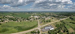
Barron is a city in Barron County, in the U.S. state of Wisconsin. The population was 3,733 at the 2020 census. The city is surrounded by the Town of Barron.

<span class="mw-page-title-main">Alma, Wisconsin</span> City in Wisconsin, United States

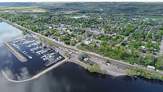
Alma is a city in and the county seat of Buffalo County, Wisconsin, United States. The population was 716 at the 2020 census.

<span class="mw-page-title-main">Wauzeka, Wisconsin</span> Village in Wisconsin, United States

Wauzeka is a village in Crawford County, Wisconsin, United States. The population was 628 at the 2020 census. The village is located within the Town of Wauzeka near the confluence of the Kickapoo River and Wisconsin River.

<span class="mw-page-title-main">Windsor, Wisconsin</span> Village in Wisconsin, United States

Windsor is a village and former town in Dane County, Wisconsin. The population was 8,754 at the time of the 2020 census. The communities of Lake Windsor, Morrisonville, and Token Creek are located within the village. Windsor voted to incorporate as a village on November 3, 2015; prior to its incorporation, it was a town, and a portion of the town was a census-designated place. Windsor is a part of the Census Bureau's Madison metropolitan statistical area.

<span class="mw-page-title-main">Fennimore, Wisconsin</span> City in Wisconsin, United States

Fennimore is a city in Grant County, Wisconsin, United States. The population was 2,497 at the 2010 census. The city's area was separated from the Town of Fennimore, which remains as an adjacent rural area.

<span class="mw-page-title-main">Melrose (town), Wisconsin</span>

Melrose is a town in Jackson County, Wisconsin, United States. The population was 402 at the 2000 census. The Village of Melrose is located within the town.

<span class="mw-page-title-main">Pepin, Wisconsin</span> Village in Wisconsin, United States

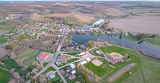
Pepin is a village in Pepin County, Wisconsin, United States. The population was 837 at the 2010 census. The village is located within the Town of Pepin.

<span class="mw-page-title-main">Milltown, Wisconsin</span> Village in Wisconsin, United States

Milltown is a village in Polk County, Wisconsin, United States. The population was 917 at the 2010 census. The village is located within the Town of Milltown.

<span class="mw-page-title-main">Rochester, Wisconsin</span> Village in Wisconsin

Rochester is a village in Racine County, Wisconsin, United States. The population was 3,785 at the 2020 census. The village is located within the former Town of Rochester. On November 4, 2008, the village of Rochester voted to consolidate with the Town of Rochester.

<span class="mw-page-title-main">Darien, Wisconsin</span> Village in Wisconsin, United States

Darien is a village in Walworth County, Wisconsin, United States. The population was 1,573 at the 2020 census. The village is located within the Town of Darien.

<span class="mw-page-title-main">Waupaca, Wisconsin</span> City in Wisconsin, United States

Waupaca is a city in and the county seat of Waupaca County in the U.S. state of Wisconsin. The population was 6,282 at the 2020 census.

References

  1. "2019 U.S. Gazetteer Files". United States Census Bureau. Retrieved August 7, 2020.
  2. 1 2 "US Board on Geographic Names". United States Geological Survey. October 25, 2007. Retrieved January 31, 2008.
  3. 1 2 "U.S. Census website". United States Census Bureau . Retrieved November 18, 2012.
  4. 1 2 "Population and Housing Unit Estimates". United States Census Bureau. May 24, 2020. Retrieved May 27, 2020.
  5. 1 2 "U.S. Census website". United States Census Bureau . Retrieved January 31, 2008.
  6. "US Gazetteer files 2010". United States Census Bureau. Archived from the original on July 2, 2012. Retrieved November 18, 2012.
  7. "Census of Population and Housing". Census.gov. Retrieved June 4, 2015.
  8. 'Wisconsin Blue Book 1873,' Biographical Sketch of Orrin Bacon, pg. 435
  9. Wisconsin Blue Book, 1923. Legislative Reference Bureau. 1923. p. 615.
  10. 'Wisconsin Blue Book 1948,' Biographical Sketch of Ray H. Schoonover, pg. 50
  11. "Stauffer, Christ M. 1896". Wisconsin Historical Society. Retrieved October 21, 2011.