
Test Valley is a local government district with borough status in Hampshire, England, named after the valley of the River Test. The council is based in the borough's largest town of Andover. The borough also contains the town of Romsey and numerous villages and surrounding rural areas. A small part of the borough at its southern end lies within the New Forest National Park, and part of the borough north of Andover lies within the North Wessex Downs, a designated Area of Outstanding Natural Beauty.
Silverstone is a village and civil parish in Northamptonshire, England. It is about four miles from Towcester on the former A43 main road, 10 miles (16 km) from the M1 motorway junction 15A and about 12 miles (19 km) from the M40 motorway junction 10, Northampton, Milton Keynes and Banbury. The population of the civil parish at the 2011 census was 2,176. The A43 now bypasses to the south-east of the village.

In England, a civil parish is a type of administrative parish used for local government. It is a territorial designation which is the lowest tier of local government. Civil parishes can trace their origin to the ancient system of parishes, which for centuries were the principal unit of secular and religious administration in most of England and Wales. Civil and religious parishes were formally split into two types in the 19th century and are now entirely separate. Civil parishes in their modern form came into being through the Local Government Act 1894, which established elected parish councils to take on the secular functions of the parish vestry.
Broughton is a town and civil parish situated on the Roman Ermine Street, in the North Lincolnshire district of Lincolnshire, England. The population of the civil parish at the 2011 census was 5,726. In 2021, the population was 5,434. It is situated approximately 2 miles (3 km) north-west from the town of Brigg. The hamlets of Wressle, Castlethorpe, and part of Scawby Brook lie within the parish boundaries.

A civil parish is a country subdivision, forming the lowest unit of local government in England. There are 333 civil parishes in the ceremonial county of Cheshire, most of the county being parished. Cheshire East unitary authority is entirely parished. At the 2001 census, there were 565,259 people living in 332 parishes, accounting for 57.5 per cent of the county's population.

Ashby with Scremby is a civil parish in the East Lindsey district of Lincolnshire, England, with a population of 147, increasing to 179 at the 2011 census. The parish includes the village of Scremby, along with the hamlets of Ashby by Partney and Grebby.

Buckland is a village and civil parish in the East Hertfordshire district of Hertfordshire, England. The village is situated on the A10 road, with the market town of Royston situated 41⁄2 miles north and Buntingford 3 miles south. According to the 2011 census, the parish of Buckland, including the hamlet of Chipping has a population of 274.
The wards and electoral divisions in the United Kingdom are electoral districts at sub-national level, represented by one or more councillors. The ward is the primary unit of English electoral geography for civil parishes and borough and district councils, the electoral ward is the unit used by Welsh principal councils, while the electoral division is the unit used by English county councils and some unitary authorities. Each ward/division has an average electorate of about 5,500 people, but ward population counts can vary substantially. As of 2021 there are 8,694 electoral wards/divisions in the UK. An average area of wards or electoral divisions in the United Kingdom is 28.109 km2 (10.853 sq mi).

Hulme Walfield is a small village and civil parish, just north of Congleton, in the unitary authority of Cheshire East and the ceremonial county of Cheshire. It is home to most of Westlow Mere. According to the 2001 census, the population of the civil parish was 140, increasing slightly to 148 at the 2011 Census

Fyfield is a village and civil parish in the Test Valley district of north-west Hampshire, England.

Hassall is a village and civil parish in the Borough of Cheshire East and the ceremonial county of Cheshire, England. The civil parish contains the very small hamlet of Day Green. According to the 2001 United Kingdom census, the population was 281, reducing to 265 at the 2011 Census.

Somerford Booths is a small civil parish in the unitary authority of Cheshire East and the ceremonial county of Cheshire, England. In the census of 2001 it was recorded as having a population of 175. increasing to 181 at the 2011 Census. The civil parish holds a parish council meeting under a grouping scheme with the civil parish of Hulme Walfield, and so it is consequently called Hulme Walfield & Somerford Booths Parish Council. The parish is small and now consists of scattered farms and small groupings of houses, including the hamlet of Newsbank. It contains Somerford Booths Hall as well as Grove House Farm and Broomfield Farm which are shown as ancient buildings on the Ordnance Survey map of the area.

Hampton is a former civil parish, now in the parishes of No Mans Heath and District and Malpas, in the unitary authority of Cheshire West and Chester and the ceremonial county of Cheshire, England. According to the 2001 UK census, the total population of the civil parish was 409, decreasing marginally to 405 at the 2011 Census. The parish included Hampton Green. Hampton was formerly a township in the parish of Malpas, in 1866 Hampton became a separate civil parish, on 1 April 2015 the parish was abolished to form "No Man's Heath and District", part of it also went to Malpas.

Snelson is a former civil parish, now in the parish of Peover Superior and Snelson, in the Borough of Cheshire East and ceremonial county of Cheshire in England. In 2001 it had a population of 157, rising marginally to 161 at the 2011 Census.

A civil parish is a country subdivision, forming the lowest unit of local government in England. There are 218 civil parishes in the ceremonial county of Cornwall, which includes the Isles of Scilly. The county is effectively parished in its entirety; only the unpopulated Wolf Rock is unparished. At the 2001 census, there were 501,267 people living in the current parishes, accounting for the whole of the county's population. The final unparished areas of mainland Cornwall, around St Austell, were parished on 1 April 2009 to coincide with the structural changes to local government in England.
Red Post Bridge is a small village in the civil parish of Monxton in the Test Valley district of Hampshire, England. Its nearest town is Andover, which lies approximately 2.75 miles north-east from the village.
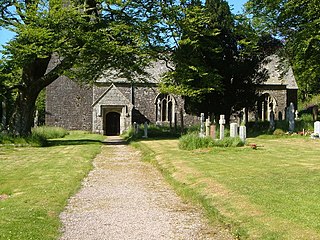
Harford is a hamlet and civil parish located approximately 2 miles (3.2 km) north of the town of Ivybridge in the county of Devon, England. The parish lies in the local government district of the South Hams, which is a localised, second-tier governmental division of the non-metropolitan county of Devon, administered by Devon County Council.


