
St. Clair County is the ninth most populous county in Illinois. Located directly east of St. Louis, the county is part of the Metro East region of the Greater St. Louis metropolitan area in southern Illinois. As of the 2020 United States census, St. Clair County had a population of 257,400, making it the third most populous county in Illinois outside the Chicago metropolitan area. Belleville is the county’s seat and largest city.

Greenville is a city in the Lower Peninsula of the U.S. state of Michigan. With a population 8,816 at the 2020 census, it is the largest city in Montcalm County. The city is the location of the establishment of the Meijer chain of stores.

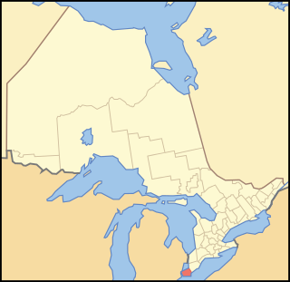
Port Huron is a city in the U.S. state of Michigan and the county seat of St. Clair County. The population was 28,983 at the 2020 census. The city is bordered on the west by Port Huron Township, but the two are administered autonomously.
Essex County is a primarily rural county in Southwestern Ontario, Canada comprising seven municipalities: Amherstburg, Kingsville, Lakeshore, LaSalle, Leamington, Tecumseh and the administrative seat, Essex.

St. Clair is a township in southwestern Ontario, Canada, immediately south of Sarnia in Lambton County, along the eastern shores of the St. Clair River.
The Thumb is a region and a peninsula of the U.S. state of Michigan, so named because the Lower Peninsula is shaped like a mitten. The Thumb area is generally considered to be in the Central Michigan region, east of the Tri-Cities and north of Metro Detroit. The region is also branded as the Blue Water Area.

Bathurst Street is a main north–south thoroughfare in Toronto, Ontario, Canada. It begins at an intersection of the Queens Quay roadway, just north of the Lake Ontario shoreline. It continues north through Toronto to the Toronto boundary at Steeles Avenue. It is a four-lane thoroughfare throughout Toronto. The roadway continues north into York Region where it is known as York Regional Road 38.

Peterston-super-Ely is a village and community situated on the River Ely in the county borough of the Vale of Glamorgan, Wales. The community population at the 2011 census was 874. The community includes the hamlet of Gwern-y-Steeple.

Augusta Township is a township in the United Counties of Leeds and Grenville, located in eastern Ontario, Canada. Augusta is situated along the Saint Lawrence River, and extends back into rural hamlets. The township is located between the city of Brockville to the west, and the town of Prescott to the east.

Abbey St Bathans is a parish in the Lammermuir district of Berwickshire, in the eastern part of the Scottish Borders. Unique in its topography, it is situated in a long winding steep wooded valley that follows the Whiteadder Water. The parish had a population of 106 at the 2011 Census.

Welsh settlement in the Americas was the result of several individual initiatives to found distinctively Welsh settlements in the New World. It can be seen as part of the more general British colonization of the Americas.
The St. Clair Parkway, historically referred to as the River Road, is a scenic parkway in the Canadian province of Ontario. It travels alongside the St. Clair River from west of Wallaceburg to Sarnia, a distance of 41.8 kilometres (26.0 mi). It formed a portion of the route of Highway 40 until it was bypassed by an inland route that opened in the mid-1970s. The St. Clair River Parkway Commission maintained the route from 1966 until 2006, when it was disbanded and responsibility over the parkway transferred to Chatham-Kent and Lambton County, both of which designate the route as County Road 33. The communities of Port Lambton, Sombra, Courtright, Mooretown, Corunna and Froomfield are located along the parkway, all early settlements of the 19th century.
As with other towns and cities in Ireland, Letterkenny has a history of great architecture. Many examples of ancient architecture remain in the town to the present day – though much has been lost also, through decay and modern development.

The Eliphalet Austin House is a historic residence in the community of Austinburg, Ohio, United States. Constructed by the community's namesake founder, it has been greatly modified by later owners, and it has been named a historic site.

Steeple Morden is a village and civil parish in Cambridgeshire, England, about 15 miles (24 km) south west of Cambridge and 5 miles (8 km) west of Royston. It is part of the South Cambridgeshire local government district.
Heritage Village Museum is a recreated 1800s community in Southwestern Ohio, in the United States. The village contains 13 historic buildings from around the Cincinnati area; they were moved here to save them from destruction. The village is located within Sharon Woods Park in Sharonville, Ohio.

The Bethel Methodist Episcopal Church is located west of Pleasant City, Ohio on SR 146. The church was placed on the National Register of Historic Places on November 24, 1978.

Holy Rosary Catholic Church is a Roman Catholic parish on the east side of St. Marys, Ohio, United States. Established in 1852, the church has been recognized for its historic 1860s church building, which was demolished amid a period of growth in the 1970s and replaced with a modernist structure.

St Andrews Anglican Church is a heritage-listed churchyard at 160 Vulture Street, South Brisbane, City of Brisbane, Queensland, Australia. It was designed by Andrea Stombuco and built from 1878 to 1932. It was added to the Queensland Heritage Register on 21 October 1992.

St James' Anglican Church is a heritage-listed Anglican church precinct at 19 Tank Street, Morpeth, City of Maitland, New South Wales, Australia. The original design was attributed to Edward Charles Close, with later additions by Edmund Blacket and John Horbury Hunt and built from 1837 to 1875 by Edward Charles Close and James Sherwood. The precinct also includes the St. James' rectory and parish hall. The property is vested in the trustees of church property for the Diocese of Newcastle. It was added to the New South Wales State Heritage Register on 27 January 2017.

