Related Research Articles

Doniphan County is the most northeastern county in the U.S. state of Kansas. Its county seat is Troy, and its most populous city is Wathena. As of the 2020 census, the county population was 7,510. The county was named after Alexander Doniphan, a Mexican–American War hero. It is bounded on the east by the Missouri river, south by Atchison county, and west by Brown county.
East Randolph is a hamlet, census-designated place, and former village in Cattaraugus County, New York, United States. The population was 620 at the 2010 census. East Randolph is adjacent to the northeast part of the former village of Randolph and is mostly within the town of Randolph, with a small part inside the town of Conewango. Their area code is 716.
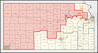
Kansas's 1st congressional district is a congressional district in the U.S. state of Kansas. Commonly known as "The Big First", the district encompasses all or part of 60 counties spanning more than half of the state, making it the seventh-largest district in the nation that does not cover an entire state.
Eden is an unincorporated community in Atchison County, Kansas, United States. It is about 5 miles west and 5 miles north of Atchison. It lies at the present-day intersection of Labette Rd, 322nd Rd, and 326th Rd.

Doniphan is an unincorporated community in Doniphan County, Kansas, United States.

The Iowa Reservation of the Iowa Tribe of Kansas and Nebraska straddles the borders of southeast Richardson County in southeastern Nebraska and Brown and Doniphan counties in northeastern Kansas. Tribal headquarters are west of White Cloud, Kansas. The reservation was defined in a treaty from March 1861. As of 2023, the tribe operates Casino White Cloud on the reservation.

Iowa Point is an unincorporated community in northeastern Doniphan County, Kansas, United States.
Walsh is an unincorporated community located in the town of Porterfield, in Marinette County, Wisconsin, United States.
Medina is an unincorporated community in Jefferson County, Kansas, United States.
Monrovia is an unincorporated community in Atchison County, Kansas, United States. Monrovia is located at 39°31′27″N95°20′46″W.
Parnell is an unincorporated community in Atchison County, Kansas, United States.
Shannon is an unincorporated community in Atchison County, Kansas, United States.
Mercier is an unincorporated community in Mission Township, Brown County, Kansas, United States.
Brenner is an unincorporated community in Wayne Township, Doniphan County, Kansas, United States.
Palermo is an unincorporated community in Doniphan County, Kansas, United States.
Blair is an unincorporated community in Doniphan County, Kansas, United States.
Boyle is an unincorporated community in Jefferson County, Kansas, United States.
Black Jack is an unincorporated community in Douglas County, Kansas, United States.
Geary is a ghost town in Wayne Township, Doniphan County, Kansas, United States.
Smyrna is an unincorporated community in Freeport Township, Harrison County, in the U.S. state of Ohio. Smyrna is located in southeast Freeport Township next to the southern boundary of the township and county.
References
- ↑ "Moray, Kansas", Geographic Names Information System , United States Geological Survey, United States Department of the Interior
- ↑ Blackmar, Frank Wilson (1912). Kansas: A Cyclopedia of State History, Volume 2. Standard Publishing Company. pp. 311.
- ↑ "Kansas Post Offices, 1828-1961 (archived)". Kansas Historical Society. Archived from the original on October 9, 2013. Retrieved June 8, 2014.
{{cite web}}: CS1 maint: unfit URL (link)
