Morrisville, Missouri

Last updated

Morrisville, Missouri
Polk County Missouri Incorporated and Unincorporated areas Morrisville Highlighted.svg
Location of Morrisville, Missouri
Coordinates: 37°28′36″N93°25′45″W / 37.47667°N 93.42917°W / 37.47667; -93.42917
Country United States
State Missouri
County Polk
Area
[1]
  Total0.64 sq mi (1.66 km2)
  Land0.64 sq mi (1.66 km2)
  Water0.00 sq mi (0.01 km2)
Elevation
[2]
1,135 ft (346 m)
Population
 (2020)
  Total376
  Density586.58/sq mi (226.63/km2)
Time zone UTC-6 (Central (CST))
  Summer (DST) UTC-5 (CDT)
ZIP codes
65645, 65710
Area code 417
FIPS code 29-50078 [3]
GNIS feature ID2396784 [2]

Morrisville is a city in southern Polk County, Missouri, United States. The population was 388 at the 2010 census. It is part of the Springfield, Missouri Metropolitan Statistical Area.

Contents

History

Morrisville was founded in 1870 by Morris Mitchell, and named after him. [4] A post office called Morrisville has been in operation since 1872. [5]

Geography

Morrisville is located on Missouri Route 215 approximately 5.5 miles east of Eudora and 4.5 miles west of Brighton. The Little Sac River flows past about two miles to the southeast. [6]

According to the United States Census Bureau, the city has a total area of 0.64 square miles (1.66 km2), all land. [7]

Demographics

Historical population
CensusPop.Note
1880 122
1910 360
1920 42518.1%
1930 340−20.0%
1940 329−3.2%
1950 296−10.0%
1960 228−23.0%
1970 25612.3%
1980 33129.3%
1990 293−11.5%
2000 34417.4%
2010 38812.8%
2020 376−3.1%
U.S. Decennial Census [8]

2010 census

As of the census [9] of 2010, there were 388 people, 153 households, and 110 families living in the city. The population density was 606.3 inhabitants per square mile (234.1/km2). There were 166 housing units at an average density of 259.4 per square mile (100.2/km2). The racial makeup of the city was 94.3% White, 1.0% African American, 0.8% Native American, 0.3% from other races, and 3.6% from two or more races. Hispanic or Latino of any race were 1.8% of the population.

There were 153 households, of which 34.0% had children under the age of 18 living with them, 55.6% were married couples living together, 9.2% had a female householder with no husband present, 7.2% had a male householder with no wife present, and 28.1% were non-families. 23.5% of all households were made up of individuals, and 8.5% had someone living alone who was 65 years of age or older. The average household size was 2.54 and the average family size was 2.97.

The median age in the city was 37.6 years. 24.7% of residents were under the age of 18; 10.1% were between the ages of 18 and 24; 24.1% were from 25 to 44; 27% were from 45 to 64; and 14.2% were 65 years of age or older. The gender makeup of the city was 50.3% male and 49.7% female.

2000 census

As of the census [3] of 2000, there were 344 people, 130 households, and 89 families living in the town. The population density was 1,125.5 inhabitants per square mile (434.6/km2). There were 137 housing units at an average density of 448.2 per square mile (173.1/km2). The racial makeup of the town was 98.84% White, 0.29% Native American, and 0.87% from two or more races. Hispanic or Latino of any race were 2.03% of the population.

There were 130 households, out of which 36.9% had children under the age of 18 living with them, 53.1% were married couples living together, 12.3% had a female householder with no husband present, and 30.8% were non-families. 27.7% of all households were made up of individuals, and 16.9% had someone living alone who was 65 years of age or older. The average household size was 2.65 and the average family size was 3.22.

In the town the population was spread out, with 29.9% under the age of 18, 8.1% from 18 to 24, 29.4% from 25 to 44, 17.2% from 45 to 64, and 15.4% who were 65 years of age or older. The median age was 36 years. For every 100 females, there were 96.6 males. For every 100 females age 18 and over, there were 89.8 males.

The median income for a household in the town was $23,906, and the median income for a family was $30,357. Males had a median income of $22,813 versus $20,556 for females. The per capita income for the town was $11,440. About 16.3% of families and 27.9% of the population were below the poverty line, including 27.0% of those under age 18 and 37.1% of those age 65 or over.

Education

Marion C. Early R-V School District operates one elementary school, one junior high school, and Marion C. Early High School at Morrisville. [10]

Morrisville has a public library, a branch of the Polk County Library. [11]

Notable person

Country singer Wynn Stewart was born in Morrisville.

Related Research Articles

<span class="mw-page-title-main">Polk County, Missouri</span> County in Missouri, United States

Polk County is a county located in the southwestern portion of the U.S. state of Missouri. As of the 2020 census, the population was 31,519. Its county seat is Bolivar. The county was organized January 5, 1835, and named for Ezekiel Polk.

<span class="mw-page-title-main">Elkhart, Iowa</span> City in Iowa, United States

Elkhart is a city in Polk County, Iowa, United States. The population was 882 at the time of the 2020 census. It is part of the Des Moines–West Des Moines Metropolitan Statistical Area.

<span class="mw-page-title-main">Gully, Minnesota</span> City in Minnesota, United States

Gully is a city in Polk County, Minnesota, United States. It is part of the Grand Forks-ND-MN Metropolitan Statistical Area. The population was 59 at the 2020 census.

<span class="mw-page-title-main">Winger, Minnesota</span> City in Minnesota, United States

Winger is a city in Polk County, Minnesota, United States. It is part of the Grand Forks, ND-MN Metropolitan Statistical Area. The population was 174 at the 2020 census.

<span class="mw-page-title-main">Union Star, Missouri</span> City in Missouri, United States

Union Star is a city in northwest DeKalb County, Missouri, United States, along the Third Fork of the Platte River. The population was 380 at the 2020 census. It is part of the St. Joseph, MO–KS Metropolitan Statistical Area.

<span class="mw-page-title-main">Pickering, Missouri</span> Village in Missouri, United States

Pickering is a city in Nodaway County, Missouri, United States. The population was 160 at the 2010 census.

<span class="mw-page-title-main">Bolivar, Missouri</span> City in Missouri, United States

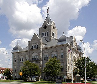
Bolivar is a city and county seat of Polk County, Missouri, United States.

<span class="mw-page-title-main">Fair Play, Missouri</span> City in Missouri, United States

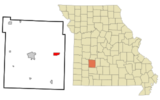
Fair Play is a city in western Polk County, Missouri, United States. The population was 475 at the 2010 census. It is part of the Springfield, Missouri Metropolitan Statistical Area.

<span class="mw-page-title-main">Flemington, Missouri</span> Village in Missouri, United States

Flemington is a village in Polk County, Missouri, United States. The population was 148 at the 2010 census. It is part of the Springfield, Missouri Metropolitan Statistical Area.

<span class="mw-page-title-main">Halfway, Missouri</span> Village in Missouri, United States

Halfway is a village in Polk County, Missouri, United States. According to the 2010 census, the population of Halfway is 173. It is part of the Springfield, Missouri Metropolitan Statistical Area.

<span class="mw-page-title-main">Humansville, Missouri</span> City in Missouri, United States

Humansville is a city in Polk County, Missouri, United States. As of the 2020 census, the city population was 965.

<span class="mw-page-title-main">Pleasant Hope, Missouri</span> City in Missouri, United States

Pleasant Hope is a city in Polk County, Missouri, United States. The population was 614 at the 2010 census. It is part of the Springfield, Missouri Metropolitan Statistical Area.

<span class="mw-page-title-main">Eaton, New York</span> Town in New York, United States

Eaton is a town in Madison County, New York, United States. The population was 4,284 at the 2020 census.

<span class="mw-page-title-main">Polk, Ohio</span> Village in Ohio, United States

Polk is a village in Ashland County, Ohio, United States. The population was 310 at the 2020 census.

<span class="mw-page-title-main">Morrisville, Greene County, Pennsylvania</span> Census-designated place in Pennsylvania, United States

Morrisville is a census-designated place (CDP) in Franklin Township, Greene County, Pennsylvania, United States. The population was 1,265 at the 2010 census.

<span class="mw-page-title-main">Polk Township, Jefferson County, Pennsylvania</span> Township in Pennsylvania, United States

Polk Township is a township in Jefferson County, Pennsylvania, United States. The population was 282 at the 2020 census. It was named for President James K. Polk.

<span class="mw-page-title-main">Eureka, Polk County, Wisconsin</span> Town in Wisconsin, United States

Eureka is a town in Polk County, Wisconsin, United States. The population was 1,338 at the 2000 census. The unincorporated community of Eureka Center is located in the town.

<span class="mw-page-title-main">Argyle, Missouri</span> Town in Missouri, United States

Argyle is a town in Osage and Maries counties in the U.S. state of Missouri. The population was 144 at the 2020 census.

Balsam Lake is a town in Polk County, Wisconsin, United States. The population was 1,384 at the 2000 census. The Village of Balsam Lake is located within the town. The unincorporated community of Lykens is also located in the town.

<span class="mw-page-title-main">Osceola, Polk County, Wisconsin</span> Town in Wisconsin, United States

Osceola is a town in Polk County, Wisconsin, United States. The population was 2,085 at the 2000 census. The village of Osceola is located mostly within the town. The unincorporated community of Nye is also located in the town.

References

  1. "ArcGIS REST Services Directory". United States Census Bureau. Retrieved August 28, 2022.
  2. 1 2 U.S. Geological Survey Geographic Names Information System: Morrisville, Missouri
  3. 1 2 "U.S. Census website". United States Census Bureau . Retrieved January 31, 2008.
  4. Eaton, David Wolfe (1917). How Missouri Counties, Towns and Streams Were Named. The State Historical Society of Missouri. pp.  343.
  5. "Post Offices". Jim Forte Postal History. Retrieved December 10, 2016.
  6. Missouri Atlas & Gazetteer, DeLorme, 1st ed., 1998, p.51 and 52 ISBN   0899332242
  7. "US Gazetteer files 2010". United States Census Bureau. Archived from the original on January 25, 2012. Retrieved July 8, 2012.
  8. "Census of Population and Housing". Census.gov. Retrieved June 4, 2015.
  9. "U.S. Census website". United States Census Bureau . Retrieved July 8, 2012.
  10. "Marion C. Early R-V School District". Great Schools. Retrieved March 18, 2018.
  11. "About us". Polk County Library. Archived from the original on March 18, 2018. Retrieved March 18, 2018.