Ridgeville is an unincorporated community in Mineral County, West Virginia, United States. It lies along U.S. Routes 50 and 220 in the Mill Creek Valley, west of Markwood.

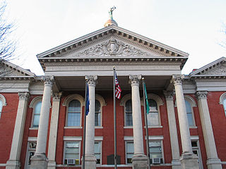
Buildings, sites, districts, and objects in Virginia listed on the National Register of Historic Places:
Files Crossroad is an unincorporated community in Berkeley County, West Virginia. The community is located east of Martinsburg on West Virginia Route 45 at its crossroads with County Route 45/4. The community was originally known as Smoketown, hence the name of its historic Smoketown Cemetery.
Nollville is an unincorporated community on Tuscarora Creek in Berkeley County, West Virginia. It lies west of Martinsburg on the Tuscarora Pike.

Elkhorn is an unincorporated community in McDowell County, West Virginia, United States. Elkhorn lies on U.S. Route 52 and takes its name from the creek that flows through the community.
French Creek is an unincorporated community in Upshur County, West Virginia, United States.

Cedar Creek and Belle Grove National Historical Park became the 388th unit of the United States National Park Service when it was authorized on December 19, 2002. The National Historical Park was created to protect several historically significant locations in the Shenandoah Valley of Northern Virginia, notably the site of the American Civil War Battle of Cedar Creek and the Belle Grove Plantation.

Miller's Tavern, Virginia is a small community located on the border of Essex County and King and Queen County, Virginia, in the United States.
Greenville is an unincorporated community in Monroe County, West Virginia, United States. Greenville is located on West Virginia Route 122 west of Union. The community was formerly called Centreville.
Henry Miller House may refer to:

This is a list of the National Register of Historic Places listings in Franklin County, Virginia.

This is a list of the National Register of Historic Places listings in Halifax County, Virginia.

Fine Creek Mills Historic District is a property on the National Register of Historic Places in Powhatan County, Virginia, United States.
Newport is an unincorporated community in Augusta County, Virginia, United States. Newport is located on Virginia State Route 252 7 miles (11 km) southeast of Craigsville.
Edom is an unincorporated community located in Rockingham County, in the U.S. state of Virginia. It is located along State Route 42 at the crossroads with State Route 721, north of Harrisonburg and southeast of Singers Glen. Linville Creek flows through the village.

Tuscarora Creek Historic District is a national historic district located near Martinsburg and Nollville, Berkeley County, West Virginia. It encompasses 31 contributing buildings and three contributing sites, related to the early settlement and economic development along the Tuscarora Creek. Notable buildings in the district include: Patterson's Mill (1765) and the miller's house, "Elm Dale," the Silber-Walters House, Huxley Hall, site of Patterson's New Mill and miller's house, Hibbard Mill, Tuscarora School, Providence Cemetery, the Mong House, Tuscarora Church (1802), James Noll Shop, Rumsey Mill site, and the poor house or "Mansion House" (1788).
The National Register Information System (NRIS) is a database of properties that have been listed on the United States National Register of Historic Places. The database includes more than 84,000 entries of historic sites that are currently listed on the National Register, that were previously listed and later removed, or that are pending listing. The database includes approximately 45 pieces of data for each listed property. Accuracy of the NRIS database may be imperfect. For example, a 2004 paper addressed accuracy of spatial location data for part of the NRIS content.

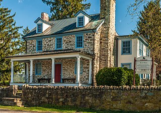
Hannah Miller House, also known as the William Joseph House, is a historic home located near Mossy Creek, Augusta County, Virginia. It was built about 1814, and is a two-story, banked stone "Continental bank" house style dwelling. It sits on a full, but not fully excavated, basement and has an exterior stone chimney. As of 1978, the interior of the house was absolutely plain and little-altered, with a single room on each floor.

Henry Miller House is a historic home located near Mossy Creek, Augusta County, Virginia. The original section was built about 1785, and expanded in the mid-19th century. It is a two-story, stone and brick dwelling with a combined gable and hipped roof. It consists of a square, four-bay, double-pile section with a three-bay, single-pile attached wing to form unbroken seven-bay facade. It features a full-width, one-story porch. Also on the property are a contributing two-story, one-cell rubble stone kitchen and two-story, three-bay, single-cell spring house.
Atoka is an unincorporated community in Fauquier County, Virginia, United States. Atoka is located along U.S. Route 50 4 miles (6.4 km) west of Middleburg.