Moston Brook

Last updated

Moston Brook
Moston Brook, Manchester.jpg
Moston Brook near Williams Road, Manchester
Greater Manchester UK relief location map.jpg
Red pog.svg
Location of the mouth within Greater Manchester
Location
CountryEngland
Region Greater Manchester
District Manchester/Oldham
Physical characteristics
Source 
  location Failsworth, Oldham, Greater Manchester, United Kingdom
Mouth  
  location
River Irk
  coordinates
53°29′47″N2°13′39″W / 53.49639°N 2.22750°W / 53.49639; -2.22750
Length3.7 mi (6.0 km)

Moston Brook is a stream in Greater Manchester in north-west England and a tributary of the River Irk. The brook is formed at the confluence of Bower Brook and Hole Bottom Brook. This occurs near the Rochdale Canal in Failsworth in the Metropolitan Borough of Oldham. It flows southwest, forming the border between Moston, Manchester and Failsworth before being culverted almost all of the remaining route to its meeting the River Irk. It has a total length of about 3.7 miles (6 kilometres).

Contents

The river was used industrially during the Cottonopolis period of Manchester's history, such as for the washing, bleaching and dyeing of yarns, although Moston was mostly noted for silk weaving. Clay and sand pits, which once fed brickworks, were later used for landfill sites. These landfills were later expanded by culverting the brook, though the last one closed in the 1990s. The brook's heavy industrial use and urban location led to it becoming badly polluted. In the early 2000s, the brook was identified as one of the most polluted bodies of water in Greater Manchester, if not the whole of the North West of England. However, this was the beginning of an ongoing concerted effort to enhance the water quality of the brook. This included work to divert and renovate combined sewer overflows, and the installation of drainage channels to divert surface water from nearby industrial sites and leachate from historic landfills. Work continues to improve the environment around the brook. Reprofiling and landscaping in the 1980s and environmental improvements in the 21st century mean that the brook is now seen as a community asset and an area of biodiversity. The remaining parts of the brook that avoided being culverted are used for recreation by the local community.

Course

A map showing most of the non-culverted parts of Moston Brook Moston Brook OpenStreetMap.png
A map showing most of the non-culverted parts of Moston Brook

The brook flows approximately 3.7 miles (6.0 km) from its source (the confluence of Bower Brook and Hole Bottom Brook) to its confluence with the River Irk. It forms part of the River Irwell drainage basin. [1]

The source of Moston Brook is now hidden. Its most upstream part is fully obscured in two culverts, the South Culvert and the North Culvert. [2] The South Culvert is what remains of one of the brook's upstream tributaries, Bower Brook, which flows from the Werneth area [3] and past a pumping station in South Chadderton. [2] Another tributary, Hole Bottom Brook, rises in north Hollinwood and runs to the Failsworth boundary near the Rochdale Canal, where a short section is still in daylight. [2] [3] [4] The North Culvert was connected in the 1990s in order to take run-off from a newly constructed part of the M60 motorway. [4] The confluence of Bower Brook and Hole Bottom Brook is considered the start of Moston Brook proper. [4]

The brook then flows southwest, forming the boundary between the City of Manchester and the Metropolitan Borough of Oldham, [5] both of which are metropolitan boroughs of Greater Manchester. It is partly culverted at Broadway Common due to landfilling activities. [4] The brook flows into Manchester at the southern boundary between Moston and Newton Heath, where it passes into another culvert which takes it underneath Moston Vale. [6] Here it is joined by the Dean Brook, which flows past the site of Moston Hall in Broadhurst Park and is also culverted south of Joyce Street. Up to the early nineteenth century, the section between Failsworth and the Dean Brook was known as Morris Brook. [7] The brook is briefly visible again in Collyhurst near Manchester Communication Academy, [2] before again entering culverts which take it most of the way to its confluence with the River Irk. [6]

The main part of the brook that is currently above ground is broken down into the following areas: [8]

History

There were once "white hills" beside the brook near Wrigley Head, here shown in 1970. Moston Brook and the White Hills, east of Belgrave Road, November 1970.jpg
There were once "white hills" beside the brook near Wrigley Head, here shown in 1970.

The area was largely rural but had been engaged in the washing, bleaching and dyeing of yarns since the 16th century, although Moston itself was mostly noted for silk weaving. [4] [12] By 1848, Moston Mill Print Works had already sprung up next to the brook to make use of the running water, joined later by Spring Valley Dye Works in Failsworth. A mill pond, a mill race and a weir were constructed to feed the former, of which only the weir remains. [4] Monsall Hospital was constructed on the banks of the brook in 1871. In 1878, North Road football stadium and cricket ground was built nearby for the use of Newton Heath LYR works team, the team that would later become Manchester United F.C. [11] [13]

There were "white hills" along the banks of the brook, formed from industrial waste. [4] The origin of the hills is unclear, though the hills are shown in photographs dated 1913. [14] Excavation of clay and sand pits alongside the brook fed brickworks on Hale Lane, Failsworth. [4] From around 1949, these pits were used as landfills, the last of which (Hardman Fold) was closed in the 1990s. [4] The brook was gradually culverted along much of its length, in some cases to make room for more landfill sites. [9] For example, the part of the brook that was near Monsall Hospital was culverted to make way for a landfill in the mid-1970s. [9] The hospital itself closed down in 1993 and was demolished soon after. [15] Moston Brook High School, which was built on the former site of the North Road sports pitches, was closed in August 2000. [16]

The remaining visible part of the brook between Failsworth and Moston was reprofiled and landscaped in the 1980s. Valley slopes were smoothed, paths and steps were incorporated, drainage channels were installed and stabilisation work was conducted. [4]

Environment

Pollution

The proliferation of factories and works in north Manchester, Failsworth and Oldham during and after the Industrial Revolution led to Moston Brook becoming badly polluted. Local children referred to it as the "Black Brook", though the brook changed colour depending on the dyes or pigments being discharged into the brook and its tributaries. [17] At the time, children were known to have drowned in the brook while playing there. [17] Other pollutants over the years included oil gas tar from Hollinwood Gas Works and waste from Failsworth tannery. [18] Both the Rochdale and Hollinwood Canals discharged overflows into the streams, so pollution from the canal water would also find its way into the system. [3]

The inflow to one of Moston Brook's culverts Moston Brook, Manchester - Williams Road culvert inflow.jpg
The inflow to one of Moston Brook's culverts

From 1990 to 2007, the brook consistently received the lowest possible grade from the Environment Agency, meaning it was very polluted and had a severely restricted ecosystem. [19] [20] Of all the bodies of water in the Water Framework Directive, it was considered one of the most challenging to improve. [1] It was thus one of the most polluted bodies of water in Greater Manchester, [21] possibly even in the whole North West of England. [1] As part of the Water Framework Directive, it was given the Ecological Quality of Moderate Potential and the possibility of achieving good status by 2027. [1] The brook was failing with regard to levels of ammonia, phosphate and dissolved oxygen. [1]

Improvements

These poor results led to the Environment Agency and United Utilities agreeing to work together to improve the brook's water quality. [19] This included screening of combined sewer overflows (CSOs). [20] An assessment in 2013 found that the likely causes of pollution in the brook included: intermittent discharge from sewers during storm overflows; leachate from old landfill sites; and continuous sewage discharges from domestic properties due to wrong connections. [1] [2] Other factors investigated were leakage from St Josephs's Cemetery and runoff from the M60 motorway. [1] [2] The study found that fish are absent from the brook. [1]

United Utilities has spent £2 million improving sewerage infrastructure near the brook and the Greater Manchester Waste Disposal Authority (GMWDA) has spent £400,000 on a methane-stripping plant for one of its former landfills. [21] The Environment Agency has funded sustainable drainage systems to prevent surface water entering the brook from a nearby industrial site and former landfill areas. [22] Both Oldham and Manchester Councils recognise the brook's potential as an area of biodiversity. [20] In 2010, Oldham Council hired a member of staff as project officer, in charge of improving the quality of the Moston Brook corridor. [21] Manchester Council has investigated fly tipping incidents. [21]

Song thrushes have been found around Moston Brook (illustrative) Song thrush near Faringdon Folly - geograph.org.uk - 682555.jpg
Song thrushes have been found around Moston Brook (illustrative)

There is a local friends group called Moston Brook Friends Group. [8] The group meets to plan access improvements, events, volunteering sessions, guided walks and nature activities.

Wildlife

A habitat survey of the Moston Brook corridor was conducted by The Greater Manchester Ecology Unit in 2007. [23] Important habitats identified include lowland broad leaved woodland, marshy grassland, reed bed and lowland heath/acid grassland, all of which are priority habitats for conservation listed in the national and Greater Manchester Biodiversity Action Plans. Important species identified included song thrush, house sparrow, starling, snipe and kestrel.

The Moston Brook corridor is bookended by two important sites designated for their nature conservation area. The first of the Rochdale Canal Special Area of Conservation (SAC) and Site of Special Scientific Interest (SSSI) which is a European Designated Site of international conservation importance. The second is the Moston Fairway Nature Reserve (former railway sidings at Moston), a Site of Biological Importance (SBI) which is a designated site of sub-regional nature conservation importance. [23]

Recreation

On the border between Moston and Failsworth, Moston Brook is a recreational resource for residents of both communities. [20] The project officer for the site is tasked with coordinating activities and encouraging the local communities to make use of the corridor. [21] For example, an annual Fun Day is held on Lower Failsworth Memorial Land, with activities such as falconry displays, bouncy castles, arts and crafts and model train rides. [8] [24] Lancashire Wildlife Trust has organised volunteering sessions around Moston Brook and the project officer has conducted bat spotting tours with the local community. [21]

Entrances to the brook have been built along its route by Oldham and Manchester Councils. [25] These allow access to paths and cycleways which can be used for walks, rides and educational activities. [21]

See also

Related Research Articles

<span class="mw-page-title-main">Failsworth</span> Town in Greater Manchester, England

Failsworth is a town in the Metropolitan Borough of Oldham in Greater Manchester, England, 3.7 miles (6.0 km) north-east of Manchester city centre and 2.9 miles (4.7 km) south-west of Oldham. The orbital M60 motorway skirts it to the east. The population at the 2011 census was 20,680. Historically in Lancashire, Failsworth until the 19th century was a farming township linked ecclesiastically with Manchester. Inhabitants supplemented their farming income with domestic hand-loom weaving. The humid climate and abundant labour and coal led to weaving of textiles as a Lancashire Mill Town with redbrick cotton mills. A current landmark is the Failsworth Pole. Daisy Nook is a country park on the southern edge.

<span class="mw-page-title-main">River Medlock</span> River in Greater Manchester, England

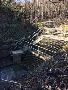
The River Medlock is a river in Greater Manchester, England, which rises near Oldham and flows south and west for 10 miles to join the River Irwell in Manchester city centre.

<span class="mw-page-title-main">Moston, Manchester</span> Human settlement in England

Moston is a suburb of Manchester, in North West England, approximately 3 miles (4.8 km) north-east of the city centre. Historically in Lancashire, Moston is a predominantly residential area, with a population of 14,518 at the 2011 census and an area of approximately 1,300 acres (5.3 km2).

<span class="mw-page-title-main">Hollinwood tram stop</span> Manchester Metrolink tram stop

Hollinwood tram stop is a tram stop and park & ride site on the Manchester Metrolink Oldham and Rochdale Line in Hollinwood, Greater Manchester, England. It was formerly a railway station before its conversion to a tram stop between 2009 and 2012.

<span class="mw-page-title-main">Failsworth tram stop</span> Manchester Metrolink tram stop

Failsworth tram stop is a Manchester Metrolink tram stop on the Oldham and Rochdale Line in Failsworth, Greater Manchester. It was formerly a railway station before its conversion to Metrolink in 2012.

<span class="mw-page-title-main">Freehold tram stop</span> Manchester Metrolink tram stop

Freehold is a tram stop on the Oldham and Rochdale Line (ORL) of Greater Manchester's light-rail Metrolink system. It opened to passengers on 13 June 2012 as part of Phase 3a of the system's expansion, and is located on Block Lane in Chadderton at its boundary with Oldham in the Metropolitan Borough of Oldham, England.

<span class="mw-page-title-main">Monsall tram stop</span> Manchester Metrolink tram stop

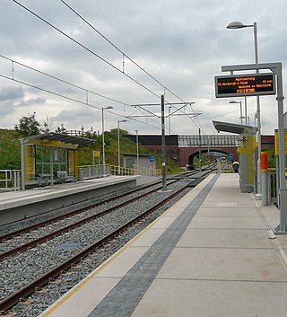
Monsall is a tram stop on the Oldham and Rochdale Line (ORL) of Greater Manchester's light-rail Metrolink system in the Monsall area of Manchester in North West England. It was built as part of Phase 3a of the system's expansion, on the route of the former Oldham Loop Line, and opened to passengers on 13 June 2012.

<span class="mw-page-title-main">New Moston</span> Human settlement in England

New Moston is a suburb of Manchester, England.

<span class="mw-page-title-main">Ace Mill, Hollinwood</span>

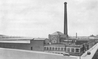
Ace Mill is a cotton spinning mill in Chadderton in the Metropolitan Borough of Oldham, Greater Manchester. It was built as Gorse No. 2 Mill, in 1914 and cotton was first spun in 1919 by the Ace Mill Ltd, who renamed the mill. It was taken over by the Lancashire Cotton Corporation in the 1930s and passed to Courtaulds in 1964. Production ended in 1967.

<span class="mw-page-title-main">Fox Mill</span>

Fox Mill was a cotton spinning mill in Hollinwood, Oldham, Greater Manchester, England. It was taken over by the Lancashire Cotton Corporation in the 1930s and passed to Courtaulds in 1964.

<span class="mw-page-title-main">Kent Mill, Chadderton</span>

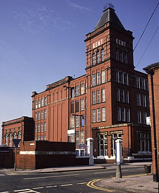
Kent Mill, Chadderton was a cotton spinning mill in Chadderton, Oldham, Greater Manchester. It was built in 1908 for the Kent Mill Co. It was taken over by the Lancashire Cotton Corporation in 1938 and passed to Courtaulds in 1964. Production finished in 1991 and it was demolished in 1994.

<span class="mw-page-title-main">Heron Mill, Hollinwood</span> Cotton spinning mill in Oldham, Greater Manchester, England

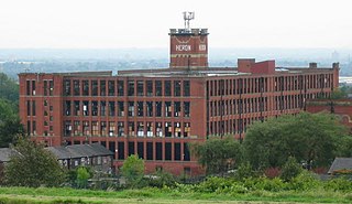
Heron Mill is a cotton spinning mill in Hollinwood, Oldham, Greater Manchester. It was designed by architect P. S. Stott and was constructed in 1905 by the Heron Mill Company Ltd next to Durban Mill. It was taken over by the Lancashire Cotton Corporation in the 1930s and passed to Courtaulds in 1964. Production ended in 1960, and it was used by Courtaulds for offices, warehousing, and some experimental fabric manufacture. Courtaulds occupation ended in 1994.

<span class="mw-page-title-main">Royd Mill, Oldham</span> Cotton mill in Greater Manchester, England

Royd Mill, Oldham was a cotton spinning mill in Hollinwood, Oldham, Greater Manchester, England. It was built in 1907, and extended in 1912 and 1924. It was taken over by the Lancashire Cotton Corporation in the 1930s and passed to Courtaulds in 1964. Production finished in 1981. The mill was demolished in 2015 to make way for a "DifRent" housing scheme.

<span class="mw-page-title-main">Laurel Mill, Middleton Junction</span> Former cotton mill in Manchester, England

Laurel Mill was a cotton spinning mill in the Mills Hill/Middleton Junction area of Chadderton, Oldham, Greater Manchester, England.

<span class="mw-page-title-main">Harp Mill, Castleton</span> Cotton mill in Greater Manchester, England

Harp Mill was a former cotton spinning mill in the Castleton, Rochdale, Greater Manchester, England. Queensway, Castleton was a hub of cotton mills including the three 't', Th'Arrow, Th'Harp, and Th'Ensor. The 1908 Castleton map includes: Marland Cotton Mill, Castleton Cotton Mill, Globe Works, Arrow Cotton Mill, Harp Cotton Mill, Globe Leather Works, Castleton Size Works and Castleton Iron Works. Th'Harp was taken over by the Lancashire Cotton Corporation in the 1930s and passed to Courtaulds in 1964. The site now houses industrial units.

<span class="mw-page-title-main">Mars Mill, Castleton</span> Cotton mill in Greater Manchester, England

Mars Mill was a former cotton spinning mill in Castleton, Rochdale, Greater Manchester, England. Castleton joined the Borough of Rochdale in 1899. Queensway, Castleton was a hub of cotton mills; Mars, Marland, and Castleton Mill were a group of three. It was taken over by the Lancashire Cotton Corporation in 1935 and passed to Courtaulds in 1964 and demolished in the 1990s; Marland survived until 2004.

<span class="mw-page-title-main">Newton Heath and Moston tram stop</span> Manchester Metrolink tram stop

Newton Heath and Moston is a Manchester Metrolink tram stop on the Oldham and Rochdale Line (ORL), in the Newton Heath area of Manchester, England.

Whitegate is an industrial and residential district of the town of Chadderton in the Metropolitan Borough of Oldham, Greater Manchester, England.

<span class="mw-page-title-main">Butler Green</span> Human settlement in England

Butler Green is a residential area in the town of Chadderton in the Metropolitan Borough of Oldham, Greater Manchester. The area is also commonly known as Washbrook.

<span class="mw-page-title-main">Oldham and Rochdale Line</span> Manchester Metrolink line

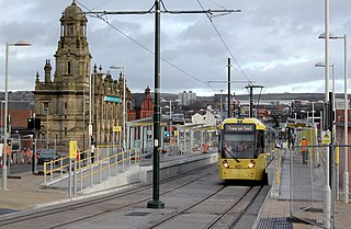
The Oldham and Rochdale Line (ORL) is a tram line of the Manchester Metrolink in Greater Manchester running from Manchester city centre to Rochdale town centre via Oldham, using most of the trackbed of the former Oldham Loop Line which closed in 2009. The line was re-opened in a modified form as a tramway between 2012 and 2014, as part of phase three of the system's expansion.

References

  1. 1 2 3 4 5 6 7 8 "Moston Brook – Summary Report for the Evidence and Measures Project" (PDF). Environment Agency. 20 March 2013. Archived from the original (PDF) on 20 February 2019. Retrieved 19 February 2018.
  2. 1 2 3 4 5 6 "Practical Solutions – Moston Brook" (PDF). Environment Agency. 25 April 2013. Archived from the original (PDF) on 1 November 2018. Retrieved 19 February 2018.
  3. 1 2 3 "Lancashire XCVII (includes: Lees; Oldham.)". Ordnance Survey . 1848.
  4. 1 2 3 4 5 6 7 8 9 10 "Moston Brook Feasibility Study" (PDF). Groundwork Oldham & Rochdale. March 2008. Archived from the original (PDF) on 20 February 2019. Retrieved 19 February 2018.
  5. "Election Maps". Ordnance Survey. Retrieved 20 February 2019.
  6. 1 2 "Moston Brook". Hidden Manchester Map. 13 August 2016. Archived from the original on 20 February 2019. Retrieved 19 February 2018.
  7. H. T. Crofton (1904). A history of Newton chapelry in the ancient parish of Manchester. James Stewart. p. 178.
  8. 1 2 3 "Moston Brook Green Corridor". Oldham Council. Archived from the original on 3 April 2019. Retrieved 20 February 2018.
  9. 1 2 3 "Historic landfill map". UK Government. Retrieved 15 July 2018.
  10. "Maps showing rights of way". RowMaps. Retrieved 27 February 2019.
  11. 1 2 "Moston Fairway". Lancashire Wildlife Trust. Archived from the original on 15 April 2021. Retrieved 20 February 2019.
  12. "Townships: Moston". British History Online. Archived from the original on 4 November 2021. Retrieved 27 February 2019.
  13. "Moston Vale". Newlands Project. Archived from the original on 19 April 2021. Retrieved 15 July 2018.
  14. "Images "m60385" and "m60386"". Manchester Image Collection. Retrieved 27 February 2019.
  15. "Monsall Hospital – Hospital Records Database". National Archives. Archived from the original on 1 April 2019. Retrieved 15 July 2018.
  16. "Moston Brook High School". UK Government. Archived from the original on 1 April 2019. Retrieved 20 February 2018.
  17. 1 2 "Kath Elsworth". Pride Media Association. Archived from the original on 3 July 2016. Retrieved 19 February 2018.
  18. G. Strath Leslie (1909). "Urban District of Failsworth – Report of the Medical Officer of Health for the year 1909". J. B. Fielding.
  19. 1 2 Ottewell, David (20 December 2007). "Polluted brooks that struggle to babble". Manchester Evening News. Archived from the original on 18 April 2021. Retrieved 19 February 2018.
  20. 1 2 3 4 "The water quality ratings of Manchester's rivers and measures to attract people down to the waterside". Manchester City Council. 11 December 2007. Archived from the original on 20 February 2019. Retrieved 19 February 2018.
  21. 1 2 3 4 5 6 7 "Oldham – cleaning up Moston Brook". Local Government Association. Retrieved 19 February 2018.
  22. "Groundwork – Moston Brook water quality and habitat enhancement scheme". Groundwork. Archived from the original on 1 April 2019. Retrieved 19 February 2018.
  23. 1 2 "Extended Phase 1 Habitat Survey of Moston Brook Corridor and Moston Fairway" (PDF). The Greater Manchester Ecology Unit. October 2007. Retrieved 27 February 2019.
  24. "Moston Brook Fun Day". Ann Bates. 10 August 2014. Archived from the original on 26 January 2022.
  25. "Moston Brook improvements". Oldham Council. Archived from the original on 20 February 2019. Retrieved 20 February 2018.

53°30′24″N2°10′48.5″W / 53.50667°N 2.180139°W / 53.50667; -2.180139