
A dune is a landform composed of wind- or water-driven sand. It typically takes the form of a mound, ridge, or hill. An area with dunes is called a dune system or a dune complex. A large dune complex is called a dune field, while broad, flat regions covered with wind-swept sand or dunes, with little or no vegetation, are called ergs or sand seas. Dunes occur in different shapes and sizes, but most kinds of dunes are longer on the stoss (upflow) side, where the sand is pushed up the dune, and have a shorter slip face in the lee side. The valley or trough between dunes is called a dune slack.

Lake Michigan is one of the five Great Lakes of North America. It is the second-largest of the Great Lakes by volume and the third-largest by surface area, after Lake Superior and Lake Huron. To the east, its basin is conjoined with that of Lake Huron through the 3+1⁄2-mile (5.6-kilometer) wide, 295-foot deep Straits of Mackinac, giving it the same surface elevation as its easterly counterpart; geologically, the two bodies are a single lake that is, by area, the largest freshwater lake in the world.
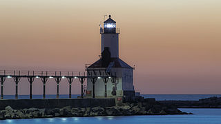
Michigan City is a city in LaPorte County, Indiana, United States. It had a population of 32,075 at the 2020 census. Located along Lake Michigan in the Michiana region, the city is about 45 miles (72 km) east of Chicago and is 40 miles (64 km) west of South Bend.

Beverly Shores is a town in Pine Township, Porter County, Indiana, United States, about 36 miles (58 km) east of downtown Chicago. The population was 613 at the 2010 census.

Indiana Dunes National Park is a United States national park located in northwestern Indiana managed by the National Park Service. It was authorized by Congress in 1966 as the Indiana Dunes National Lakeshore and was redesignated as the nation's 61st national park on February 15, 2019. The park runs for about 20 miles (32 km) along the southern shore of Lake Michigan and covers 15,349 acres (6,212 ha). Along the lakefront, the eastern area is roughly the lake shore south to U.S. 12 or U.S. 20 between Michigan City, Indiana, on the east and the Cleveland-Cliffs steel plant on the west. This area's conservation scheme is enhanced by the older Indiana Dunes State Park. To the west of the steel plant lies West Beach and a small extension south of the steel mill continues west along Salt Creek to Indiana 249. The western area is roughly the shoreline south to U.S. 12 between the Burns Ditch west to Broadway in downtown Gary, Indiana. In addition, there are several outlying areas, including Pinhook Bog, in LaPorte County to the east; the Heron Rookery in Porter County, the center of the park; and the Calumet Prairie State Nature Preserve and the Hobart Prairie Grove, both in Lake County, the western end of the park.
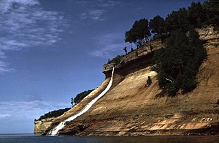
Pictured Rocks National Lakeshore is a U.S. National Lakeshore in the Upper Peninsula of Michigan, United States. It extends for 42 mi (68 km) along the shore of Lake Superior and covers 73,236 acres. The park has extensive views of the hilly shoreline between Munising and Grand Marais in Alger County, with picturesque rock formations, waterfalls, and sand dunes.

Indiana Dunes State Park is an Indiana State Park located in Porter County, Indiana, United States, 47 miles (75.6 km) east of Chicago. The park is bounded by Lake Michigan to the northwest and is surrounded by as well as within the authorized boundaries of Indiana Dunes National Park, a unit of the National Park Service; the NPS owns the water from the ordinary high water mark to 300 feet (91 m) offshore. The 1,530-acre (619.2 ha) Dunes Nature Preserve makes up the bulk of eastern part of the park, and includes most of the park's hiking trails and dune landscape. This was one of the first places Richard Lieber considered when establishing the Indiana State Park system. Like all Indiana state parks, there is a fee for entrance. Indiana Dunes State Park was established in 1925 and designated a National Natural Landmark in 1974.

Guadalupe-Nipomo Dunes is the largest remaining dune system south of San Francisco and the second largest in the U.S. state of California. It encompasses an 18-mile (29 km) stretch of coastline on the Central Coast of California and extends from southern San Luis Obispo County to northern Santa Barbara County.
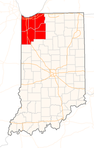
Northwest Indiana, nicknamed The Region after the Calumet Region, is an unofficial region of northern Indiana, United States that is located at the northwestern corner of the state. Though there is no official definition of the region, it is based on the Gary, Indiana Metropolitan Division, which comprises Jasper, Lake, Porter and Newton counties in Indiana, and the Michigan City-La Porte, IN Metropolitan Statistic Area, which comprises LaPorte, with unofficial definitions also including Starke and Pulaski counties. This region neighbors Lake Michigan and parts of it are in the Chicago metropolitan area. According to the 2020 Census, the largest definition of Northwest Indiana has a population of 866,965 and is the state's second largest urban area after the Indianapolis Metropolitan Area. It is also the home of the Indiana Dunes, parts of which have been preserved through conservation efforts. The town of Ogden Dunes houses the Hour Glass, a museum showcasing the ecological and conservation efforts of O. D. Frank.

Whitefish Dunes State Park is a 867-acre (351 ha) state park of Wisconsin on the eastern shore of the Door Peninsula. This day-use park preserves the most substantial sand dunes on the western shore of Lake Michigan. The remains of eight successive prehistoric Native American villages are on the National Register of Historic Places as Whitefish Dunes-Bay View Site. Cave Point County Park is an enclave inside the state park, allowing visitors free foot access to the state park by the shoreline trail connecting the parks.

The Calumet Trail is an east-west bicycle and multiuse recreational trail in the Calumet region of northwestern Indiana, United States. It runs roughly parallel to U.S. Route 12 and the right-of-way of the South Shore line, along the NIPSCO easement.

Jockey's Ridge State Park is a North Carolina state park in Dare County, North Carolina in the United States. Located in Nags Head, North Carolina, it covers a 427-acre (1.73 km2) area, and includes the tallest active sand dune system in the eastern United States. It is the most visited park within the NC park system. The park is a day-use only park and has no campgrounds. Jockey's Ridge contains three unique ecosystems: the Roanoke Sound, the dune system, and the maritime forest. Often when it rains, water collects near the bottom of the dunes creating temporary ponds known as vernal pools. Few fauna can be seen around the dunes, although some types of flora, such as tall grass, may be seen near the bottom of the dunes.
Leila (Lee) Botts was an American environmentalist known primarily for her work related to conservation and restoration of the Great Lakes. She founded two non-profit organizations, directed a subagency of the U.S. Department of the Interior in the administration of President Jimmy Carter, authored or co-authored a number of books and reports on environmental issues, served in the administration of the late Chicago Mayor Harold Washington, and co-produced a documentary film called Shifting Sands: On the Path to Sustainability, on the history of the Indiana Dunes region.

Miller Beach is a neighborhood of Gary, Indiana on the southernmost shore of Lake Michigan. First settled in 1851, Miller Beach was originally an independent town. However, the "Town of Miller" was eventually annexed by the then flourishing city of Gary in 1918. Located in the northeastern corner of Lake County, Indiana, the former town is now known as "The Miller Beach Community." Miller Beach borders Lake Michigan to the north, Porter County to the east, and is largely surrounded by protected lands, including Indiana Dunes National Park. Miller Beach is also the closest beach/resort community to Chicago, and has been a popular vacation spot since the early 20th century. As of the 2000 US census, it had a population of 9,900.

A devil's stovepipe or decomposition chimney is a hole formed when a tree, that has been buried by an encroaching sand dune, decomposes. Under certain conditions the bark will remain intact even after the core of the tree has rotted away. This cylinder of bark keeps the surrounding sand from collapsing in and thus creates a void, an unexpected occurrence in such an unstable medium.

Kohler-Andrae State Park comprises two adjacent Wisconsin state parks located in the Town of Wilson, a few miles south of the city of Sheboygan. They are managed as one unit. Terry Andrae State Park, established in 1927, and John Michael Kohler State Park, established in 1966, total 988 acres (4.00 km2). The parks contain over two miles (3 km) of beaches and sand dunes along the shore of Lake Michigan, with woods and wetlands away from the water. The Black River flows through the parks.

The Indiana Dunes comprise ten different habitats. Each provides for a unique combination of plants and animals. The range of the Indiana Dunes varies depending your source. The Indiana Lake Michigan Coastal Program uses the river drainage systems along the shoreline. This expands the area from the areas of lakeshore southward to the edges of the Valparaiso Moraine. This entire region has been dune landscapes since over 114,000 years before present (YBP). Traditionally, the Indiana Dunes area thought of as a narrow area along the shores of Lake Michigan, including the areas of Marquette Park in Gary, Indiana (1920), Indiana Dunes State Park (1926) and Indiana Dunes National Park,. The identified ten habitats can be found in these parks, where they have been preserved, but are also visible throughout the three counties of Northwest Indiana.

Mount Baldhead, also known as Mt. Baldy and Radar Hill, is a tall dune about seventy miles north of the Indiana border on the west shore of Michigan in Allegan County.

The Hoosier Slide was a large sand dune on the shore of Lake Michigan near Michigan City, Indiana. The 200-foot (61 m) dune was a popular tourist destination in the late 19th century, attracting visitors for the view from the top and to slide down the dune's face. At about the same time as it became a tourist attraction, it was found to be a good source of iron-rich sand that would make a light blue-tinted glass. The sand mining activity led to the dune's disappearance by 1920.


