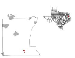
Mount Enterprise, Texas

Last updated
Mount Enterprise, Texas
US Post Office Mount Enterprise Texas.jpg
US Post Office in Mount Enterprise, Texas, USA
TXMap-doton-MountEnterprise.PNG
Location of Mount Enterprise, Texas
Rusk County MountEnterprise.svg
Coordinates: 31°54′57″N94°40′54″W / 31.91583°N 94.68167°W / 31.91583; -94.68167
Country Flag of the United States.svg  United States
State Flag of Texas.svg  Texas
County Rusk
Area
[1]
  Total1.49 sq mi (3.85 km2)
  Land1.49 sq mi (3.85 km2)
  Water0.00 sq mi (0.00 km2)
Elevation
479 ft (146 m)
Population
 (2010)
  Total447
  Estimate 
(2019) [2]
436
  Density293.60/sq mi (113.39/km2)
Time zone UTC-6 (Central (CST))
  Summer (DST) UTC-5 (CDT)
ZIP code
75681
Area code 903
FIPS code 48-49728 [3]
GNIS feature ID1363243 [4]

Mount Enterprise is a city in Rusk County, Texas, United States. The population was 447 at the 2010 census.

Contents

History

The city of Mount Enterprise, located south of Henderson in rural Rusk County, was named for a small elevation near the town and for the business enterprise of the Vinzent brothers, who settled it in 1832.

The town owes its existence to the presence of promising iron ore in the area. Charles Vinzent considered the "old mountain" nearby to be an "iron mountain," and he was not far off the mark; the brown, crumbly ore of the Weches formation that outcrops in the area has a better than 50 percent iron content. However, Vinzent's real enterprise came in the form of manufacturing and retailing. His factory made wagons, buggies, furniture, plows, caskets, and a patented churn. He launched a chain of stores to sell these products, and more, operating out of Mount Enterprise. At one time Vinzent had as many as four stores.

Lumbering was also an early industry of Mount Enterprise; the furniture factory it supported is dated as early as 1850. There were also numerous plantations in the area before the Civil War. In 1846 the Mulberry Grove post office was established with Henry Henson as postmaster. Three years later the name was changed to Mount Enterprise.

Mount Enterprise Male and Female College was begun in 1851, and it lasted until 1855. In 1853 Mount Enterprise Male and Female Academy was established. In 1880 the town had three sawmills, a hotel, two cotton gins, a school, three churches, and a population of 150.

In 1894 the Caro Northern Railway was chartered to operate as a logging road between Mount Enterprise and Caro, in Nacogdoches County, a distance of little over 16 miles. The railroad, which connected Mount Enterprise with the Texas and New Orleans Railroad, came to within a mile of Mount Enterprise, and the town then moved to the railroad. It became the new Mount Enterprise, and the old location was called the old Mount Enterprise.

The railroad was abandoned in 1934, but by 1939 the town had incorporated and still had a number of businesses, a bank, a post office, a newspaper, and a population of 920. After 1940 the population gradually declined to 485 in 1982, when the town had a bank, a post office, and fifteen businesses. In 1990 the population was 501. The population grew to 525 in 2000, but has since dropped to 447 according to the 2010 census.

Geography

Mount Enterprise is located at 31°54′57″N94°40′54″W / 31.91583°N 94.68167°W / 31.91583; -94.68167 (31.915852, –94.681673). [5]

According to the United States Census Bureau, the city has a total area of 1.5 square miles (3.8 km2), all of it land.

Demographics

Historical population
CensusPop.Note
1970 425
1980 48514.1%
1990 5013.3%
2000 5254.8%
2010 447−14.9%
2019 (est.)436 [2] −2.5%
U.S. Decennial Census [6]

As of the census [3] of 2000, there were 525 people, 206 households, and 155 families residing in the city. The population density was 355.9 inhabitants per square mile (137.4/km2). There were 241 housing units at an average density of 163.4 per square mile (63.1/km2). The racial makeup of the city was 91.05% White, 8.19% African American, and 0.76% from two or more races. Hispanic or Latino of any race were 1.71% of the population.

There were 206 households, out of which 30.1% had children under the age of 18 living with them, 64.6% were married couples living together, 7.8% had a female householder with no husband present, and 24.3% were non-families. 21.4% of all households were made up of individuals, and 15.5% had someone living alone who was 65 years of age or older. The average household size was 2.55 and the average family size was 2.97.

In the city, the population was spread out, with 25.7% under the age of 18, 7.6% from 18 to 24, 25.7% from 25 to 44, 22.5% from 45 to 64, and 18.5% who were 65 years of age or older. The median age was 39 years. For every 100 females, there were 95.9 males. For every 100 females age 18 and over, there were 88.4 males.

The median income for a household in the city was $25,577, and the median income for a family was $31,719. Males had a median income of $27,083 versus $20,125 for females. The per capita income for the city was $13,165. About 18.1% of families and 22.0% of the population were below the poverty line, including 33.9% of those under age 18 and 9.7% of those age 65 or over.

Education

The City of Mount Enterprise is served by the Mount Enterprise Independent School District.

Related Research Articles

<span class="mw-page-title-main">Rusk County, Texas</span> County in Texas, United States

Rusk County is a county located in Texas. As of the 2020 census, its population was 52,214. Its county seat is Henderson. The county is named for Thomas Jefferson Rusk, a secretary of war of the Republic of Texas.

<span class="mw-page-title-main">Saline County, Arkansas</span> County in Arkansas, United States

Saline County is located in the U.S. state of Arkansas. As of the 2020 census, the population was 123,416. Its county seat and largest city is Benton. Saline County was formed on November 2, 1835, and named for the salt water (brine) springs in the area, despite a differing pronunciation from saline. Until November 2014, it was an alcohol prohibition or dry county.

<span class="mw-page-title-main">Odenville, Alabama</span> Town in Alabama, United States

Odenville is a city in St. Clair County, Alabama, United States. It incorporated in 1914. At the 2010 census the population was 3,585, up from 1,131 in 2000. It annexed the former town of Branchville in 2007. Odenville annexed a portion of Springville in 2015 due to Springville not running water to some of its residences.

<span class="mw-page-title-main">Trenton, Illinois</span> City in Illinois, United States

Trenton is a city in Clinton County, Illinois, United States. The population was 2,690 at the 2020 census.
<span class="mw-page-title-main">Tonica, Illinois</span> Village in LaSalle County, Illinois

Tonica is a village in LaSalle County, Illinois, United States. The population was 749 at the 2020 census, down from 768 at the 2010 census. It is part of the Ottawa Micropolitan Statistical Area.

<span class="mw-page-title-main">Zanesville, Indiana</span> Town in Indiana, United States

Zanesville is a town in Allen and Wells counties in the U.S. state of Indiana, southwest of Fort Wayne. The population was 600 at the 2010 census.

<span class="mw-page-title-main">Mount Etna, Indiana</span> Town in Indiana, United States

Mount Etna is a town in Huntington County, Indiana, United States. The population was 94 at the 2010 census. It lies at the intersection of four townships: Jefferson, Lancaster, Polk and Wayne.

<span class="mw-page-title-main">Chatsworth, Iowa</span> City in Iowa, United States

Chatsworth is a city in Sioux County, Iowa, United States. The population was 75 at the 2020 census.

<span class="mw-page-title-main">Slater, Iowa</span> City in Iowa, United States

Slater is a city in Story County, Iowa, United States. The population was 1,543 at the time of the 2020 census.

<span class="mw-page-title-main">Fort Shawnee, Ohio</span> CDP in Ohio, United States

Fort Shawnee is census-designated place (CDP) in Allen County, Ohio, United States. The population was 6,263 at the 2020 census. It is included in the Lima, Ohio Metropolitan Statistical Area. Fort Shawnee is adjacent to the city of Lima and the village of Cridersville in Auglaize County. In 2012, village residents voted to disincorporate the village. Fort Shawnee is located at 40°40′54″N84°8′21″W. According to the United States Census Bureau, the village had a total area of 7.25 square miles (18.78 km2), of which 7.21 square miles (18.67 km2) is land and 0.04 square miles (0.10 km2) is water.

<span class="mw-page-title-main">Jonesville, South Carolina</span> City in South Carolina, United States

Jonesville is a town in Union County, South Carolina, United States. The population was 911 at the 2010 United States Census.
<span class="mw-page-title-main">Cuney, Texas</span> Town in Texas, United States

Cuney is a town located in northwest Cherokee County, Texas, United States. With a population of 116 at the 2020 U.S. census, Cuney was the only "wet" town in Cherokee County from the mid-1980s until 2009, when voters in Rusk came out in favor of beer/wine sales. After that result, voters in Jacksonville and Frankston have since voted in favor of beer/wine sales, and Rusk voters returned to the polls to vote in favor of liquor sales.

<span class="mw-page-title-main">Rusk, Texas</span> City in Texas, United States

Rusk is a city and the county seat of Cherokee County in the U.S. state of Texas. At the 2020 United States census, it had a population of 5,285.

<span class="mw-page-title-main">Cushing, Texas</span> City in Texas, United States

Cushing is a city in Nacogdoches County, Texas, United States. The population was 612 at the 2010 census.

<span class="mw-page-title-main">New London, Texas</span> City in Texas, United States

New London is a city in Rusk County, Texas, United States. The population was 958 at the 2020 census.
<span class="mw-page-title-main">Dewey, Rusk County, Wisconsin</span> Town in Wisconsin, United States

Dewey is a town in Rusk County, Wisconsin, United States. As of the 2000 census, the town had a total population of 523.

<span class="mw-page-title-main">Ladysmith, Wisconsin</span> City in Wisconsin, United States

Ladysmith is a city and the county seat of Rusk County, Wisconsin, United States. The population was 3,414 at the 2010 census.

<span class="mw-page-title-main">Rusk, Rusk County, Wisconsin</span> Town in Wisconsin, United States

Rusk is a town in Rusk County, Wisconsin, United States. The population was 475 at the 2000 census. The unincorporated community of Bear Lake is located in the town.

<span class="mw-page-title-main">Reklaw, Texas</span> City in Texas, United States

Reklaw is a city in Cherokee and Rusk counties in the U.S. state of Texas. The population was 379 at the 2010 census.
<span class="mw-page-title-main">Overton, Texas</span> City in Texas, United States

Overton is a city in Rusk and Smith counties in the U.S. state of Texas. Overton lies in two counties as well as two metropolitan areas. The Rusk County portion of the city is part of the Longview Metropolitan Statistical Area, while the Smith County portion is part of the Tyler Metropolitan Statistical Area.

References

  1. "2019 U.S. Gazetteer Files". United States Census Bureau. Retrieved August 7, 2020.
  2. 1 2 "Population and Housing Unit Estimates". United States Census Bureau. May 24, 2020. Retrieved May 27, 2020.
  3. 1 2 "U.S. Census website". United States Census Bureau . Retrieved 2008-01-31.
  4. "US Board on Geographic Names". United States Geological Survey. 2007-10-25. Retrieved 2008-01-31.
  5. "US Gazetteer files: 2010, 2000, and 1990". United States Census Bureau. 2011-02-12. Retrieved 2011-04-23.
  6. "Census of Population and Housing". Census.gov. Retrieved June 4, 2015.