Shelby County is a county located in the far eastern portion of the U.S. state of Texas. As of the 2020 census, its population was 24,022. Its county seat is Center. The county was established in 1835 as a municipality of Mexico and organized as a county in 1837. It is named for Isaac Shelby, a soldier in the American Revolution who became the first governor of Kentucky.

Rusk County is a county located in Texas. As of the 2020 census, its population was 52,214. Its county seat is Henderson. The county is named for Thomas Jefferson Rusk, a secretary of war of the Republic of Texas.

Panola County is a county located in the U.S. state of Texas. As of the 2020 census, its population was 22,491. The county seat is Carthage. Located in East Texas and originally developed for cotton plantations, the county's name is derived from a Choctaw word for cotton.

Harrison County is a county on the eastern border of the U.S. state of Texas. As of the 2020 United States census, its population was 68,839. The county seat is Marshall. The county was created in 1839 and organized in 1842. It is named for Jonas Harrison, a lawyer and Texas revolutionary.

Ellis County is a county located in the U.S. state of Texas. As of 2020, its population was estimated to be 192,455. The county seat is Waxahachie. The county was founded in 1849 and organized the next year. It is named for Richard Ellis, president of the convention that produced the Texas Declaration of Independence. Ellis County is included in the Dallas–Fort Worth–Arlington metropolitan statistical area.

Cherokee County is a county located in the U.S. state of Texas. As of the 2020 census, its population was 50,412. The county seat is Rusk, which lies 130 miles southeast of Dallas and 160 miles north of Houston. The county was named for the Cherokee, who lived in the area before being expelled in 1839. Cherokee County comprises the Jacksonville micropolitan statistical area, which is also included in the Tyler–Jacksonville combined statistical area.

Rusk is a city in and the county seat of Cherokee County, Texas, United States. At the 2020 United States census, it had a population of 5,285.

Taylor Lake Village is a city in Harris County, Texas, United States. The population was 3,704 at the 2020 U.S. census.

Webster is a city in the U.S. state of Texas located in Harris County, within the Houston–The Woodlands–Sugar Land metropolitan area. Its population was 12,499 at the 2020 U.S. census.

Scottsville is a city in Harrison County, Texas, United States. The population was 376 at the 2010 census, up from 263 at the 2000 census. Scottsville's population in 2020 decreased to 334.

Jacksboro is a city in Jack County, Texas, in the United States. Its population was 4,184 at the 2020 census. U.S. Highways 281 and 380, and Texas State Highways 114 and 199 intersect at Jacksboro, which is the county seat of Jack County.
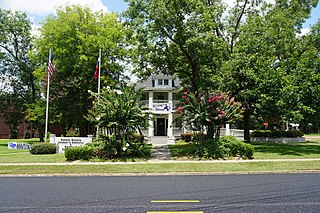
Carthage is a city in and the county seat of Panola County, Texas, United States. The city is situated in deep East Texas, 20 miles west of the Louisiana state line. Its population was 6,569 at the 2020 census.

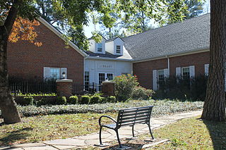
Henderson is a city and the county seat of Rusk County, Texas, in Northeast Texas, United States. Its population was 13,271 at the 2020 census. Henderson is named for James Pinckney Henderson, the first governor of Texas.

New London is a city in Rusk County, Texas, United States. The population was 958 at the 2020 census.
Mathis is a city in San Patricio County, Texas, United States. The population was 4,333 at the 2020 census.

Seabrook is a city in Harris County, Texas, United States, with some water surface area located within Chambers County. The population was 13,618 at the 2020 U.S. census. Several fish markets line the city's waterfront, while antique shops and bed and breakfast establishments are found in the city's downtown area.

Rowlett is a city in Dallas and Rockwall Counties in Texas, United States, and an eastern suburb of Dallas. It is a growing, upscale community with nearly $1.5 billion in development in the Dallas–Fort Worth metroplex, located on Lake Ray Hubbard.

Easton is a city in Gregg and Rusk counties in the U.S. state of Texas. The population was 510 at the 2010 census, and 499 at the 2020 census.
Overton is a city in Rusk and Smith counties in the U.S. state of Texas. Overton lies in two counties as well as two metropolitan areas. The Rusk County portion of the city is part of the Longview Metropolitan Statistical Area, while the Smith County portion is part of the Tyler Metropolitan Statistical Area.
Lake Cherokee is an unincorporated community and census-designated place (CDP) in Gregg and Rusk counties, Texas, United States. Its population was 2,980 as of the 2020 census. Lake Cherokee is located 12 miles southeast of Gregg and northeastern Rusk counties on Cherokee Bayou. The lake is owned by the Cherokee Water Company to supply water for municipal, industrial, and recreational purposes. It has a capacity of 68,700 acre-feet. The lake impounds Cherokee Bayou. The top of the dam is at the elevation of 295 feet above the average sea level, but it has a max design of 291 feet above the average sea level.