Mount Harwood

Last updated
Mount Harwood
Harwood southeast snow.JPG
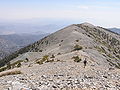
Mount Harwood (center) and Devil's Backbone (right) from the southeast, February 2008.
Highest point
Elevation 9,556 ft (2,913 m)  NAVD 88 [1]
Prominence 152 ft (46 m) [1]
Parent peak Mount San Antonio [2]
Listing Hundred Peaks Section [3]
Coordinates 34°17′11″N117°37′59″W / 34.2863929°N 117.6331103°W / 34.2863929; -117.6331103 [4]
Geography
Location San Bernardino County, California, U.S.
Parent range San Gabriel Mountains
Topo map USGS Mount San Antonio
Climbing
Easiest route Hike, class 1 [3]

Mount Harwood is the first summit east of Mount San Antonio. The United States Geological Survey recognized the name to honor California educator and conservationist Aurelia Squire Harwood in 1965. [4] Prior to this, the peak now known as Thunder Mountain was also referred to as Mount Harwood. [5] Mount Harwood is located on the East side of the San Gabriel Mountains in the Angeles National Forest near the San Bernardino-Los Angeles county border. In this area of the San Gabriel Mountains the peaks are the highest. Because of the elevation Mount Harwood turns out to be ranked the 4th highest peak in the San Gabriel mountains after Dawson Peak, Mount San Antonio or "Old Baldy" being the highest at 10,064 feet (3,068 m). The only way for hikers or tourists to access Mount Harwood is to take Mt. Baldy Road off I-210. A National Forest Adventure pass/ National Park access pass must be displayed on a vehicle to access Mount Harwood.

Related Research Articles

<span class="mw-page-title-main">San Gabriel Mountains</span> Mountain range of the Transverse Ranges in California, United States

The San Gabriel Mountains comprise a mountain range located in northern Los Angeles County and western San Bernardino County, California, United States. The mountain range is part of the Transverse Ranges and lies between the Los Angeles Basin and the Mojave Desert, with Interstate 5 to the west and Interstate 15 to the east. The range lies in, and is surrounded by, the Angeles and San Bernardino National Forests, with the San Andreas Fault as its northern border.

<span class="mw-page-title-main">Angeles National Forest</span> National forest in California, United States

The Angeles National Forest (ANF) of the U.S. Forest Service is located in the San Gabriel Mountains and Sierra Pelona Mountains, primarily within Los Angeles County in southern California. The ANF manages a majority of the San Gabriel Mountains National Monument.

<span class="mw-page-title-main">Bridger Range</span> Mountain range in the U.S. state of Montana

The Bridger Range, also known as the Bridger Mountains, is a subrange of the Rocky Mountains in southwestern Montana in the United States. The range runs mostly in a north–south direction between Bozeman and Maudlow. It is separated from the Gallatin Range to the south by Bozeman Pass; from the Horseshoe Hills to the west by Dry Creek; from the Crazy Mountains to the east by the Shields River valley; and from the Big Belt Mountains to the north by Sixteen Mile Creek. The highest point in the Bridger Range is Sacagawea Peak, which is visible to the northeast from Bozeman.

<span class="mw-page-title-main">Mount San Antonio</span> Highest peak of the San Gabriel Mountains in California, United States

Mount San Antonio, commonly referred to as Mount Baldy or Old Baldy, is a 10,064 ft (3,068 m) summit in the San Gabriel Mountains on the border of Los Angeles and San Bernardino counties of California. Lying within the San Gabriel Mountains National Monument and Angeles National Forest, it is the high point of the range, the County of Los Angeles, and the Los Angeles metropolitan area.

<span class="mw-page-title-main">Cucamonga Peak</span> Mountain in California, United States

Cucamonga Peak is one of the highest peaks of the San Gabriel Mountains in San Bernardino County, California, with a summit elevation of 8,862 feet (2,701 m). It is within the Cucamonga Wilderness of the San Bernardino National Forest.

<span class="mw-page-title-main">Mount Williamson</span> Mountain in California, United States

Mount Williamson, at an elevation of 14,379 feet (4,383 m), is the second-highest mountain in both the Sierra Nevada range and the state of California, and the sixth-highest peak in the contiguous United States.

<span class="mw-page-title-main">Mount Baden-Powell</span> Mountain in California, United States

Mount Baden-Powell is a peak in the San Gabriel Mountains of California named for the founder of the World Scouting Movement, Robert Baden-Powell, 1st Baron Baden-Powell. It was officially recognized by the USGS at a dedication ceremony in 1931. It was originally known as East Twin or North Baldy.

South Mount Hawkins is located in the San Gabriel Mountains, and contained within the Angeles National Forest. The mountain was named after Nellie Hawkins, a popular waitress of the Squirrel Inn located on the North Fork of the San Gabriel River. Although the Squirrel Inn is long gone, Nellie has her name on Mount Hawkins and South Mount Hawkins. There are two ridge bumps between the two named summits and they are unofficially known as "Middle Hawkins" and "Sadie Hawkins". According to the California State Library, "Cold Brook Camp, located within the Angeles National Forest, [was] very popular with campers. Started out as hunter's camp owned by R.W. Dawson. In 1901, land leased to Doc Beatty who opened hostelry called Squirrel Inn. In 1907, Dawson took over the Inn renaming it Cold Brook Camp. Eventually built hotel, cabins and tents. Was popular in early 1900s and into the 1920s."

<span class="mw-page-title-main">Iron Mountain (Los Angeles County)</span> Mountain in Los Angeles County, California

Iron Mountain is a mountain in the San Gabriel Mountains of Los Angeles County, California. It is within the San Gabriel Mountains National Monument, in the section managed by the Angeles National Forest.

<span class="mw-page-title-main">Mount Burnham</span>

Mount Burnham is one of the highest peaks in the San Gabriel Mountains. It is in the Sheep Mountain Wilderness. It is named for Frederick Russell Burnham the famous American military scout who taught Scoutcraft to Robert Baden-Powell and became one of the inspirations for the founding of the Boy Scouts. Mount Burnham was officially recognized by the USGS at a dedication ceremony in 1951. It was original known as "North Baldy Mountain". The peak is within Los Angeles County, about 16 miles (26 km) north of Glendora, and 66 miles (106 km) from Los Angeles. In 1956, Mount Burnham was added to the list of Signature Summits by the Hundred Peaks Section of the Sierra Club.

<span class="mw-page-title-main">South Baldy (New Mexico)</span>

South Baldy is the highest point of the Magdalena Mountains in central New Mexico, in the United States. It is in the Magdalena Ranger District of the Cibola National Forest, about 9 mi (15 km) south of Magdalena and 18 mi (30 km) west-southwest of Socorro. It lies just north of the Langmuir Laboratory for Atmospheric Research of the New Mexico Institute of Mining and Technology, and site of the Magdalena Ridge Observatory Interferometer.

Whitewater Baldy is the highest point of the Mogollon Mountains and the 3rd highest mountain in Southern New Mexico, after Sierra Blanca Peak and Lincoln County's Lookout Mountain. It is located in Catron County in the Gila Wilderness, part of the Gila National Forest. It lies about 15 miles (24 km) east of the town of Glenwood.

<span class="mw-page-title-main">Mount Baldy (Arizona)</span> Mountain in Apache County, Arizona, United States

Mount Baldy is an extinct stratovolcano in eastern Arizona in the United States. With a summit elevation of 11,409 feet (3,477 m), the peak of Mount Baldy rises above the tree line and is left largely bare of vegetation, lending the mountain its current name. The Mount Baldy Wilderness occupies the eastern slope of the mountain and is managed by the Apache-Sitgreaves National Forest.

Hot Springs Mountain is a peak located in the Peninsular Ranges in California. The mountain rises to an elevation of 6,533 feet (1,991 m) and is the highest point in San Diego County. Some snow falls on the mountain peak during winter. It is located in a remote region of the county, 4 miles from the community of Warner Springs, 12 miles from Borrego Springs, and 50 miles from San Diego. The mountain and its immediate surroundings belong to the Los Coyotes Band of Cahuilla and Cupeno Indians. The summit and fire tower can be hiked via the Sukat Road route from the campground. Hikers and campers must pay an entry fee to access the area.

<span class="mw-page-title-main">Ontario Peak</span> Mountain in California, United States

Ontario Peak is a 8,696 ft (2,651 m) high peak in the San Gabriel Mountains of California. Like its neighbor Cucamonga Peak, it is in the San Bernardino National Forest, and in the Cucamonga Wilderness. The peak is named for the nearby city of Ontario, about 12 mi (19 km) due south, and first appeared in the United States General Land Office Forest Atlas in 1908.

San Antonio Creek is a major stream in Los Angeles County and San Bernardino County, California, draining southwards from Mount San Antonio in the San Gabriel Mountains into Chino Creek, a tributary of the Santa Ana River. Upon leaving San Antonio Canyon and entering the broad alluvial plain of the Pomona Valley, it is known as the San Antonio Wash or the San Antonio Creek Channel, the former referring to the creek's seasonal dry nature below the mouth of San Antonio Canyon.

<span class="mw-page-title-main">Mount Phillips (New Mexico)</span>

Mount Phillips, formerly called Clear Creek Mountain was renamed in 1960 in honor of the then living Waite Phillips, who donated the area to the Boy Scouts of America. It is located in Colfax County about 11 miles (18 km) south of Baldy Mountain in the Cimarron Range, a subrange of the Sangre de Cristo Mountains of New Mexico.

<span class="mw-page-title-main">East Fork San Gabriel River</span> River in California, United States

The East Fork is the largest headwater of the San Gabriel River in Los Angeles County, California, United States. It originates at the crest of the San Gabriel Mountains in the Angeles National Forest, at the confluence of the Prairie Fork and Vincent Gulch near Mount Baden-Powell. It then flows south and west for 17 miles (27 km) to San Gabriel Reservoir, where it joins with the West Fork San Gabriel River. Although the East Fork is colloquially considered a separate river, the U.S. Geological Survey officially lists the East Fork as the upper part of the main stem San Gabriel River, a fact is shown by topographical maps of the area.

Lookout Mountain in Los Angeles County, California, is a 6,812-foot (2,076 m) peak on the shoulder of Mount San Antonio.

References

  1. 1 2 "Mount Harwood, California". Peakbagger.com. Retrieved 2009-01-25.
  2. "Mount Harwood". ListsOfJohn.com. Retrieved 2012-04-01.
  3. 1 2 "Mount Harwood". Hundred Peaks Section List. Angeles Chapter, Sierra Club.
  4. 1 2 "Mount Harwood". Geographic Names Information System . United States Geological Survey, United States Department of the Interior . Retrieved 2009-01-25.
  5. "Thunder Mountain". Geographic Names Information System . United States Geological Survey, United States Department of the Interior . Retrieved 2009-01-25.