
The Presidential Range is a mountain range located in the White Mountains of the U.S. state of New Hampshire. Containing the highest peaks of the Whites, its most notable summits are named for American presidents, followed by prominent public figures of the 18th and 19th centuries. The Presidential Range is notorious for having some of the worst weather on Earth, mainly because of the unpredictability of high wind speeds and whiteout conditions on the higher summits. Because of the poor weather conditions, the Presidential Range is often used for mountaineering training for those who go on to climb some of the world's highest mountains, including K2 and Everest.

Mount Adams, elevation 5,793 feet (1,766 m) above sea level, is a mountain in New Hampshire, the second highest peak in the Northeast United States after its nearby neighbor, Mount Washington. Located in the northern Presidential Range, Mount Adams was named after John Adams, the second President of the United States. It was given this name on July 31, 1820. To the northeast is Mount Madison and to the southwest is Mount Jefferson. From the summit, Mount Washington can be seen directly to the south.

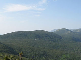
Mount Madison is a 5,367-foot (1,636 m) mountain in the Presidential Range of New Hampshire in the United States. It is named after the fourth U.S. President, James Madison.

Mount Lafayette is a 5,249-foot (1,600 m) mountain at the northern end of the Franconia Range in the White Mountains of New Hampshire, United States. It lies in the town of Franconia in Grafton County, and appears on the New England Fifty Finest list of the most topographically prominent peaks in New England. The mountain's upper reaches are located in the alpine zone, an area where only dwarf vegetation exists due to the harsh climate.

Carter Dome, or simply The Dome, is a mountain located in Coos County, New Hampshire. The mountain is part of the Carter-Moriah Range of the White Mountains, which runs along the northern east side of Pinkham Notch. Carter Dome is flanked to the northeast by Mount Hight and to the southwest by Wildcat Mountain.

Mount Moosilauke is a 4,802-foot-high (1,464 m) mountain at the southwestern end of the White Mountains in the town of Benton, New Hampshire, United States. It is the tenth highest and most southwesterly of the 4,000 foot summits in the White Mountains.

Mount Monroe is a 5,372-foot-high (1,637 m) mountain peak southwest of Mount Washington in the Presidential Range of the White Mountains in New Hampshire, United States. It is named for American President James Monroe and is the fourth highest mountain on the 4000 footers list for New Hampshire. The Appalachian Trail skirts its summit, which is the next highest peak on or near the trail north of Mount Rogers in Virginia. The Lakes of the Clouds, and its AMC hut, lie nestled at the col between Mount Monroe and neighboring Mount Washington.
Mount Pierce is a mountain in the Presidential Range in the White Mountains of New Hampshire that is approximately 4,310 feet (1,310 m) high. Formerly called Mount Clinton for 19th-century governor DeWitt Clinton of New York, in 1913 it was renamed after President Franklin Pierce (1804–1869), the only president born in New Hampshire, although it was several decades before the name was widely recognized. Its summit offers a wide view of New Hampshire's mountains.

Mount Hancock is a mountain in Grafton County, New Hampshire, named after John Hancock (1737–1793), one of the Founding Fathers of the United States.

Boott Spur is a minor peak located in Coos County, New Hampshire. The mountain is named after Francis Boott (1792–1863), and is part of the Presidential Range of the White Mountains. Boott Spur stands on the shoulder of Mount Washington, above the south side of the headwall of Tuckerman Ravine.
Mount Isolation is a mountain located in Coos County, New Hampshire. The mountain is part of the Presidential Range of the White Mountains. Mount Isolation is the highest peak on the Montalban Ridge which extends south from Boott Spur.
Mount Franklin is a mountain in Coös County, New Hampshire, United States. The mountain is named after Benjamin Franklin and is part of the Presidential Range of the White Mountains. Note that Ben Franklin was not a president. Mount Franklin is flanked to the northeast by Mount Monroe, and to the southwest by Mount Eisenhower.

Mount Garfield is a mountain located in Grafton County, New Hampshire. The mountain is part of the White Mountains. Mt. Garfield is flanked to the east by South Twin Mountain, and to the southwest along Garfield Ridge by Mount Lafayette.

Kearsarge North is a mountain located about 4 miles (6 km) northeast of North Conway, Carroll County, New Hampshire. The U.S. Board on Geographic Names accepted the name "Pequawket Mountain" in 1915 but it was renamed Kearsarge North in 1957. The Pequawket are a subdivision of the Abenaki people who formerly lived in the area. It is sometimes referred to as Mount Kearsarge, a name officially assigned to a mountain in Merrimack County.

Little Haystack Mountain is a peak on the Franconia Range of the White Mountains located in Grafton County, New Hampshire. It is flanked to the north by Mount Lincoln and to the southwest by Mount Liberty.
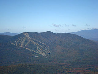
Mount Tecumseh is a mountain located in Grafton County, New Hampshire. The mountain is named after the Shawnee leader Tecumseh, and is a part of the White Mountains. The east side of Tecumseh drains into the Mad River; the west side drains into several brooks. All are tributaries of the Pemigewasset River, which drains into the Merrimack River and thence into the Gulf of Maine in Massachusetts.

Mount Hale is a mountain located in Grafton County, New Hampshire. The mountain is named after Reverend Edward Everett Hale (1822–1909), and is part of the Twin Range of the White Mountains. The western and eastern sides of Mount Hale are drained by the Little River and Zealand River respectively, and thence into the Ammonoosuc River, Connecticut River, and into Long Island Sound in Connecticut.
Mount Guyot is a mountain located in Grafton County, New Hampshire. The mountain is named after Professor Arnold H. Guyot (1807–1884) of Princeton University, and is part of the Twin Range of the White Mountains. Mount Guyot is flanked to the northwest by South Twin Mountain, to the northeast by Mount Zealand, and to the south by Mount Bond. Guyot is on the northern boundary of the Pemigewasset Wilderness. The immediate area around the summit consists of high-altitude spruce-fir forest or krummholz.
Little Monadnock Mountain, 1,900 feet (579 m), is located in the towns of Fitzwilliam and Troy, New Hampshire. Most of the mountain is located within Rhododendron State Park; there are scenic vistas from ledges just below the summit. The 110 mile Metacomet-Monadnock Trail crosses the mountain.

The Crawford Path is an 8.5-mile-long (13.7 km) hiking trail in the White Mountains of New Hampshire that is considered to be the United States' oldest continuously maintained hiking trail. It travels from Crawford Notch to the summit of Mount Washington (Agiocochook). The first iteration of the Crawford Path was cut in 1819 by Ethan Allen Crawford and his father, Abel Crawford. The trail ascends a cumulative 4,900 feet (1,500 m), first through densely wooded forest for about 3.1 miles (5.0 km), then following the exposed southern ridge of the Presidential Range mostly above the treeline.

