Mount Jefferson (Madison County, Montana)

Last updated
Mount Jefferson
Hollowtop 2008.jpg
Mt Jefferson and Hollowtop
Highest point
Elevation 10,513 ft (3,204 m) [1]
Prominence 393 ft (120 m) [1]
Coordinates 45°36′10″N112°00′21″W / 45.60278°N 112.00583°W / 45.60278; -112.00583
Geography
USA Montana relief location map.jpg
Red triangle with thick white border.svg
Mount Jefferson
Parent range Tobacco Root
Topo map USGS Noble Peak, MT
Climbing
Easiest route Hike

Mount Jefferson is a mountain in the U.S. state of Montana, and is one of the many 10,000+ ft peaks in the Tobacco Root Mountains. The mountain is located in Beaverhead-Deerlodge National Forest. (There is also another Mount Jefferson in Montana, further south, on the Idaho/Montana border.) Hollowtop Mountain is an adjacent, taller peak less than .75 miles (1.2 km) to the north. Over the years, the two summits have had numerous names and elevations recorded on various maps. According to U.S. Geological Survey topographic maps, Mount Jefferson is 10,513 ft (3,204 m), while Hollowtop Mountain to the north is 10,604 ft (3,232 m). [2]

Contents

Nomenclature

The nomenclature for Mount Jefferson has seen considerable change and confusion over the years. A.N. Winchell, in his 1914 report, Mining Districts of the Dillon Quadrangle, referred to the highest peak in the Tobacco Roots as "Jefferson Peak, locally called Old Hollowtop." Since that time the more northerly, and higher, of the two adjacent peaks has usually been called Hollowtop. This naming convention is easily explained upon viewing the dish-shaped northeasterly-trending glacial cirque that occupies the top of Hollowtop peak. Information is scanty before 1914. Peale (1896) referred to Ward Peak, near Pony, and “unnamed high peaks” in the range. Present local terminology places Ward Peak further south, near McAlister. The idea that Lewis and Clark named the ranges along with the rivers cannot be confirmed.

Some earlier, published maps labeled the northern peak as Mt. Jefferson. Confusion may arise from the fact that the horizontal triangulation control station (VABM) named JEFFERSON is located on the southern peak, and this designation is found on many maps.

In 1933, Tansley and others referred to the high point of the range as Mt. Jefferson, at 10,600 ft. The northern peak was labeled Mt. Jefferson on the Gallatin National Forest map of 1937, with an erroneous (but long-perpetuated) elevation of 10,740’ given. The southern peak was called Hollow Top Mountain, at 10,513’. The next year, 1938, the Deerlodge National Forest map dodged the issue: the northern peak received two designations — Hollowtop Mtn. and Mt. Jefferson. The southern peak was labeled with the JEFFERSON control station only.

Reid in 1957 mapped the northern peak as Mt. Jefferson and the southern one as Goat Mountain. In 1960, the Waterloo 15-minute topographic quad showed Mt. Jefferson, to the north, at 10,604’, and the southern one as Hollowtop Mtn (10,513’) with the JEFFERSON control station label. In 1976, the U.S. Board on Geographic Names stated that this was the correct designation. The 1962 Dillon Quad (1:250,000) labeled the northern peak Hollow Top Mt., and the other one had no designation other than the triangular control station mark. The 1963 Beaverhead National Forest map shows Mt. Jefferson to the north at 10,604’ and the JEFFERSON control station to the south at 10,740’, while the 1970 Deerlodge National Forest map is similar, but with the name Hollowtop Mtn. and no elevation for the southern peak.

Oil Company highway maps from the late 1960s and early 1970s show Hollowtop Mtn. at 10,740’, while the Official Montana Highway Map, from at least 1971 onwards, has Hollow Top Mtn. at 10,604’. As recently as 1976, the Beaverhead National Forest map showed Mt. Jefferson to the north (10,604’) and Hollowtop Mtn. with the JEFFERSON control station to the south.

In 1987, the Interagency Visitors Map of Southwest Montana (produced by the Forest Service, USGS, and State of Montana) shows the northern peak labeled Hollowtop Mtn. (10,604’), and the southern peak is marked Mt. Jefferson and includes the control station label. This is the first map known that shows both names, with Hollowtop north of Mt. Jefferson.

Finally, the 1989 7½-minute quad (Noble Peak) also shows Hollowtop Mountain (10,604’) to the north, with Mt. Jefferson (10,513’) to the south with the control station. Numerous hand-held GPS measurements indicate that these listed elevations are probably accurate.

Apparently no peak has an elevation of 10,740’, and all sources agree that the JEFFERSON triangulation station is on the southern peak. Decades of use would have “Hollowtop” to the north, and perhaps the newer maps reflect this usage. The northern peak is labeled “Hollowtop” and “Hollow Top” on various maps, with a single word somewhat more common.

Geology

Most of the mountain is underlain by the Tobacco Root Batholith, a body of granite intruded about 75 million years ago during the Late Cretaceous Period. The Tobacco Root Batholith is often called a satellite of the much larger Boulder Batholith. Parts of Mt. Jefferson-Hollowtop contain Archean metamorphic rocks. Intrusion of the batholith produced considerable mineralization along northwest-trending faults. The Mammoth Mine, north of Mt. Jefferson-Hollowtop produced more than $2,000,000 in gold over its life (mostly in the 1880s-1910s). The Nicholson Gold Mine, on the west flank of Mt. Jefferson, has been active as recently as the middle 1990s, but no production has been reported. The area of the mine is private property, a patented mining claim.

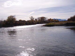
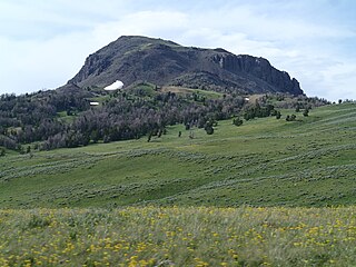
The bowl-like crest of Hollowtop, best viewed from the towns of Pony, Montana and Harrison, Montana to the east, is not a classical glacial cirque. Snow and perhaps ice certainly accumulated there during the ice age, but scouring typical of a moving glacier is not evident.

Related Research Articles

<span class="mw-page-title-main">Jefferson River</span> River in Montana, United States

The Jefferson River is a tributary of the Missouri River, approximately 83 miles (134 km) long, in the U.S. state of Montana. The Jefferson River and the Madison River form the official beginning of the Missouri at Missouri Headwaters State Park near Three Forks. It is joined 0.6 miles (1.0 km) downstream (northeast) by the Gallatin.

The Boulder River is a 77-mile (124 km) tributary of the Jefferson River in southwestern Montana in the United States.

<span class="mw-page-title-main">Beaverhead–Deerlodge National Forest</span> National Forests in Montana, United States

The Beaverhead–Deerlodge National Forest is the largest of the National Forests in Montana, United States. Covering 3.36 million acres (13,600 km2), the forest is broken into nine separate sections and stretches across eight counties in the southwestern area of the state. President Theodore Roosevelt named the two forests in 1908 and they were merged in 1996. Forest headquarters are located in Dillon, Montana. In Roosevelt's original legislation, the Deerlodge National Forest was called the Big Hole Forest Reserve. He created this reserve because the Anaconda Copper Mining Company, based in Butte, Montana, had begun to clearcut the upper Big Hole River watershed. The subsequent erosion, exacerbated by smoke pollution from the Anaconda smelter, was devastating the region. Ranchers and conservationists alike complained to Roosevelt, who made several trips to the area. (Munday 2001)

<span class="mw-page-title-main">Bitterroot National Forest</span> U.S. Forest across Montana and Idaho

Bitterroot National Forest comprises 1.587 million acres (6,423 km²) in west-central Montana and eastern Idaho, of the United States. It is located primarily in Ravalli County, Montana, but also has acreage in Idaho County, Idaho (29.24%), and Missoula County, Montana (0.49%).

<span class="mw-page-title-main">Anaconda–Pintler Wilderness</span> Protected wilderness area in Montana, United States

The Anaconda–Pintler Wilderness is located in southwestern Montana, in the northwestern United States. It runs for 40 miles (64 km) along both sides of the crest of the Anaconda Range, covering almost 250 square miles (650 km2). To the north are the Sapphire Mountains, and to the south is the Big Hole Valley. Elevations range from about 5,000 feet (1,500 m) up to 10,793 feet (3,290 m) at West Goat Peak. West Pintler Peak, located in a more commonly visited area, rises to 9,894 feet (3,016 m). Visitors can most easily access this area via trailheads at Pintler Lake to the south, and at Lutz Creek and Moose Lake to the north. The wilderness lies in parts of Deer Lodge, Granite, Ravalli, and Beaverhead counties.

<span class="mw-page-title-main">Tobacco Root Mountains</span> Mountain in the state of Montana

The Tobacco Root Mountains lie in the northern Rocky Mountains, between the Jefferson and Madison Rivers in southwest Montana. The highest peak is Hollowtop at 10,604 feet (3,232 m). The range contains 43 peaks rising to elevations greater than 10,000 feet (3048 m).

<span class="mw-page-title-main">Bull of the Woods Wilderness</span>

The Bull of the Woods Wilderness is a wilderness area located in the Mount Hood National Forest in the northwestern Cascades of Oregon, United States. It was created in 1984 and consists of 37,607 acres (15,219 ha) including prime low-elevation old-growth forest, about a dozen lakes of at least 1-acre (4,000 m2) and many large creeks and streams. Adjacent areas, including Opal Creek Wilderness to the west, create a pristine area of nearly 84 square miles (218 km2). There are seven trails that access the wilderness area with an additional seven trails within the protection boundaries themselves. Combined the system provides 75 miles (121 km) of challenging terrain for both pedestrian and equestrian recreation. The name of the peak and thus the wilderness area comes from logging jargon in which the "bull of the woods" was the most experienced logging foreman in an operation.

<span class="mw-page-title-main">Hilgard Peak</span> Mountain in Montana, United States

Hilgard Peak is the tallest mountain in the Madison Range in the U.S. state of Montana. The summit is located in a remote section of the Lee Metcalf Wilderness within the Beaverhead-Deerlodge National Forest. The peak was first climbed in 1948. The peak was named for E. W. Hilgard, a geology professor who served on the Hayden Expedition during its exploration of the Yellowstone area.

<span class="mw-page-title-main">Gravelly Range</span> Mountain range in the state of Montana

The Gravelly Range, highest peak Black Butte, el. 10,542 feet (3,213 m), is a mountain range southwest of Cameron, Montana in Madison County, Montana.

The John Long Mountains, el. 7,923 feet (2,415 m), is a small mountain range northwest of Philipsburg, Montana in Granite County, Montana. The Beaverhead-Deerlodge National Forest and Lolo National Forest manage these mountains. A sizable roadless area of about 65,000 acres existed, as of 1990, in the John Long Mountains, centered on Silver King Mountain in the southern part of the range. It's unknown whether and to what extent this area's size has been reduced by logging. Lightly used trails traverse whitebark pine forests on the higher ridges, and forests of lodgepole pine, Douglas-fir, and heavy downfall on the eastern slopes. The western slopes have groves of douglas-fir amidst extensive grassy parks. Silver King Mountain is 7,581'.

The Ruby Range is a mountain range in Madison and Beaverhead counties Montana. The range lies east of Dillon and southwest of Sheridan. The highest point, Ruby Peak with an elevation of 9,391 feet (2,862 m), lies in the northeast portion of the range. Gordon Peak with an elevation of 8,478 ft (2,584 m) lies in the southwest part of the range to the southeast of Dillon. The range is oriented NE–SW with a length of about 42.7 kilometres (26.5 mi). The Beaverhead River lies to the northwest of the range. Ruby River runs along the southeast and east flanks of the range with Ruby Reservoir on the southeast flank. Blacktail Deer Creek drains the southwest portion of the range and the Blacktail Mountains lie to the southwest. The Tobacco Root Mountains and the Greenhorn Range lie to the northeast and east respectively.

<span class="mw-page-title-main">Table Mountain (Madison County, Montana)</span>

Table Mountain, el. 10,213 feet (3,113 m) is the highest peak in the Highland Mountains in Madison County, Montana. It is located in Beaverhead-Deerlodge National Forest. Headwaters of Moose Creek, Fish Creek and Hell's Canyon Creek, all significant tributaries of the Jefferson River flow off the face of the mountain.

Koch Peak is the one of the taller mountains in the Madison Range in the U.S. state of Montana. The summit is located in Lee Metcalf Wilderness within Gallatin and Beaverhead-Deerlodge National Forests. Koch Peak is tallest in a group of summits collectively called the Taylor Peaks.

Echo Peak is the one of the taller mountains in the Madison Range in the U.S. state of Montana. The summit is located in Lee Metcalf Wilderness within Gallatin and Beaverhead-Deerlodge National Forests. Echo Peak is less than 2 mi (3.2 km) north of Hilgard Peak.

Imp Peak is in the Madison Range in the U.S. state of Montana. The summit is located in Lee Metcalf Wilderness within Gallatin and Beaverhead-Deerlodge National Forests. Echo Peak is 3.1 mi (5.0 km) south of Koch Peak.

<span class="mw-page-title-main">Lone Mountain (Montana)</span> Mountain in the state of Montana

Lone Mountain is in the Madison Range in the U.S. state of Montana. The summit is located in Lee Metcalf Wilderness within Gallatin and Beaverhead-Deerlodge National Forests. Lone Mountain is 16.63 mi (26.76 km) north of Koch Peak.

Gallatin Peak is a summit located in the Madison Range in the U.S. state of Montana. The summit is located in Lee Metcalf Wilderness within Gallatin and Beaverhead-Deerlodge National Forests.

References

  1. 1 2 "Mount Jefferson, Montana". Peakbagger.com. Retrieved 2010-04-13.
  2. "Mount Jefferson, USGS Noble Peak (MT) Topo Map" (Map). TopoQuest. Retrieved 2008-06-29.