
Indonesia is an archipelagic country located in Southeast Asia and Oceania, lying between the Indian Ocean and the Pacific Ocean. It is located in a strategic location astride or along major sea lanes connecting East Asia, South Asia and Oceania. Indonesia is the largest archipelago in the world. Indonesia's various regional cultures have been shaped—although not specifically determined—by centuries of complex interactions with its physical environment.

The Bromo, or Mount Bromo is an active somma volcano, a Hindu pilgrimage site, and part of the Tengger mountains, in East Java, Indonesia. At 2,329 meters (7,641 ft) it is not the highest peak of the massif, but is the most active and famous. The area is one of the most visited tourist destinations in East Java, and the volcano is included in the Bromo Tengger Semeru National Park. The name Bromo comes from the Javanese pronunciation of Brahma, the Hindu god of creation. At the mouth of the crater, there is an idol of Ganesha, the Hindu god of wisdom which is being worshipped by the Javanese Hindus. Mount Bromo is located in the middle of a plain called "Sea of Sand", a nature reserve that has been protected since 1919.

South Sumatra is a province of Indonesia, located in the southeast of the island of Sumatra. The capital and largest city of the province is the city of Palembang. The province borders the provinces of Jambi to the north, Bengkulu to the west and Lampung to the south, as well a maritime border with the Bangka Belitung Islands to the east. It is the largest province in the island of Sumatra, and it is slightly smaller than Portugal, the department of Boquerón in Paraguay or the U.S. state of Maine. The Bangka Strait in the east separates South Sumatra and the island of Bangka, which is part of the Bangka Belitung Islands province. The province has an area of 91,592.43 km2 (35,364 sq mi) and had a population of 8,467,432 at the 2020 Census; the official estimate as at mid-2023 was 8,743,522. The province is rich in natural resources, such as petroleum, natural gas and coal. The province is inhabited by many different malay sub ethnic groups, with Palembangese being largest ethnic group. Most speak the Palembang language, which is mutually intelligible to both Indonesian and local Palembang Malay. Other ethnic groups include the Javanese, Sundanese, Minangkabau and Chinese. Most are concentrated in urban areas and are largely immigrants from other parts of Indonesia.

Bengkulu, historically known as Bencoolen, is a province of Indonesia. It is located on the southwest coast of Sumatra. It was formed on 18 November 1968 by separating out the area of the historic Bencoolen Residency from the province of South Sumatra under Law No. 9 of 1967 and was finalized by Government Regulation No. 20 of 1968. Spread over 20,130.21 km2, its area is comparable to the European country of Slovenia and it is bordered by the provinces of West Sumatra to the north, Jambi to the northeast, Lampung to the southeast, and South Sumatra to the east, and by the Indian Ocean to the northwest, south, southwest, and west.

Mount Kerinci, also spelled Kerintji, is an active stratovolcano and the highest mountain in Sumatra, Indonesia. At 12,484 ft (3,805 m) above sea level, it provides Sumatra with the fifth-highest maximum elevation of any island in the world. It is surrounded by the lush forest of Kerinci Seblat National Park, home to several endangered species including the Sumatran tiger. Mount Kerinci is ranked 32nd by topographic isolation.

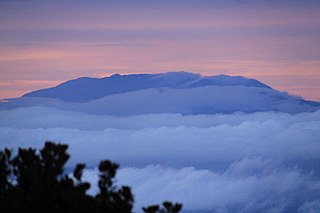
Mount Agung is an active volcano in Bali, Indonesia, southeast of Mount Batur volcano, also in Bali. It is the highest point on Bali, and dominates the surrounding area, influencing the climate, especially rainfall patterns. From a distance, the mountain appears to be perfectly conical. From the peak of the mountain, it is possible to see the peak of Mount Rinjani on the nearby island of Lombok, to the east, although both mountains are frequently covered in clouds. Agung is a stratovolcano, with a large and deep crater. Its most recent eruptions occurred from 2017–2019.

Mount Rinjani is an active volcano in Indonesia on the island of Lombok. Administratively the mountain is in the Regency of North Lombok, West Nusa Tenggara. It rises to 3,726 metres (12,224 ft), making it the second highest volcano in Indonesia. It is also the highest point in the Indonesian province of West Nusa Tenggara. Adjacent to the volcano is a 6-by-8.5-kilometre caldera, which is filled partially by the crater lake known as Segara Anak or Anak Laut, due to the color of its water, as blue as the sea (laut). This lake is approximately 2,000 metres (6,600 ft) above sea level and estimated to be about 200 metres (660 ft) deep; the caldera also contains hot springs. The lake and mountain are sacred to the Sasak people and Hindus, and are the site of religious rituals. UNESCO made Mount Rinjani Caldera a part of the Global Geoparks Network in April 2018.

Anak Krakatau is a volcanic island in Indonesia. On 29 December 1927, Anak Krakatau first emerged from the caldera formed in 1883 by the explosive volcanic eruption that destroyed the island of Krakatoa. There has been sporadic eruptive activity at the site since the late 20th century, culminating in a large underwater collapse of the volcano, which caused a deadly tsunami in December 2018. There has been subsequent activity since. Owing to its young age the island is one of several in the area that are of interest to, and the subject of extensive study by volcanologists.

Karangetang, also known as Api Siau is a volcano on the north side of Siau Island off the coast of Sulawesi, Indonesia. The island covers 160 km2, and had 46,459 inhabitants in mid 2023. It is one of the most active volcanoes in Indonesia, having erupted 41 times since 1675. A pyroclastic flow in 1997 killed three people. Karangetang is the tallest mountain in offshore North Sulawesi, at 1827 meters above sea level.
Leuser Range or MountLeuser is a stratovolcano located in the Aceh province on the island of Sumatra, Indonesia. It is part of the Leuser Ecosystem, which is one of the most biodiverse regions in the world and a key conservation area for endangered species.

Mount Matutum is an active stratovolcano, is the highest point in the province of South Cotabato in the Philippines, with an elevation of 7,500 feet above sea level, approximately 5.7 kilometres (3.5 mi) from Acmonan, Tupi, South Cotabato. Matutum and its foothills are predominantly inhabited by indigenous Blaan families.
Peuet Sague is a volcanic complex in the northwestern part of Sumatra, Indonesia. The name peuet sagoe in Acehnese means four square. The location of the volcanic complex is isolated that needs several journeys on foot from the nearest village to reach the mountain. There are four summits in the complex that all of them are located in Pidie Regency, Aceh Province. One of the lava dome is called Mount Tutung and it has 70 metres (230 feet) diameter and 80 meters (262.5 feet) deep of an active crater.

Mount Sinabung is a Pleistocene-to-Holocene stratovolcano of andesite and dacite in the Karo plateau of Karo Regency, North Sumatra, Indonesia, 40 kilometres (25 mi) from the Lake Toba supervolcano. Many old lava flows are on its flanks and the last known eruption, before recent times, occurred 1200 years before present, between 740 - 880 CE. Solfataric activities were last observed at the summit in 1912; recent documented events include an eruption in the early hours of 29 August 2010 and eruptions in September and November 2013, January, February and October 2014. The volcano has recently claimed the life of at least 23 people in a number of events since 2014. Between 2013 and 2014, the alert for a major event was increased with no significant activity. On 2 June 2015, the alert was again increased, and on 26 June 2015, at least 10,000 people were evacuated, fearing a major eruption. The long eruption of Mount Sinabung is similar to that of Mount Unzen in Japan, which erupted for five years after lying dormant for 400 years. A major eruption began on 10 August 2020.

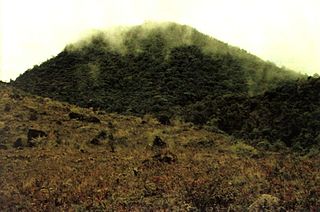
Mount Dempo is the highest stratovolcano in South Sumatra province that rises above Pasumah Plain near Pagar Alam and adjacent with Bengkulu Province. Seven craters are found around the summit. A 400-metre (1,300 ft) wide lake is found at the north-west end of the crater complex.

Bromo Tengger Semeru National Park is a national park located in East Java, Indonesia, to the east of Malang and Lumajang, to the south of Pasuruan and Probolinggo, and to the southeast of Surabaya, the capital of East Java. It is the only conservation area in Indonesia that has a sand sea, the Tengger Sand Sea, across which is the caldera of an ancient volcano (Tengger) from which four new volcanic cones have emerged. This unique feature covers a total area of 5,250 hectares at an altitude of about 2,100 meters (6,900 ft). The massif also contains the highest mountain in Java, Mount Semeru, four lakes and 50 rivers. It is named after the Tengger tribe. The explosion of the volcano that created the caldera, happened ca. 45.000 years ago, in an event similar to the Krakatau eruption.

Mount Talinis is a complex volcano in the Philippine province of Negros Oriental. At about 1,903 metres (6,243 ft) above sea level, it is the second highest mountain on Negros Island after Mount Kanlaon, and the tallest peak in the mountain range known as the Cuernos de Negros. The volcano is located 9 km (5.6 mi) southwest of the municipality of Valencia; and 20 km (12 mi) from Dumaguete, the capital of the province.
The Nevado de Toluca National Park is located southwest of the city of Toluca, Mexico State. It was decreed a park in 1936, primarily to protect the Nevado de Toluca volcano, which forms nearly the park's entire surface and is the fourth highest peak in Mexico. It is 45 km from Toluca and 135 from Mexico City. The park was established with the aim of conservation, but the park is under increasing pressure from the growth of the Toluca metropolitan area as well as from illegal logging done by local communities who need the income. The volcano has been long extinct and has a large crater in which are two shallow lakes. The crater and lakes are popular with visitors from Mexico State and Mexico City, especially when there is snow. There are a number of archeological sites in the park, including the lakes themselves, which contain numerous offerings of copal and other items that were deposited during the pre-Hispanic period. The park offers activities such as hiking, mountain biking and horseback riding as well as limited skiing facilities. Due to its altitude, the summit of the Nevado is significantly colder than the surrounding area.
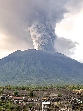
Mount Agung, a volcano on the island of Bali in Indonesia, erupted five times in late November 2017, causing thousands to evacuate, disrupting air travel and causing environmental damage. As of 27 November 2017, the alert level was at its highest and evacuation orders were in place.

Mount Matsurai, natively known as Gunung Masurai, is a large complex of inactive stratovolcanoes in Jambi, Sumatra, Indonesia. The volcano attains an elevation of 2,916 m (9,567 ft) above sea level.

