Mount Tamborine, Queensland

Last updated

Mount Tamborine
Queensland
Australia Queensland location map.svg
Red pog.svg
Mount Tamborine
Coordinates 27°58′21″S153°11′52″E / 27.9725°S 153.1977°E / -27.9725; 153.1977 (Mount Tamborine (town centre)) Coordinates: 27°58′21″S153°11′52″E / 27.9725°S 153.1977°E / -27.9725; 153.1977 (Mount Tamborine (town centre))
Population1,184 (2006 census) [1]
Established1875
Postcode(s) 4272
Time zone AEST (UTC+10:00)
LGA(s) Scenic Rim Region
State electorate(s) Scenic Rim
Federal Division(s) Wright

Mount Tamborine is a town within the locality of Tamborine Mountain in South East Queensland, Australia. [2] [3]

Contents

History

Mount Tamborine Post Office opened by March 1924 (a receiving office had been open from 1881, originally known as Tambourine Mountain), was renamed Mount Tamborine in 1926 and closed in 1977. [4]

The name "Tamborine" is taken from the Yugembah language for "wild lime", after the finger lime trees in the area. Tamborine was sometimes spelt as "tchambreem", "jambreen" and "goombireen".

Formerly a suburb in its own right, in 1997, Mount Tamborine was merged with other former suburbs North Tamborine and Eagle Heights to create the larger locality of Tamborine Mountain. [5] All three suburbs now have the postcode 4272 and postal address of Tamborine Mountain. The postcode 4271 is reserved for the Post Office at Eagle Heights.

At the 2006 census Mount Tamborine had a population of 1,184. [1] There has not been any census data reported for the town of Mount Tamborine after 2006.

Heritage listings

Mount Tamborine has a number of heritage-listed sites, including:

See also

Related Research Articles

Tamborine National Park Protected area in Queensland, Australia

Tamborine is a national park in the Gold Coast hinterland and is a part of the Scenic Rim Regional Council of South East Queensland, Australia, 45 km (28 mi) south of Brisbane.

Mount Perry, Queensland Town in Queensland, Australia

Mount Perry is a small town and locality in the North Burnett Region in southeastern Queensland, Australia. In the 2016 census, Mount Perry had a population of 538 people. The neighbourhood of Drummers Creek is in the locality.

Mount Garnet, Queensland Town in Queensland, Australia

Mount Garnet is a rural town and locality in the Tablelands Region, Queensland, Australia. In the 2016 census, Mount Garnet had a population of 430 people.

Landsborough, Queensland Town in Queensland, Australia

Landsborough is a town and a locality in the Sunshine Coast Region, Queensland, Australia. In the 2016 census, Landsborough had a population of 3,812 people.

Babinda Town in Queensland, Australia

Babinda is a small town and locality in the Cairns Region, Queensland, Australia. It is located 60 kilometres (37 mi) south of Cairns.

Baralaba, Queensland Town in Queensland, Australia

Baralaba is a rural town and locality in the Shire of Banana in central Queensland, Australia. In the 2016 census, Baralaba had a population of 314 people.

Mount Mulligan, Queensland Town in Queensland, Australia

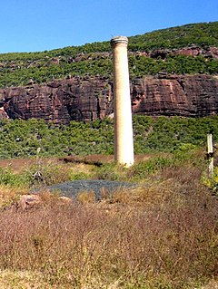
Mount Mulligan is a former mining town and now a rural locality in the Shire of Mareeba, Queensland, Australia. In the 2016 census Mount Mulligan had a population of 4 people.

Tamborine Mountain Suburb of Scenic Rim Region, Queensland, Australia

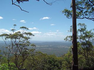
Tamborine Mountain is a 28 km2 (11 sq mi) plateau and locality in the Scenic Rim Region of South East Queensland, Australia. The name is of Aboriginal origin and is frequently misspelt as Tambourine but neither the name nor the place has any connection to the musical instrument. It is considered part of the Gold Coast hinterland and has a strong tourist industry.

Beerburrum, Queensland Town in Queensland, Australia

Beerburrum is a small town and coastal locality in the Sunshine Coast Region, Queensland, Australia. In the 2016 census, Beerburrum had a population of 763 people.

Goomeri Town in Queensland, Australia

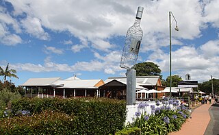
Goomeri is a town and locality in the Gympie Region, Queensland, Australia. In the 2016 census, Goomeri had a population of 664 people.

Inkerman, Queensland Town in Queensland, Australia

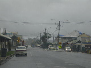
Inkerman is a rural town and locality in the Shire of Burdekin, Queensland, Australia. In the 2016 census, the locality of Inkerman had a population of 145 people.

Mount Surprise, Queensland Town in Queensland, Australia

Mount Surprise is a rural town and locality in the Shire of Etheridge, Queensland, Australia. In the 2016 census the locality of Mount Surprise had a population of 169 people.

North Tamborine, Queensland Town in Queensland, Australia

North Tamborine is a rural town in the locality of Tamborine Mountain in the Scenic Rim Region, Queensland, Australia.

Eagle Heights, Queensland Town in Queensland, Australia

Eagle Heights is a town within the locality of Tamborine Mountain in South East Queensland, Australia.

Clagiraba, Queensland Suburb of Gold Coast, Queensland, Australia

Clagiraba is a rural locality in the City of Gold Coast, Queensland, Australia. In the 2016 census, Clagiraba had a population of 601 people.

Mirani, Queensland Town in Queensland, Australia

Mirani is a town and locality in Mackay Region, Queensland, Australia. In the 2016 census, Mirani had a population of 1,541 people.

Mount Carbine, Queensland Town in Queensland, Australia

Mount Carbine is a rural town and locality in the Shire of Mareeba, Queensland, Australia. In the 2016 census, Mount Carbine had a population of 101 people.

Prince Henry Heights, Queensland Suburb of Toowoomba, Queensland, Australia

Prince Henry Heights is a residential locality on the outskirts of Toowoomba in the Toowoomba Region, Queensland, Australia. In the 2016 census, Prince Henry Heights had a population of 571 people.

Wonglepong, Queensland Suburb of Scenic Rim Region, Queensland, Australia

Wonglepong is a rural locality in the Scenic Rim Region, Queensland, Australia. In the 2016 census Wonglepong had a population of 341 people.

Mount Coolon, Queensland Suburb of Whitsunday Region, Queensland, Australia

Mount Coolon is a small town and locality in the Whitsunday Region, Queensland, Australia.

References

  1. 1 2 Australian Bureau of Statistics (25 October 2007). "Mount Tamborine (UCL)". 2006 Census QuickStats. Retrieved 27 January 2020.
  2. "Mount Tamborine – town in Scenic Rim Region (entry 23163)". Queensland Place Names. Queensland Government . Retrieved 27 January 2020.
  3. "Mount Tamborine – neighbourhood (entry 39794)". Queensland Place Names. Queensland Government . Retrieved 31 January 2016.
  4. Phoenix Auctions History. "Post Office List". Phoenix Auctions. Retrieved 21 February 2021.
  5. "Eagle Heights". Queensland Places. Centre for the Government of Queensland, University of Queensland. Retrieved 31 January 2016.
  6. "Tamborine Mountain Road/Geissmann Drive (entry 602365)". Queensland Heritage Register . Queensland Heritage Council. Retrieved 12 July 2013.