Mount Wise, Plymouth

Last updated

Mount Wise with 1770s Redoubt now containing a 40 m high mast erected in 1998 with circular viewing platform for recreational visitors, and statue of Winged Victory atop the Scott Memorial (distant right), commemorating the explorer Captain Robert Falcon Scott, Royal Navy, and others who died in March 1912 on their return from the South Pole. Behind the low white wall in the foreground is a series of small swimming pools Plymouth , Coastline - geograph.org.uk - 1146754.jpg
Mount Wise with 1770s Redoubt now containing a 40 m high mast erected in 1998 with circular viewing platform for recreational visitors, and statue of Winged Victory atop the Scott Memorial (distant right), commemorating the explorer Captain Robert Falcon Scott, Royal Navy, and others who died in March 1912 on their return from the South Pole. Behind the low white wall in the foreground is a series of small swimming pools

Mount Wise is a historic estate situated within the historic parish and manor of Devonport and situated about one mile west of the historic centre of the city of Plymouth, Devon. It occupies "a striking waterfront location" [1] with views across Plymouth Sound to Mount Edgcumbe and the English Channel. Until 2004 it was a headquarters for senior Admiralty staff and was inaccessible to the public. [2]

Contents

Manorial history

Prior to the establishment of the Royal Dockyard in 1690, a manor house known as Mount Wise was the only significant structure in the area. [3]

Wise

Arms of Wise of Sydenham and Mount Wise: Sable, three chevronels ermine WiseArms.png
Arms of Wise of Sydenham and Mount Wise: Sable, three chevronels ermine

In about 1400 the manor of Stoke Damerel, within which is situated Mount Wise, was inherited by Thomas Wise of Sydenham in the parish of Marystow in Devon, (son and heir of John Wise (fl.1403) of Sydenham, living in 1403 [4] ) upon his marriage to Margaret Brett (alias Brit), [5] daughter and heiress of Robert Brett of Staddiscombe, near Plymstock, [6] [7] [8] lord of the manor of Stoke Damerel. Thomas Wise also inherited from his wife the estates of Staddiscombe, Halgewell, Walford and Stoddon. [9]

The mansion house known as Mount Wise was built by Sir Thomas Wise (c.1576-1630), [10] Knight of the Bath, of Sydenham, Sheriff of Devon in 1612 who in 1621 served as a Member of Parliament for Bere Alston in Devon. He much beautified his principal seat of Sydenham House, and added such height and such a great amount of granite to it that his contemporary Risdon (d.1640) remarked: "the very foundation is ready to reel under the burthen". [11] His contemporary the Devon historian Sir William Pole (d.1635) remarked as follows concerning the manor of Stoke Damerel and Sir Thomas Wise (c.1576-1630):

"Hee hath bwilded heere, uppon an advanced ground a newe howse for his pleasure & named it Mount Wise, where Thomas (Wise) Esqr. his sonne now dwelleth, w(hi)ch hath married (Mary), daughter of Edward Lord Chichester, Vicont of Cairfergus".

His son, as Pole states, was Thomas Wise (c.1605-1641), who married Lady Mary Chichester, daughter of Edward Chichester, 1st Viscount Chichester of Carrickfergus in Ireland and of Eggesford in Devon. He was Sheriff of Devon in 1638 and in 1625 a Member of Parliament for Callington in Cornwall and for Bere Alston in the parliaments of King Charles of 1625, 1626 and 1628 to 1629, and for Devon twice in 1640. He named it "Mount Wise" following a common tradition shared by several estates particularly on the south coast of Devon, for example Mount Edgcumbe, Mount Galpin, [12] Mount Tavy, [13] Mount Radford, Mount Drake in the parish of Musbury, [14] Mount Dinham in Exeter, [15] Mount Batten [16] near Plymouth, Mount Boone, Mount Gold (Plymouth), [17] etc.

The son of the latter was Edward Wise (1632-1675) of Sydenham, thrice MP for Okehampton, who in 1667 sold the manor of Stoke Damerell for £11,600 [18] to Sir William Morice (1602-1676). Edward Wise (1632-1675) was predeceased by both his childless sons, and his sole heiress became his only daughter Arabella Wise, who married Edmund Tremayne (1649-1698) [19] of Collacombe in the parish of Lamerton on Devon, to which family passed Sydenham.

Morice

Arms of Morice: Gules, a lion rampant reguardant or MoriceArms.PNG
Arms of Morice: Gules, a lion rampant reguardant or

Sir William Morice (1602-1676) of Werrington in Devon, was Secretary of State for the Northern Department and a Lord of the Treasury from June 1660 to September 1668. Stoke Damerel and Mount Wise passed to his son [18] Sir William Morice, 1st Baronet (c. 1628–1690), who in turn was succeeded by his second son Sir Nicholas Morice, 2nd Baronet (c. 1681–1726). The latter's son was Sir William Morice, 3rd Baronet (c.17071750), who died without progeny and by his will dated 1744 bequeathed his estates to his nephew Sir John St Aubyn, 4th Baronet (1726–1772), [18] son of his sister Catherine Morice and her husband Sir John St Aubyn, 3rd Baronet (1696–1744).

St Aubyn

Arms of St Aubyn: Ermine, on a cross sable five bezants StAubyn (Molesworth-StAubyn Baronets) Arms.PNG
Arms of St Aubyn: Ermine, on a cross sable five bezants

Sir John St Aubyn, 4th Baronet (1726–1772), [18] was the son of Sir John St Aubyn, 3rd Baronet (1696–1744) by his wife Catherine Morice, sister and in her issue co-heoress of Sir William Morice, 3rd Baronet (c.17071750). The son of the 4th Baronet was Sir John St Aubyn, 5th Baronet (1758–1839), the owner of the estate in 1810 when it was stated of his inheritance of Stoke Damerel and Mount Wise: "The value of this property has probably increased as much as that of any landed property of its extent in the kingdom". [20] The population of the parish of Stoke Damerel, largely co-terminous with the manor, had increased from 3,361 in 1733 to 23,747 in 1800. The 5th Baronet's land in Stoke Damerel included the town of "Plymouth Dock", which he still owned in 1810, having sold to the government prior to that date the site of the Royal Dock Yard and the lines of military defence surrounding the town of "Plymouth Dock", [20] ("Devonport Dock Lines") which included Mount Wise.

Military use

Mount Wise indicated with yellow arrow on an 1851 map of Plymouth. The Royal Dockyard is to the immediate west (left), the whole complex being surrounded on the land side (north and east) by the "Devonport Dock Lines", a defensive wall visible on the map MountWise PlymouthMap 1851.png
Mount Wise indicated with yellow arrow on an 1851 map of Plymouth. The Royal Dockyard is to the immediate west (left), the whole complex being surrounded on the land side (north and east) by the "Devonport Dock Lines", a defensive wall visible on the map

The defensive lines were in place by the mid-18th century. A large number of soldiers was required to man the defences; to house them, a series of square barracks was built around the perimeter in the late 1750s and early '60s.

Mount Wise Fort, Plymouth Dock, by William Hay, 1780. Mount Wise Fort, Plymouth Dock, by William Hay, 1780.jpg
Mount Wise Fort, Plymouth Dock, by William Hay, 1780.

With the Devonport Lines protecting the Dockyard from landward attack, Mount Wise provided the key vantage point for defending against an attack from the sea. An octagonal redoubt with stone walls was built on Mount Wise in the 1770s, forming an emplacement designed to house guns for the purpose of defending the Royal Dockyard. In 1806 a semaphore signalling station was built within it, the last of a series of 32 linking Plymouth with the Admiralty in London. In the 1960s much of the structure was demolished, but many relics survive such as the external walls, semi-circular metal racer rails for the guns, World War II barage balloon anchoring rings, ammunition recesses and iron rings for manoeuvring the heavy guns. [21] In 1998 a 40-metre-high (130 ft) mast was built, with circular viewing platform for recreational use by visitors, giving panoramic views, most notably westward to the Royal William Yard.

Government House (later known as Admiralty House) on Mount Wise: built in 1789-93, it initially served as home and headquarters of the military Governor of Plymouth. Admirality House, Devonport.jpg
Government House (later known as Admiralty House) on Mount Wise: built in 1789–93, it initially served as home and headquarters of the military Governor of Plymouth.

In the late 18th century, at the height of fears of a French invasion following the French Revolution (1789), a large house was built on Mount Wise to house the military Governor of Plymouth. To the north, it faced the southernmost of the barracks (St George's Square) across a large parade ground; to the south, it was given a large garden extending towards the sea. [3]

In 1804 an offshoot of the Royal Laboratory was set up on Mount Wise, just west of the redoubt, in buildings designed by Lewis Wyatt. The Royal Laboratory (established in Woolwich in the 17th century) was a department of the Board of Ordnance responsible for the manufacture and repair of small-arms ammunition. Between 1806 and 1814 some 70,000,000 cartridges were produced on Mount Wise and hundreds of men and boys were employed there; by the 1820s, the Napoleonic Wars having ended, the Laboratory had been reduced to a skeleton staff of five. In 1828, the Ordnance Board decided to close the Mount Wise Laboratory, citing the distance that had to be covered each day by the powder hoys that supplied the Laboratory with gunpowder from Keyham. [22] By 1834 the Laboratory buildings had been converted into barracks accommodation and they remained in military use well into the 20th century. [3]

Admiralty use

Royal Naval Signal Station (established at Mount Wise in 1810). R N Signal Station at Mount Wise Devonport Plymouth.jpg
Royal Naval Signal Station (established at Mount Wise in 1810).

Shortly before 1810 the estate together with the site of the Royal Dockyard was purchased by the Admiralty from Sir John St Aubyn, 5th Baronet (1758–1839), [20] due to its strategic location, and became the Royal Navy's Maritime Headquarters. [23] In the 19th-century it became the home of the Plymouth Garrison. [1] The estate of Mount Wise was used by the Admiralty for about 200 years until it was abandoned in 2004 and was sold in 2006 by the Defence Estates for £5.5million. [24] Security guards stop vandals from trespassing in the bunker buildings. [25]

Return to civilian usage

Mount Wise from Mount Edgcumbe (0116).jpg
Mount Wise from Mount Edgcumbe (0812).jpg
Mount Wise and the Scott Memorial, viewed from Mount Edgcumbe. Hamoaze House (centre left) and Admiralty House (far right, partly obscured by trees)

In 2011 the estate of Mount Wise comprising 28 acres of land started its phase one development as "The Village by the Sea", a residential area with 469 new houses, Admiralty House converted into a 21-bed "boutique hotel", 32,000 sq ft of offices, a 4,500 sq ft convenience store, the restoration of the former naval cricket pitch and pavilion and the nuclear bunker converted to a 50,000 sq ft data storage centre. [26] The development advisor stated: "We are not trying to build a city centre development; we will be creating a waterside village". [27] The new buildings were planned to have a "Georgian-inspired feel" with Admiralty House retained "as the figurehead of the scheme". [27] Phase one ended in 2012, but sales of the new properties were slow due to the continued effects of the 2008 global recession. [28]

The second phase of the development was due for completion in September 2015. [23] Mount Wise House has been turned into offices, not the hotel as planned in phase one.

Sources

Related Research Articles

Colebrooke is a village and parish in Devon, England about 8 km west of Crediton. The main point of interest is the church and the connection to Henry Kingsley's novel The Recollections of Geoffry Hamlyn. Also Uncle Tom Cobley, of the folk song, signed his will at Pascoe House, but is buried 4 miles west at Spreyton. The champion Devon wrestler, Abraham Cann was born and buried here. He won the all-comers wrestling crown in London.

<span class="mw-page-title-main">Umberleigh</span> Human settlement in England

Umberleigh is a former large manor within the historic hundred of (North) Tawton, but today a small village in North Devon in England. It used to be an ecclesiastical parish, but following the building of the church at Atherington it became a part of that parish. It forms however a part of the civil parish of Chittlehampton, which is mostly located on the east side of the River Taw.

<span class="mw-page-title-main">Werrington, Cornwall</span>

<span class="mw-page-title-main">Brixton, Devon</span> Village in Devon, England

Brixton is a village, parish and former manor situated near Plymouth in Devon, England. It is located on the A379 Plymouth to Kingsbridge road and is about 6 miles (9.7 km) from Plymouth. Its population is 1207.

<span class="mw-page-title-main">Tristram Risdon</span> English antiquarian and topographer

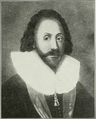
Tristram Risdon was an English antiquarian and topographer, and the author of Survey of the County of Devon. He was able to devote most of his life to writing this work. After he completed it in about 1632 it circulated around interested people in several manuscript copies for almost 80 years before it was first published by Edmund Curll in a very inferior form. A full version was not published until 1811. Risdon also collected information about genealogy and heraldry in a note-book; this was edited and published in 1897.

<span class="mw-page-title-main">Thomas Wise (died 1630)</span>

Sir Thomas Wise, KB, of Sydenham in the parish of Marystow and of Mount Wise in the parish of Stoke Damerel in Devon, was Sheriff of Devon in 1612 and in 1621 served as a member of parliament for Bere Alston in Devon.

<span class="mw-page-title-main">Thomas Wise (died 1641)</span>

Thomas Wise of Sydenham in Devon, was an English politician who sat in the House of Commons of England at various times between 1625 and 1641.

<span class="mw-page-title-main">Huntsham</span> Village in Devon, England

Huntsham is a small village and civil parish, formerly a manor and ecclesiastical parish, in the Mid Devon district of Devon, England. The nearest town is Tiverton, about 5.8 miles (9.3 km) south-west of the village. The parish is surrounded clockwise from the north by the parishes of Bampton, Hockworthy, Uplowman and Tiverton; it is bounded on the east by the River Lowman and by a minor road on Bampton Down to the north west, where it reaches a maximum height of 914 feet (279 m). In 2001 the population of the parish was 138, down from 222 in 1901.

<span class="mw-page-title-main">Fowelscombe</span>

Fowelscombe is a historic manor in the parish of Ugborough in Devon, England. The large ancient manor house known as Fowelscombe House survives only as an ivy-covered "romantic ruin" overgrown by trees and nettles, situated 1 mile south-east of the village of Ugborough. The ruins are a Grade II listed building.

<span class="mw-page-title-main">Sydenham House, Devon</span> Manor house in Devon, England

Sydenham House in the parish of Marystow in Devon, England, is a seventeenth-century manor house. The Grade I listed building is situated about thirteen miles south-west of Okehampton, on a 1,200 acres (490 ha) estate. It was built by Sir Thomas Wise (d.1629) between 1600 and 1612, incorporating an older structure. It was partially destroyed by fire in 2012. The gardens are Grade II listed in the National Register of Historic Parks and Gardens.

<span class="mw-page-title-main">Sharpham, Ashprington</span> Historic estate in Devon, England

Sharpham is an historic estate in the parish of Ashprington, Devon. The Georgian mansion house, known as Sharpham House, overlooks the River Dart and is a Grade I listed building. The house was commenced in about 1770 by the Royal Navy captain Philemon Pownoll to the designs of the architect Sir Robert Taylor (1714–1788). In the opinion of Nikolaus Pevsner it contains "one of the most spectacular and daring later 18th century staircase designs anywhere in England". The park and gardens are Grade II* listed in the National Register of Historic Parks and Gardens. Part of the descent of Sharpham is shown on the Palmes family heraldic pedigree roll.

<span class="mw-page-title-main">Thuborough</span> Historic estate in Devon, England

Thuborough in the parish of Sutcombe, Devon, England, is an historic estate, formerly a seat of a branch of the Prideaux family, also seated at Orcharton, Modbury; Adeston, Holbeton; Soldon, Holsworthy; Netherton, Farway; Ashburton; Nutwell, Woodbury; Ford Abbey, Thorncombe, all in Devon and at Prideaux Place, Padstow and Prideaux Castle, Luxulyan, in Cornwall. The present mansion house, comprising "Thuborough House" and "Thuborough Barton", the north-east block, is a grade II listed building.

<span class="mw-page-title-main">Manor of Ashton</span> Manor in England

The Manor of Ashton was a historic manor in Devonshire, England, of which the manor house was called Ashton House, in the parish of Ashton, situated about 6 miles south-west of Exeter, on the western slopes of the Haldon Hills. It was long the seat of the Chudleigh family, from about 1320 to 1745, which originated at the manor of Chudleigh, 3 miles south of Ashton, and for which was created the Chudleigh baronetcy in 1622. It was abandoned by Sir George Chudleigh, 4th Baronet who in 1735 built himself nearby a grand mansion named Haldon House, on the east side of the Haldon Hills, influenced by Buckingham House in London, and moved his residence there.

<span class="mw-page-title-main">John Chichester (died 1586)</span>

Sir John Chichester lord of the manor of Raleigh in the parish of Pilton, near Barnstaple, North Devon, was Sheriff of Devon in 1576/7 and/or in 1585 and died of gaol fever contracted whilst acting as a magistrate at the Lent Black Assizes of Exeter in 1586.

<span class="mw-page-title-main">Milton Abbot</span> Village in Devon, England

Milton Abbot is a village, parish, and former manor in Devon, 6 miles (9.7 km) north-west of Tavistock, Devon, and 6 miles (9.7 km) south-east of Launceston, Cornwall.

Sandridge is an historic estate in the parish of Stoke Gabriel in Devon, situated on high ground at the head of the River Dart estuary. The estate was originally encompassed on three sides by the river, which meanders along its border, leaving it on the east side. The present grade II* listed Italianate style Regency mansion house known as Sandridge House was built in 1805 by Lady Ashburton, to the design of John Nash.

<span class="mw-page-title-main">Sherford (near Kingsbridge)</span> Village in Devon, England

Sherford is a village and former civil parish and manor, now in the parish of Frogmore and Sherford, in the South Hams district, in the county of Devon, England. It is situated about 2 1/2 miles east of the town of Kingsbridge. It should not be confused with the new town Sherford to be built on the outskirts of Plymouth, about 18 miles to the north-west. The parish church is dedicated to Saint Martin of Tours. In 1961 the parish had a population of 258. On 1 April 1986 the parish was abolished and merged with parts of South Pool and Charleton to form "Frogmore and Sherford". Sherford was recorded in the Domesday Book as Sireford/Sirefort/Sireforda.

<span class="mw-page-title-main">Kenedon</span> Historic manor in Devon, England

Kenedon is an historic manor situated in the parish of Sherford in Devon.

Collacombe is an historic manor in the parish of Lamerton, Devon, England. The manor house survives as a grade I listed building, known as Collacombe Barton or Collacombe Manor (House).

<span class="mw-page-title-main">Hareston, Brixton</span> Historic estate in Devon, England

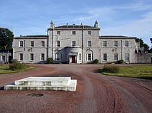
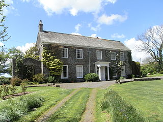
Hareston is an historic estate in the parish of Brixton, about three miles from Plymouth in Devon. The mansion house built during the reign of King Henry VII (1485-1509) burned down partially in an accidental fire at the beginning of the 18th century, and in 1822 the surviving part, the Hall and Chapel, was being used as a farmhouse. It was described by Candida Lycett Green in her 1991 book The Perfect English Country House as: "The most forgotten Manor House Farm In England, untouched for hundreds of years, sits safely, impossible to find, down miles of private sunken lanes which in the spring brim with Campion, Bluebells, Purple Orchids, Primroses, Violets, Speedwell and Stitchwort. Wooded hills rise behind this, the quintessence of an ancient English Manor House".

References

  1. 1 2 Devon Life, The Village by the Sea
  2. See photographs of interiors of derelict naval buildings at
  3. 1 2 3 "DEVONPORT CONSERVATION AREA APPRAISAL & MANAGEMENT PROPOSALS" (PDF). City of Plymouth. Retrieved 22 February 2018.
  4. regnal date 5 Henry IV, per Vivian, Lt.Col. J.L., (Ed.) The Visitations of the County of Devon: Comprising the Heralds' Visitations of 1531, 1564 & 1620, Exeter, 1895, p.791, pedigree of Wise
  5. Pole, p.332; Risdon, p.208
  6. "Stottiscombe", Vivian, Lt.Col. J.L., (Ed.) The Visitations of the County of Devon: Comprising the Heralds' Visitations of 1531, 1564 & 1620, Exeter, 1895, p.791, pedigree of Wise
  7. Pole, p.325, "Stottescombe"
  8. modern: Staddiscombe in Plymstock
  9. Pole, p.325
  10. Pole, p.332, who identifies the builder as the father of Thomas Wise (c.1605-1641), MP, who married Lady Mary Chichester, daughter of Edward Chichester, 1st Viscount Chichester of Carrickfergus in Ireland
  11. Risdon, Tristram (d.1640), Survey of Devon, 1811 edition, London, 1811, with 1810 Additions, p.219
  12. in Townstal parish, seat of Arthur Howe Holdsworth (1780–1860), MP
  13. Risdon, Tristram (d.1640), Survey of Devon, 1811 edition, London, 1811, with 1810 Additions, p.404; in 1810 the seat of John Philips Carpenter (Swete, John, Names of the Noblemen and Principal Gentlemen in the County of Devon, their Seats and Parishes at the Commencement of the Nineteenth Century, 1810, published in 1811 edition of Risdon, Tristram (d.1640), Survey of Devon, London, 1811, with 1810 Additions, p.3) father of John Carpenter Garnier (1839-1926), MP
  14. Risdon, p.24
  15. Pevsner, Nikolaus & Cherry, Bridget, The Buildings of England: Devon, London, 2004, p.435
  16. Pevsner, p.649
  17. Residence of Col. William II Gould (1615-1644) (No date given for his governorship in Vivian, Lt.Col. J.L., (Ed.) The Visitations of the County of Devon: Comprising the Heralds' Visitations of 1531, 1564 & 1620, Exeter, 1895, pp.344-6, pedigree of Floyer of Floyer Hayes, p.422) of Floyer Hayes, Exeter, Governor of Plymouth in 1644(Poulton-Smith, Anthony, South Devon Place Names)
  18. 1 2 3 4 Risdon, p.400
  19. Vivian, Lt.Col. J.L., (Ed.) The Visitations of the County of Devon: Comprising the Heralds' Visitations of 1531, 1564 & 1620, Exeter, 1895, p.732, pedigree of Tremayne
  20. 1 2 3 Risdon, 1810 Additions, p.400
  21. "Hidden Plymouth: Mount Wise Redoubt". 19 July 2012.
  22. Evans, David (2006). Arming the Fleet: The Development of the Royal Ordnance Yards 1770-1945. Gosport: Explosion! Museum and English Heritage.
  23. 1 2 http://www.plymouthherald.co.uk/plymouth-s-pound-13-5m-phase-mount-wise-housing/story-27544649-detail/story.html [ dead link ]
  24. Plymouth Herald, August 05, 2015, Plymouth's £13.5m Phase Two Mount Wise housing set for completion
  25. Mount Wise Navy Bunker Finally Busted
  26. Devon Life, The Village by the Sea, Mount Wise, Plymouth, Devon, 5 January 2011
  27. 1 2 Angus Macdonald, Development Advisor, Devon Life, The Village by the Sea
  28. Plymouth Herald, August 05, 2015, Plymouth's £13.5m Phase Two Mount Wise housing set for completion