Mountain Home, Idaho

Last updated

Mountain Home, Idaho
Turner House.jpg
Mountain Home, Idaho 2.jpg
Elmore county courthouse 2009.jpg
Panavia Tornado (Luftwaffe) at Mountain Home 096.jpg
Clockwise from top: Historic Turner Hotel, Elmore County Courthouse, Mountain Home Air Force Base, St. James Episcopal Church
Elmore County Idaho Incorporated and Unincorporated areas Mountain Home Highlighted 1654730.svg
Location of Mountain Home in Elmore County, Idaho
Coordinates: 43°8′13″N115°41′40″W / 43.13694°N 115.69444°W / 43.13694; -115.69444
CountryFlag of the United States.svg  United States
State Flag of Idaho.svg  Idaho
County Elmore
Government
  MayorRich Sykes [1]
Area
[2]
  Total6.35 sq mi (16.45 km2)
  Land6.06 sq mi (15.70 km2)
  Water0.29 sq mi (0.75 km2)
Elevation
3,146 ft (959 m)
Population
 (2020)
  Total15,979
  Density2,636.8/sq mi (1,018.1/km2)
Time zone UTC−7 (Mountain (MST))
  Summer (DST) UTC−6 (MDT)
ZIP code
83647
Area code 208
FIPS code 16-54730
GNIS feature ID0374044
Website mountain-home.us

Mountain Home is the largest city and county seat of Elmore County, Idaho, United States. [3] The population was 15,979 in the 2020 census. It is the principal city of the Mountain Home Micropolitan Statistical Area, which includes Elmore County.

Contents

Mountain Home was originally a post office at Rattlesnake Station, a stagecoach stop on the Overland Stage Line, about seven miles (11 km) east of the city, on present-day US-20 towards Fairfield. With the addition of the Oregon Short Line Railroad in 1883, the post office was moved downhill and west to the city's present site. [4] [5]

Mountain Home Air Force Base, an Air Combat Command installation, is located 12 miles (20 km) southwest of the city. Opened in 1943 during World War II, it was originally a bomber training base and later an operational Strategic Air Command bomber and missile base (1953–65). It switched to Tactical Air Command and fighters in January 1966, which was succeeded by Air Combat Command in 1992.

Geography

Foothills bordering the Danskin Mountains and Mount Bennett Hills. Rattlesnake Station was founded in this area. Mountain Home, Idaho USA - panoramio.jpg
Foothills bordering the Danskin Mountains and Mount Bennett Hills. Rattlesnake Station was founded in this area.

Mountain Home is located at 43°8′13″N115°41′40″W / 43.13694°N 115.69444°W / 43.13694; -115.69444 (43.136812, -115.694474), [6] at an elevation of 3,146 feet (959 m) above sea level.

According to the United States Census Bureau, the city has a total area of 6.36 square miles (16.47 km2), of which 6.07 square miles (15.72 km2) is land and 0.29 square miles (0.75 km2) is water. [7]

About 8 mi (13 km) to the northwest are the Crater Rings, a National Natural Landmark.

Mountain Home experiences a semi-arid climate (Köppen BSk) with short, cold winters and hot, dry summers.

Climate data for Mountain Home, Idaho, 1991–2020 normals, extremes 1906–2007
MonthJanFebMarAprMayJunJulAugSepOctNovDecYear
Record high °F (°C)66
(19)
72
(22)
82
(28)
94
(34)
107
(42)
107
(42)
115
(46)
109
(43)
107
(42)
94
(34)
79
(26)
67
(19)
115
(46)
Mean daily maximum °F (°C)40.0
(4.4)
46.6
(8.1)
55.7
(13.2)
62.8
(17.1)
73.7
(23.2)
84.1
(28.9)
95.0
(35.0)
93.2
(34.0)
81.9
(27.7)
67.1
(19.5)
50.1
(10.1)
39.1
(3.9)
65.8
(18.8)
Daily mean °F (°C)31.7
(−0.2)
36.2
(2.3)
43.0
(6.1)
49.4
(9.7)
59.1
(15.1)
68.0
(20.0)
77.3
(25.2)
75.4
(24.1)
64.9
(18.3)
51.9
(11.1)
39.3
(4.1)
31.2
(−0.4)
52.3
(11.3)
Mean daily minimum °F (°C)23.4
(−4.8)
25.9
(−3.4)
30.4
(−0.9)
35.9
(2.2)
44.6
(7.0)
51.9
(11.1)
59.6
(15.3)
57.6
(14.2)
48.0
(8.9)
36.7
(2.6)
28.4
(−2.0)
23.4
(−4.8)
38.8
(3.8)
Record low °F (°C)−29
(−34)
−18
(−28)
4
(−16)
1
(−17)
15
(−9)
20
(−7)
29
(−2)
26
(−3)
9
(−13)
7
(−14)
−10
(−23)
−36
(−38)
−36
(−38)
Average precipitation inches (mm)1.14
(29)
0.86
(22)
1.20
(30)
1.03
(26)
1.26
(32)
0.59
(15)
0.21
(5.3)
0.13
(3.3)
0.50
(13)
0.81
(21)
1.26
(32)
1.56
(40)
10.55
(268.6)
Average snowfall inches (cm)1.8
(4.6)
1.7
(4.3)
0.4
(1.0)
0.0
(0.0)
0.0
(0.0)
0.0
(0.0)
0.0
(0.0)
0.0
(0.0)
0.0
(0.0)
trace1.8
(4.6)
4.6
(12)
10.3
(26.5)
Average precipitation days (≥ 0.01 in)8.36.99.17.45.84.51.91.43.34.99.69.472.5
Average snowy days (≥ 0.1 in)1.71.40.30.00.00.00.00.00.00.01.32.37.0
Source 1: NOAA (snow/snow days 19812010) [8] [9]
Source 2: XMACIS2 [10]

Highways

A main street in the city Mountain Home, Idaho 4.jpg
A main street in the city

Demographics

Historical population
CensusPop.Note
1890 233
1900 529127.0%
1910 1,411166.7%
1920 1,64416.5%
1930 1,243−24.4%
1940 1,193−4.0%
1950 1,88758.2%
1960 5,984217.1%
1970 6,4517.8%
1980 7,54016.9%
1990 7,9134.9%
2000 11,14340.8%
2010 14,20627.5%
2020 15,97912.5%
U.S. Decennial Census [11]

2020 census

At the 2020 census, [12] there were 15,979 people, 6,081 households with 3.01 persons per household and 3,358 families in the city. The population density was 2,636.8 inhabitants per square mile (1,018.1/km2). There were 6,597 housing units at an average density of1,088.6 per square mile (420.3/km2). The racial makeup of the city was 75.0% White, 2.6% African American, 1.2% Native American, 3.0% Asian, 0.3% Pacific Islander, 6.6% from other races, and 11.3% from two or more races. Hispanic or Latino people of any race were 15.9% of the population.

There were 6,081 households, of which 29.6% had children under the age of 18 living with them, 49.9% were married couples living together, 10.9% had a female householder with no husband present, 5.3% had a male householder with no wife present, and 44.8% were non-families. 33.6% of all households were made up of individuals, and 9.5% had someone living alone who was 65 years of age or older. The average household size was 2.31 and the average family size was 3.01.

2010 census

Bengoechea Hotel Bengoechea Hotel, Mountain Home, Idaho.jpg
Bengoechea Hotel
A street in the city Mountain Home, Idaho 1.jpg
A street in the city

At the 2010 census, [13] there were 14,206 people, 5,648 households and 3,686 families living in the city. The population density was 2,340.4 inhabitants per square mile (903.6/km2). There were 6,249 housing units at an average density of 1,029.5 per square mile (397.5/km2). The racial makeup of the city was 75.0% White, 2.6% African American, 1.2% Native American, 3.0% Asian, 0.6% Pacific Islander, 4.8% from other races, and 4.4% from two or more races. Hispanic or Latino people of any race were 11.9% of the population.

There were 5,648 households, of which 36.9% had children under the age of 18 living with them, 50.0% were married couples living together, 10.9% had a female householder with no husband present, 4.4% had a male householder with no wife present, and 34.7% were non-families. 27.6% of all households were made up of individuals, and 8.1% had someone living alone who was 65 years of age or older. The average household size was 2.49 and the average family size was 3.06.

The median age in the city was 29.8 years. 27.9% of residents were under the age of 18; 12.4% were between the ages of 18 and 24; 29.1% were from 25 to 44; 20.7% were from 45 to 64; and 9.9% were 65 years of age or older. The gender makeup of the city was 51.3% male and 48.7% female.

2000 census

At the 2000 census, [14] there were 11,143 people, 4,337 households and 2,957 families living in the city. The population density was 2,150.8 inhabitants per square mile (830.4/km2). There were 4,738 housing units at an average density of 914.5 per square mile (353.1/km2). The racial makeup of the city was 87.89% White, 2.61% African American, 0.94% Native American, 1.73% Asian, 0.31% Pacific Islander, 3.41% from other races, and 3.11% from two or more races. Hispanic or Latino people of any race were 8.33% of the population.

Railroad Park Mountain Home, Idaho 3.jpg
Railroad Park

There were 4,337 households, of which 36.8% had children under the age of 18 living with them, 55.7% were married couples living together, 9.0% had a female householder with no husband present, and 31.8% were non-families. 26.6% of all households were made up of individuals, and 7.4% had someone living alone who was 65 years of age or older. The average household size was 2.54 and the average family size was 3.11.

29.6% of the population were under the age of 18, 9.8% from 18 to 24, 32.8% from 25 to 44, 18.1% from 45 to 64, and 9.7% who were 65 years of age or older. The median age was 32 years. For every 100 females, there were 101.0 males. For every 100 females age 18 and over, there were 99.5 males.

The median household income was $37,307 and the median family income was $41,485. Males had a median income of $28,724 and females $21,905. The per capita income was $17,029. About 8.6% of families and 10.4% of the population were below the poverty line, including 13.9% of those under age 18 and 11.8% of those age 65 or over.

Notable people

Related Research Articles

<span class="mw-page-title-main">Garden City, Idaho</span> City in Idaho, United States

Garden City is a city in Ada County, Idaho. The population was 12,316 at the time of the 2020 census. Garden City is nearly surrounded by Boise but retains a separate municipal government.

<span class="mw-page-title-main">Star, Idaho</span> City in Idaho, United States

Star is a city in northwestern Ada County, Idaho, with parts stretching into neighboring Canyon County. The population was 11,117 at the 2020 census, up from 5,793 in 2010. It was named in the 19th century by travelers on their way to Middleton and Boise who used the star on the school house to find east and west. The name stuck and it became Star, Idaho. Today, it is a rapidly growing suburb of Boise and its schools are shared with Middleton School District and West Ada School District.

<span class="mw-page-title-main">Georgetown, Idaho</span> City in Idaho, United States

Georgetown is a city in the Bear River Valley in Bear Lake County, Idaho, United States, at the center of a farming area between the river and the mountains to the east. It was settled by Mormon pioneers on the route of the Oregon Trail and was named after George Q. Cannon. Georgetown was first settled in 1864 The population was 476 at the 2010 census. U.S. Route 30 passes through the town.

<span class="mw-page-title-main">Paris, Idaho</span> City in Idaho, United States

Paris is a city and county seat of Bear Lake County, Idaho, United States. Located on the western side of the Bear Lake Valley, the city's population was 513 at the 2010 census, down from 576 in 2000. Paris was settled on September 26, 1863, by pioneer settlers of the Church of Jesus Christ of Latter-day Saints.

<span class="mw-page-title-main">Plummer, Idaho</span> City in Idaho, United States

Plummer is a city in Benewah County, Idaho, United States. The population was 1,044 at the 2010 census, up from 990 in 2000. It is the largest city within the Coeur d'Alene Reservation, and is accessed by U.S. Route 95, the state's primary north–south highway.

<span class="mw-page-title-main">Basalt, Idaho</span> City in Bingham County, Idaho, United States

Basalt is a city in Bingham County, Idaho, United States. The population was 394 at the 2010 census.

<span class="mw-page-title-main">Crouch, Idaho</span> City in Idaho, United States

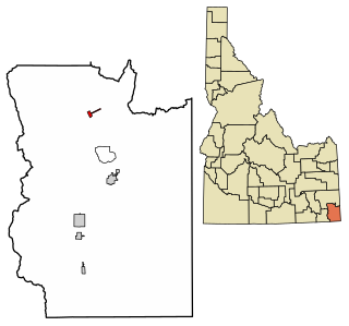
Crouch is a city in Boise County, Idaho, United States. The population was 162 at the 2010 census. It is part of the Boise City–Nampa, Idaho Metropolitan Statistical Area. In 2018, it has multiple commercial businesses for tourists and residents: a small grocery mart, a hardware store, three restaurants, a bar, The Starlight Mountain Theater, and a community thrift store. At that time, the construction of the Banks/Lowman road 2512A, The "Wildlife Canyon Scenic Byway highway, transformed a small unpaved road unto a paved modern road between Crouch and Lowman. Now it is a fully modern paved roadway with informational and white water rafting pull outs which serves to transport tourists, rafters, commuters, and other traffic across the middle Idaho region.

<span class="mw-page-title-main">Clark Fork, Idaho</span> City in Idaho, United States

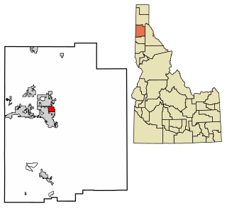
Clark Fork is a small town in Bonner County, Idaho. The population was 536 at the time of the 2010 census.

<span class="mw-page-title-main">Ucon, Idaho</span> City in Idaho, United States

Ucon is a city in Bonneville County, Idaho, United States. It is part of the Idaho Falls, Idaho Metropolitan Statistical Area. The population was 1,108 at the 2010 census. Ucon was first settled in 1883.

<span class="mw-page-title-main">Notus, Idaho</span> City in Idaho, United States

Notus is a small rural city in Canyon County, Idaho. The population was 531 at the time of the 2010 census and is the smallest town out of the eight in Canyon County. It is part of the Boise metropolitan area.

<span class="mw-page-title-main">Wilder, Idaho</span> City in Idaho, United States

Wilder is a city in Canyon County, Idaho, United States. The population was 1,533 at the 2010 census.

<span class="mw-page-title-main">Soda Springs, Idaho</span> City in the United States

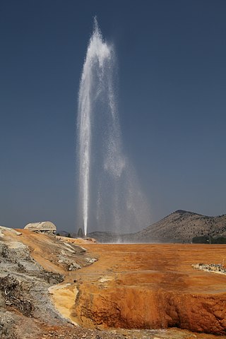
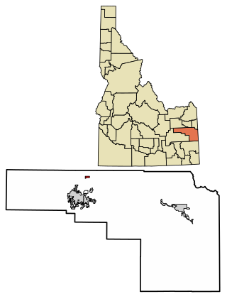
Soda Springs is a city in Caribou County, Idaho, United States. Its population was 3,133 at the time of the 2020 census. The city has been the county seat of Caribou County since the county was organized in 1919. In the 1860s, Soda Springs served as the seat of Oneida County.

<span class="mw-page-title-main">Glenns Ferry, Idaho</span> City in Idaho, United States

Glenns Ferry is a city in Elmore County, Idaho, United States. The population was 1,293 at the 2020 census. The city is adjacent to Interstate 84 and the Snake River.

<span class="mw-page-title-main">Dayton, Idaho</span> City in Idaho, United States

Dayton is a city in Franklin County, Idaho, United States. The population was 463 at the 2010 census. It is part of the Logan, Utah-Idaho Metropolitan Statistical Area.

<span class="mw-page-title-main">Hazelton, Idaho</span> City in Idaho, United States

Hazelton is a city in Jerome County, Idaho, United States. The population was 807 at the 2020 census. It is part of the Twin Falls, Idaho Micropolitan Statistical Area.

<span class="mw-page-title-main">Dalton Gardens, Idaho</span> City in Kootenai County, Idaho, United States

Dalton Gardens is a city in Kootenai County, Idaho, United States. It is considered a suburb of Coeur d'Alene and borders the city to the north and east. The city of Dalton Gardens is also part of the larger Spokane-Coeur d'Alene Combined Metropolitan Statistical Area which encompasses Kootenai County, Idaho. The population of Dalton Gardens was 2,335 at the time of the 2010 census.

<span class="mw-page-title-main">Worley, Idaho</span> City in Idaho, United States

Worley is a city in southwestern Kootenai County, Idaho, United States. The population was 257 at the 2010 census, up from 223 in 2000. The city is within the Coeur d'Alene Indian Reservation.

<span class="mw-page-title-main">Rupert, Idaho</span> City in Idaho, United States

Rupert is the county seat and largest city of Minidoka County, Idaho. It is part of the Burley Micropolitan Statistical Area. The population was 6,082 at the 2020 census, up from 5,554 in 2010.

<span class="mw-page-title-main">Grand View, Idaho</span> City in Owyhee County, Idaho, United States

Grand View is a city along the Snake River in Owyhee County, Idaho, United States. The population was 440 at the 2020 census. It is part of the Boise City–Nampa, Idaho Metropolitan Statistical Area.

<span class="mw-page-title-main">Castleford, Idaho</span> City in Idaho, United States

Castleford is a city in Twin Falls County, Idaho, United States. The population was 226 at the 2010 census. It is part of the Twin Falls, Idaho Micropolitan Statistical Area.

References

  1. "Mayor and City Council". City of Mountain Home. 2011. Archived from the original on April 2, 2012. Retrieved July 8, 2016.
  2. "2019 U.S. Gazetteer Files". United States Census Bureau. Retrieved July 9, 2020.
  3. "Find a County". National Association of Counties. Retrieved June 7, 2011.
  4. 1 2 Rees, John E. (1918). Idaho Chronology, Nomenclature, Bibliography. W.B. Conkey Company. p.  93.
  5. Conley, Cort (1982). Idaho for the Curious. p. 417[ need quotation to verify ]. ISBN   0-9603566-3-0.
  6. "US Gazetteer files: 2010, 2000, and 1990". United States Census Bureau. February 12, 2011. Retrieved April 23, 2011.
  7. "US Gazetteer files 2010". United States Census Bureau. Archived from the original on January 12, 2012. Retrieved December 18, 2012.
  8. "U.S. Climate Normals Quick Access – Station: MTN Home, ID (19912020)". National Oceanic and Atmospheric Administration. Retrieved February 20, 2023.
  9. "U.S. Climate Normals Quick Access – Station: MTN Home, ID (19812010)". National Oceanic and Atmospheric Administration. Retrieved February 20, 2023.
  10. "xmACIS2". National Oceanic and Atmospheric Administration. Retrieved February 20, 2023.
  11. "Decennial Census of Population and Housing". Census.gov. Retrieved May 23, 2022.
  12. "U.S. Census website". United States Census Bureau . Retrieved May 23, 2022.
  13. "U.S. Census website". United States Census Bureau . Retrieved December 18, 2012.
  14. "U.S. Census website". United States Census Bureau . Retrieved January 31, 2008.
  15. "Korey Hall". NFL.com. Retrieved December 1, 2018.
  16. "United States Census, 1920", database with images, FamilySearch, Charlotte Lamberton in entry for Frank S Lamberton, 1920. (https://www.familysearch.org/ark:/61903/1:1:MDCL-FFB)
  17. "Ford Rainey Biography (1908-)". www.filmreference.com. Retrieved December 1, 2018.
  18. "Astronaut Bio: James Reilly (5/2008)". www.jsc.nasa.gov. Retrieved December 1, 2018.
  19. Ryals, Mitch (January 11, 2018). "Victor Wooten, one of the greatest bassists ever, stops in Spokane this weekend". Inlander. Retrieved June 18, 2020. While his wife emptied the dishwasher, the Mountain Home, Idaho-born musician spoke to the Inlander...

Further reading