| Mud Lake | |
|---|---|
 Mud Lake  Mud Lake | |
| Location | Sierra County, New Mexico |
| Coordinates | 33°04′30″N107°45′30″W / 33.07500°N 107.75833°W |
| Basin countries | United States |
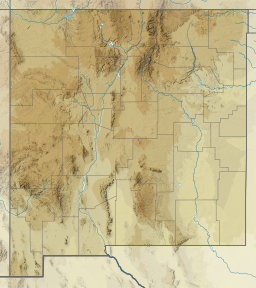
Mud Lake, is a lake located in Sierra County within the U.S. state of New Mexico.
| Mud Lake | |
|---|---|
| Mud Lake Mud Lake | |
| Location | Sierra County, New Mexico |
| Coordinates | 33°04′30″N107°45′30″W / 33.07500°N 107.75833°W |
| Basin countries | United States |
Mud Lake, is a lake located in Sierra County within the U.S. state of New Mexico.

Sibley County is a county in the South Central part of the U.S. state of Minnesota. As of the 2020 census, the population was 14,836. Its county seat is Gaylord. Sibley County was part of the Minneapolis-St. Paul-Bloomington, MN-WI Metropolitan Statistical Area from 2013 to September 2018.

Le Sueur County is a county located in the south central portion of the U.S. state of Minnesota. As of the 2020 census, the population was 28,674. Its county seat is Le Center.

Jefferson County is a county located in the U.S. state of Idaho. As of the 2020 Census, the county's population was 30,891. In the 2010 census, the population was 26,140. The county seat and largest city is Rigby. The county was established in 1913 and named after Thomas Jefferson, the third U.S. President. Jefferson County is part of the Idaho Falls, ID Metropolitan Statistical Area.
Mud Lake is an unorganized territory located in Marshall County, Minnesota, United States. In both the 2000 and 2010 U.S. censuses, the unorganized territory recorded a population of 0.

Mudflats or mud flats, also known as tidal flats or, in Ireland, slob or slobs, are coastal wetlands that form in intertidal areas where sediments have been deposited by tides or rivers. A global analysis published in 2019 suggested that tidal flat ecosystems are as extensive globally as mangroves, covering at least 127,921 km2 (49,391 sq mi) of the Earth's surface. They are found in sheltered areas such as bays, bayous, lagoons, and estuaries; they are also seen in freshwater lakes and salty lakes alike, wherein many rivers and creeks end. Mudflats may be viewed geologically as exposed layers of bay mud, resulting from deposition of estuarine silts, clays and aquatic animal detritus. Most of the sediment within a mudflat is within the intertidal zone, and thus the flat is submerged and exposed approximately twice daily.

Mudrocks are a class of fine-grained siliciclastic sedimentary rocks. The varying types of mudrocks include siltstone, claystone, mudstone, slate, and shale. Most of the particles of which the stone is composed are less than 1⁄16 mm and are too small to study readily in the field. At first sight, the rock types appear quite similar; however, there are important differences in composition and nomenclature.

The New Zealand mud snail is a species of very small freshwater snail with a gill and an operculum. This aquatic gastropod mollusk is in the family Tateidae.
Mud Lake Delta Provincial Park is a provincial park in British Columbia, Canada, located in the North Thompson Country due east of Blue River, 230 km from Kamloops on BC Highway 5.
Carp River is a 40.2-mile-long (64.7 km) river in Chippewa and Mackinac counties in the U.S. state of Michigan. 21.7 miles (34.9 km) of the river were added to the National Wild and Scenic Rivers System in 1992.
Mud Lake is an oxbow lake located in northwestern DeSoto County, Mississippi and in southwestern Shelby County, Tennessee. It was created by changes in the flow of the Mississippi River and borders Horn Lake (Tennessee) to the east. The lake was formerly accessible to the public. However, all surrounding land was purchased by Ensley Bottom Farms LLC thereby eliminating public access. The area has been turned into a private hunting and fishing club depriving many citizens from what was formerly a public lake used by many.

The Pere Marquette River is a river in Michigan in the United States. The main stream of this river is 63.9 miles (102.8 km) long, running from Lake County south of Baldwin into the Pere Marquette Lake, and from there into Lake Michigan.

Wayne Township is one of twelve townships in Buchanan County, Missouri, USA. As of the 2010 census, its population was 683.
Newport Center is the primary village and a census-designated place (CDP) in the town of Newport, Orleans County, Vermont, United States. As of the 2020 census, it had a population of 231, out of 1,526 in the town of Newport.
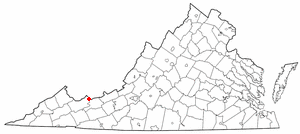
Falls Mills is an unincorporated community and census-designated place along Virginia State Route 102 in Tazewell County, Virginia, United States and is located at the mouth of Mud Fork Valley. It is part of the Bluefield, WV-VA micropolitan area, which has a population of 107,578.
The Little River is a short river in Madawaska, Maine, about 4 miles (6 km) from the Canada–United States border. The river flows west 5.1 miles (8.2 km) from its source to Long Lake. The lake drains — via Mud Lake, Cross Lake, Square Lake, and Eagle Lake — into the Fish River, a tributary of the Saint John River.
The West Branch Mattawamkeag River is a 52.6-mile-long (84.7 km) tributary of the Mattawamkeag River in Maine. From its source in Maine Township 6, Range 6, WELS, the river runs 10 miles (16 km) northeast by Pleasant Lake and through Mud Lake and Rockabema Lake, then 42 miles (68 km) south and southeast through Upper Mattawamkeag Lake and Mattawamkeag Lake to its confluence with the East Branch Mattawamkeag River in Haynesville, about 10 miles (16 km) west of the Canada–United States border.
The equal footing doctrine, also known as equality of the states, is the principle in United States constitutional law that all states admitted to the Union under the Constitution since 1789 enter on equal footing with the 13 states already in the Union at that time. The Constitution grants to Congress the power to admit new states in Article IV, Section 3, Clause 1, which states:
New States may be admitted by the Congress into this Union; but no new State shall be formed or erected within the Jurisdiction of any other State; nor any State be formed by the Junction of two or more States, or Parts of States, without the Consent of the Legislatures of the States concerned as well as of the Congress.

The Salton Trough is an active tectonic pull-apart basin, or graben. It lies within the Imperial, Riverside, and San Diego counties of southeastern California, United States and extends south of the Mexico–United States border into the state of Baja California, Mexico. The northwestern end of the trough starts at the San Gorgonio Pass in Riverside County, and extends 115 miles (185 km) southeast to the Gulf of California. Major geographical features located in the trough include the Coachella Valley, the Salton Sea, and the Imperial Valley, in the United States, and the western side of the Mexicali Valley, and the Colorado River Delta in Mexico.

The Pine River is a 103-mile-long (166 km) river in the Lower Peninsula of the U.S. state of Michigan. The Pine River is a tributary of the Chippewa River and is thus part of the Saginaw River drainage basin.
| | This New Mexico state location article is a stub. You can help Wikipedia by expanding it. |
| | This article related to a lake in the United States is a stub. You can help Wikipedia by expanding it. |