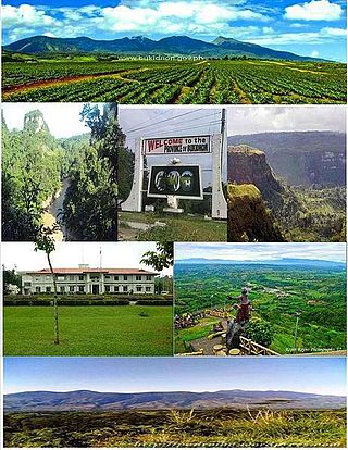
Bukidnon, officially the Province of Bukidnon, is a landlocked province in the Philippines located in the Northern Mindanao region. Its capital is the city of Malaybalay while Valencia is the largest city. The province borders, clockwise from the north, Misamis Oriental, Agusan del Sur, Davao del Norte, Cotabato, Lanao del Sur, and Lanao del Norte. According to the 2020 census, the province is inhabited by 1,541,308 residents. The province is composed of 2 component cities and 20 municipalities. It is the third largest province in the country in terms of total area of jurisdiction behind Palawan and Isabela respectively.

Malaybalay, officially the City of Malaybalay, is a 1st class component city and capital of the province of Bukidnon, Philippines. According to the 2020 census, it has a population of 190,712 people.

The Rio Grande de Mindanao, also known as the Mindanao River, is the second-largest river system in the Philippines. Located on the southern island of Mindanao, with a total drainage area of 23,169 km2 (8,946 sq mi), draining the majority of the central and eastern portion of the island, and a total length of approximately 373 km (232 mi). It is an important transportation artery, used mainly in transporting agricultural products and, formerly, timber.

Valencia, officially the City of Valencia, is a 1st class component city in the province of Bukidnon, Philippines. According to the 2020 census, it has a population of 216,546 people. The city is applying for a Highly Urbanized City (HUC).

Dangcagan, officially the Municipality of Dangcagan, is a 3rd class municipality in the province of Bukidnon, Philippines. According to the 2020 census, it has a population of 26,076 people, making it the least populated municipality in the province.

Impasugong, officially the Municipality of Impasugong, is a 1st class municipality in the province of Bukidnon, Philippines. According to the 2020 census, it has a population of 53,863 people.

Kibawe, officially the Municipality of Kibawe, is a 2nd class municipality in the province of Bukidnon, Philippines. According to the 2020 census, it has a population of 41,897 people.

Kitaotao, officially the Municipality of Kitaotao, is a 1st class municipality in the province of Bukidnon, Philippines. According to the 2020 census, it has a population of 53,796 people.
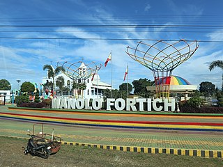
Manolo Fortich, officially the Municipality of Manolo Fortich, is a 1st class municipality in the province of Bukidnon, Philippines. According to the 2020 census, it has a population of 113,200 people.
Maramag, officially the Municipality of Maramag, is a 1st class municipality in the province of Bukidnon, Philippines. According to the 2020 census, it has a population of 108,293 people.

Musuan Peak or Mount Musuan, also known as Mount Calayo is an active volcano in Maramag, Bukidnon, on the island of Mindanao in the Philippines. It is 4.5 kilometres (2.8 mi) south of the city of Valencia, province of Bukidnon, and 81 kilometres (50 mi) southeast of Cagayan de Oro.
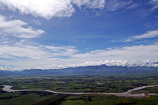
The Pulangi River ;, also spelled Pulangui, is one of the major tributaries of the Rio Grande de Mindanao, an extensive river system in Mindanao, Philippines. With a length of 320 kilometres (199 mi), it is the longest river in Bukidnon and the 5th longest river in the Philippines. It traverses through majority of the cities and municipalities of Bukidnon from its source in Barangay Kalabugao, Impasugong, Bukidnon.
The Kalatungan Mountain Range in the central portion of the province of Bukidnon, Philippines, is one of the few areas in the province covered with old growth or mossy forests. It covers an area of approximately 213.0134 km2 (82.24493 mi2), with about 113.7175 km2 (43.90657 mi2) identified as part of the critical watershed area declared under Presidential Decree 127, issued on June 29, 1987. The water from two rivers, the Muleta and Manupali Rivers, flood the multimillion dam project of the Philippine National Irrigation Administration (NIA). The rivers drain into the Pulangi River, the site of a National Power Corporation hydroelectric dam.

The Kitanglad Mountain Range dominates the northern central portion of the province of Bukidnon, Philippines. It occupies portions of eight of the municipalities and cities in the province such as Talakag, Baungon, Libona, Manolo Fortich, Impasugong, Lantapan and Malaybalay. The range is one of the few remaining rainforests in the Philippines, hosting one of the most important diverse species of rare and endemic wildlife such as the Philippine eagle. Five of its peaks have very high elevations: Mount Dulang-dulang, the highest at 2,941 m (9,649 ft); Mount Kitanglad at 2,899 meters; Mount Maagnaw at 2,742 meters; Mount Lumuluyaw at 2,612 meters; and Mount Tuminungan at 2,400 meters.

Mount Dulang-dulang, dubbed by Filipino mountaineers as "D2" and also known as Mount Katanglad, is the highest elevation peak in the Kitanglad Mountain Range, located in the north central portion of the province of Bukidnon in the island of Mindanao. It is the second highest mountain of the Philippines at 2,941 metres (9,649 ft) above sea level, second only to Mount Apo of Davao at 2,956 m (9,698 ft) and slightly higher than Mount Pulag of Luzon, the third highest at 2,928 m (9,606 ft).
The Manupali River is a river in central Bukidnon, on the Philippine island of Mindanao. It is one of the major tributaries of the Pulangi River that drains into the Rio Grande de Mindanao. Among its tributaries are Balangbangan Creek and the Maagnao and Tandacol Rivers.
The Sawaga River is a river in Central Bukidnon, Philippines on the island of Mindanao. A majority of its catchment area is located in Malaybalay City. Its source is from a watershed west of Mt. Tuminungan in Barangay Dalwangan. It flows shortly northward and then eastward into Patpat and Kalasungay, the river then flows southward into the Poblacion District, past Casisang, San Jose, and Laguitas. The Lower Sawaga Valley is located in its lower course from Barangay Linabo through Bangcud until it meets with the Manupali River and ends at Pulangi River in Kahaponan, Valencia City. The Sawaga River has a total length of about 64.5 km and the basin has a total of 42,692 hectares.
The Maradugao River is a river that serves as a natural boundary between the provinces of Bukidnon and Lanao del Sur in Mindanao in southern Philippines. It joins the Pulangi River in Cotabato.
Busdi is a rural barangay of the Upper Pulangi District of Malaybalay, Bukidnon, Philippines. According to the 2015 census, it has a population of 2,377 people. It is bounded to the north by Barangay Bulonay of Impasug-ong, to the east by the Municipality of La Paz, Agusan del Sur, to the south by Saint Peter and Kulaman, and to the west by Kibalabag and Manalog.

