| Murton | |
|---|---|
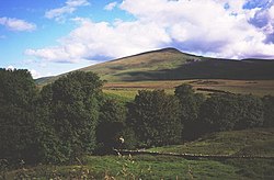 Murton Pike | |
 Murton Location within Cumbria | |
| Population | 360 (2011) [1] |
| OS grid reference | NY7221 |
| Civil parish |
|
| Unitary authority | |
| Ceremonial county | |
| Region | |
| Country | England |
| Sovereign state | United Kingdom |
| Post town | APPLEBY IN WESTMORLAND |
| Postcode district | CA16 |
| Dialling code | 01768 |
| Police | Cumbria |
| Fire | Cumbria |
| Ambulance | North West |
| UK Parliament | |
Murton is a small village and civil parish in Westmorland and Furness, Cumbria, England. The parish had a population of 330 in 2001, [2] rising to 360 at the 2011 Census. [1] Settlements within the parish include the villages of Hilton, Langton, and Brackenber as well as various small farms, houses and cottages. The town of Appleby-in-Westmorland is to the south-west.