


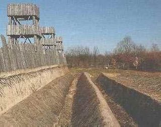
Murus gallicus or Gallic wall is a method of construction of defensive walls used to protect Iron Age hillforts and oppida of the La Tene period in Western Europe.
Murus gallicus or Gallic wall is a method of construction of defensive walls used to protect Iron Age hillforts and oppida of the La Tene period in Western Europe.
The distinctive features are:
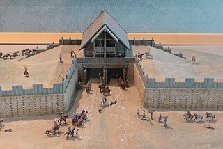
The technique of construction and the utility of the walls was described by Julius Caesar in his Commentaries on the Gallic War :
But this is usually the form of all the Gallic walls. Straight beams, connected lengthwise and two feet distant from each other at equal intervals, are placed together on the ground; these are morticed on the inside, and covered with plenty of earth. But the intervals which we have mentioned, are closed up in front by large stones. These being thus laid and cemented together, another row is added above, in such a manner, that the same interval may be observed, and that the beams may not touch one another, but equal spaces intervening, each row of beams is kept firmly in its place by a row of stones. In this manner the whole wall is consolidated, until the regular height of the wall be completed. This work, with respect to appearance and variety, is not unsightly, owing to the alternate rows of beams and stones, which preserve their order in right lines; and, besides, it possesses great advantages as regards utility and the defense of cities; for the stone protects it from fire, and the wood from the battering ram, since it [the wood] being mortised in the inside with rows of beams, generally forty feet each in length, can neither be broken through nor torn asunder. [1]
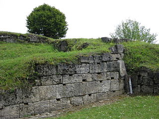
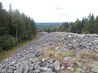
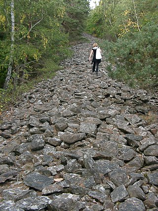
About 30 structures of this type have been excavated, mainly in Gaul, but extending to the upper reaches of the Rhine and Danube. The example at the sea promontory fort of Le Camp d'Artus, at Huelgoat, was excavated and reported by Mortimer Wheeler.
At Manching an earlier murus gallicus wall was rebuilt in the pfostenschlitzmauer style.
The murus gallicus contrasts with other construction styles:

This article concerns the period 59 BC – 50 BC.

A hillfort is a type of earthwork used as a fortified refuge or defended settlement, located to exploit a rise in elevation for defensive advantage. They are typically European and of the Bronze Age or Iron Age. Some were used in the post-Roman period. The fortification usually follows the contours of a hill and consists of one or more lines of earthworks, with stockades or defensive walls, and external ditches.
The Battle of Alesia or Siege of Alesia was the climactic military engagement of the Gallic Wars, fought around the Gallic oppidum of Alesia in modern France, a major centre of the Mandubii tribe. It was fought by the Roman army of Julius Caesar against a confederation of Gallic tribes united under the leadership of Vercingetorix of the Arverni. It was the last major engagement between Gauls and Romans, and is considered one of Caesar's greatest military achievements and a classic example of siege warfare and investment; the Roman army built dual lines of fortifications – an inner wall to keep the besieged Gauls in, and an outer wall to keep the Gallic relief force out. The Battle of Alesia marked the end of Gallic independence in the modern day territory of France and Belgium.

Lutetia, also known as Lutetia Parisiorum, was a Gallo–Roman town and the predecessor of modern-day Paris. Traces of an earlier Neolithic settlement have been found nearby, and a larger settlement was established around the middle of the third century BC by the Parisii, a Gallic tribe. The site was an important crossing point of the Seine, the intersection of land and water trade routes.
An oppidum is a large fortified Iron Age settlement or town. Oppida are primarily associated with the Celtic late La Tène culture, emerging during the 2nd and 1st centuries BC, spread across Europe, stretching from Britain and Iberia in the west to the edge of the Hungarian plain in the east. These settlements continued to be used until the Romans conquered Southern and Western Europe. Many subsequently became Roman-era towns and cities, whilst others were abandoned. In regions north of the rivers Danube and Rhine, such as most of Germania, where the populations remained independent from Rome, oppida continued to be used into the 1st century AD.

Bibracte, a Gallic oppidum, was the capital of the Aedui and one of the most important hillforts in Gaul. It was located near modern Autun in Burgundy, France. The material culture of the Aedui corresponded to the Late Iron Age La Tène culture.

Avaricum was an oppidum in ancient Gaul, near what is now the city of Bourges. Avaricum, situated in the lands of the Bituriges Cubi, was the largest and best-fortified town within their territory, situated on very fertile lands. The terrain favored the oppidum, as it was flanked by a river and marshland, with only a single narrow entrance. By the time of the Roman conquest in 52 BC the city according to Julius Caesar had a population of 40,000 people who were then almost all killed.

The Oppidum of Manching was a large Celtic proto-urban or city-like settlement at modern-day Manching, near Ingolstadt, in Bavaria, Germany. The Iron Age town was founded in the 3rd century BC and existed until c. 50-30 BC. It reached its largest extent during the late La Tène period, when it had a size of 380 hectares. At that time, 5,000 to 10,000 people lived within its 7.2 km walls. Thus, the Manching oppidum was one of the largest settlements north of the Alps. The ancient name of the site is unknown, but it is assumed that it was the central site of the Celtic Vindelici tribe.
Murus Dacicus is a construction method for defensive walls and fortifications developed in ancient Dacia sometime before the Roman conquest. It is a mix between traditional construction methods particular to Dacian builders and methods imported from Greek and Roman architecture and masonry, and – although somewhat similar construction techniques were used before, during and long after the period – it has peculiarities that make it unique.

Alesia was the capital of the Mandubii, one of the Gallic tribes allied with the Aedui. The Celtic oppidum was conquered by Julius Caesar during the Gallic Wars and afterwards became a Gallo-Roman town. Modern understanding of its location was controversial for a long time; however, it is now thought to have been located on Mont-Auxois, near Alise-Sainte-Reine in Burgundy, France.

Caesar's bridges across the Rhine, the first two bridges on record to cross the Rhine river, were built by Julius Caesar and his legionaries during the Gallic War in 55 BC and 53 BC. Strategically successful, they are also considered masterpieces of military engineering.

A Pfostenschlitzmauer is the name for defensive walls protecting Bronze Age and Iron Age hill forts and oppida in Central Europe, especially in Bavaria and the Czech Republic. They are characterized by vertical wooden posts set into the front stone facing. The rampart is constructed from a timber lattice filled with earth or rubble. The transverse cross-beams may also protrude through the stone facing, as with the murus gallicus used in Gaul and western Germany. It is sometimes referred to in English as a timber-framed wall.
The Celtic hill fort of Otzenhausen is one of the biggest fortifications the Celts ever constructed. It was built by Gauls of the Treveri tribe, who lived in the region north of the fort. The fort is located on top of the Dollberg, a hill near Otzenhausen in Germany, about 695 m above sea level. The only visible remains are two circular earth ramparts, covered with stones.

Buckland Rings is the site of an Iron Age hill fort in the town of Lymington, Hampshire. Today, the mounds and dykes around the outside which once constituted its defences are still clearly visible, although the outer bank lies under the road on the west side, and on the south-east it is nearly ploughed-out. Excavations of the inner and middle ramparts in 1935 revealed that they were of wall-and-fill construction, retained at the front by upright timber beams and walls of cut and laid turf. The entrance, which lies on the east side, was also excavated revealing a long entrance passage and the postholes for a pair of stout gateposts. The site was bought by Hampshire County Council in 1989 to ensure its preservation, and it is open to the public from the A337 road onto which part of it faces.
Hillforts in Britain refers to the various hillforts within the island of Great Britain. Although the earliest such constructs fitting this description come from the Neolithic British Isles, with a few also dating to later Bronze Age Britain, British hillforts were primarily constructed during the British Iron Age. Some of these were apparently abandoned in the southern areas that were a part of Roman Britain, although at the same time, those areas of northern Britain that remained free from Roman occupation saw an increase in their construction. Some hillforts were reused in the Early Middle Ages, and in some rarer cases, into the Later Medieval period as well. By the early modern period, these had essentially all been abandoned, with many being excavated by archaeologists in the nineteenth century onward.

Mont-Terri Castle is a ruined medieval castle above a prehistoric hillfort on Mont Terri, located in the municipality of Cornol of the Canton of Jura in Switzerland. It is a Swiss heritage site of national significance.
The Heidenmauer near the Palatine county town of Bad Dürkheim in the German state of Rhineland-Palatinate is a circular rampart or ringwork, two and a half kilometres long, which was built by the Celts around 500 B. C. as a type of Murus Gallicus but was pulled down again not long afterwards. The wooden elements of the wall have disappeared over the course of time by rotting away, but the stones have survived.

In fortification architecture, a bank or rampart is a length of embankment or wall forming part of the defensive boundary of a castle, hillfort, settlement or other fortified site. It is usually broad-topped and made of excavated earth and/or masonry.

Burghead Fort was a Pictish promontory fort on the site now occupied by the small town of Burghead in Moray, Scotland. It was one of the earliest power centres of the Picts and was three times the size of any other enclosed site in Early Medieval Scotland. The fort was probably the main centre of the Pictish Kingdom of Fortriu, flourishing like the kingdom itself from the 4th to the 9th centuries.
Murus Gallicus is an abstract strategy game created in 2009 by Phil Leduc. The name Murus Gallicus is a reference to the stone walls used in the Gallic wars that took place in Gaul, now modern day France. The game has two win conditions that mimic Julius Caesar's strategy of surrounding the gauls. The first is breakthrough, reaching the other side of the board, and the second, stalemate, putting the opponent in a position where they cannot make a legal move.
| Authority control: National |
|---|