
The District Council of Yankalilla is a local government area centred on the town of Yankalilla on the Fleurieu Peninsula in South Australia.
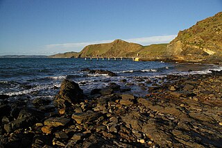
Second Valley is a coastal town on the Fleurieu Peninsula in South Australia.
Carrickalinga is a small coastal town in South Australia about 60 kilometres (37 mi) south of Adelaide on the Fleurieu Peninsula overlooking Gulf St Vincent. The town has no shops, with the nearest being in Normanville, one kilometre away. Haycock Point separates two beaches, sometimes referred to as North Carrickalinga and South Carrickalinga beaches, both on Yankalilla Bay. Carrickalinga Creek discharges into the sea south of the town.

Sellicks Beach, formerly spelt Sellick's Beach, is a suburb in the Australian state of South Australia located within Adelaide metropolitan area about 47 kilometres (29 mi) from the Adelaide city centre. It is an outer southern suburb of Adelaide and is located in the local government area of the City of Onkaparinga at the southern boundary of the metropolitan area. It is known as Witawali or Witawodli by the Traditional Owners, the Kaurna people, and is of significance as being the site of a freshwater spring said to be created by the tears of Tjilbruke, the creator being.
Yankalilla is an agriculturally based town situated on the Fleurieu Peninsula in South Australia, located 72 km south of the state's capital of Adelaide. The town is nestled in the Bungala River valley, overlooked by the southern Mount Lofty Ranges and acts as a service centre for the surrounding agricultural district.

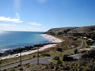
Aldinga Beach is an outer southern suburb of Adelaide, South Australia. It lies within the City of Onkaparinga and has the postcode 5173. At the 2016 census, Aldinga Beach had a population of 10,557. It lies about a kilometre west of the smaller suburb of Aldinga. The beach is a well-known spot for surfing, swimming, scuba diving, and snorkelling during the summer months. It overlooks an aquatic reserve which has been created to safeguard a unique reef formation.

Sellicks Hill – formerly spelt Sellick's Hill – is a semi-rural suburb of Adelaide, South Australia. It lies within both the City of Onkaparinga and the District Council of Yankalilla. Before the British colonisation of South Australia, the Sellicks Hill area, was inhabited by the Kaurna people. Sellick's Hill Post Office opened on 2 July 1860.
Mount Compass is a town and locality in the Australian state of South Australia located in the Mount Lofty Ranges, on the A13 south of Adelaide, and north of Victor Harbor. It is a small community, traditionally supported by farming. Both market gardens and dairy have proved lucrative in the area. At the 2016 census, Mount Compass shared a population of 1,457 with adjoining localities.
Delamere is a locality in the Australian state of South Australia located on the south coast of the Fleurieu Peninsula about 80 kilometres (50 mi) south of the state capital of Adelaide and about 18 kilometres (11 mi) south-west of the municipal seat of Yankalilla. It includes what was once a neighbouring village of Bullaparinga.
De Mole River is a locality in the Australian state of South Australia located on the north coast of Kangaroo Island overlooking Investigator Strait about 175 kilometres south-west of the state capital of Adelaide.
American Beach is a locality in South Australia on the north coast of Dudley Peninsula on Kangaroo Island overlooking Nepean Bay, about 115 kilometres south-west of Adelaide.
Middle River is a locality in the Australian state of South Australia located on the north coast of Kangaroo Island overlooking Investigator Strait about 162 kilometres south-west of the state capital of Adelaide.
Stokes Bay is a locality in the Australian state of South Australia located on the north coast of Kangaroo Island overlooking Investigator Strait about 162 kilometres south-west of the state capital of Adelaide. Its boundaries were created in March 2002 for the “long established name” and includes the Stokes Bay Shack Site. Land use in the locality is principally for agricultural purposes with activity limited on the coastline to the north for conservation purposes. A settlement also occupies land immediately adjoining the bay of the same name. Stokes Bay is located within the federal division of Mayo, the state electoral district of Mawson and the local government area of the Kangaroo Island Council.
Cuttlefish Bay is a locality in the Australian state of South Australia located on the north coast of Dudley Peninsula on Kangaroo Island overlooking Backstairs Passage about 106 kilometres south of the state capital of Adelaide and about 8 kilometres east of Penneshaw. Its boundaries were created in March 2002 while its name was derived from Cuttlefish Bay, a bay located on its coastline with Backstairs Passage. Land use within the locality is concerned with agriculture while land adjoining the coastline has additional statutory constraints to “conserve the natural features of the coast.” Cuttlefish Bay is located within the federal division of Mayo, the state electoral district of Mawson and the local government area of the Kangaroo Island Council.

Myponga Beach is a locality in the Australian state of South Australia about 54 kilometres south of the state capital of Adelaide. It is on the eastern shore of Gulf St Vincent, immediately north of the northern boundary of the Fleurieu Peninsula.
Deep Creek is a locality in the Australian state of South Australia located on the south coast of the Fleurieu Peninsula overlooking Backstairs Passage about 85 kilometres south of the Adelaide city centre.
Tunkalilla is a locality in the Australian state of South Australia located on the south coast of the Fleurieu Peninsula overlooking Backstairs Passage about 83 kilometres south of the state capital of Adelaide.
Muston is a locality in the Australian state of South Australia located on Kangaroo Island overlooking the coastal lagoon known as Pelican Lagoon about 127 kilometres south-west of the state capital of Adelaide and about 21 kilometres south-east of the municipal seat of Kingscote.
Duncan is a locality in the Australian state of South Australia located on Kangaroo Island about 162 kilometres south-west of the state capital of Adelaide and about 49 kilometres west of the municipal seat of Kingscote.
Parawa is a locality in the Australian state of South Australia located about 74 kilometres (46 mi) south of the state capital of Adelaide and about 11 kilometres (6.8 mi) south of the municipal seat in Yankalilla.

