
Bowfell is a pyramid-shaped mountain lying at the heart of the English Lake District, in the Southern Fells area. It is the sixth-highest mountain in the Lake District and one of the most popular of the Lake District fells for walkers. It is listed in Alfred Wainwright's 'best half dozen' Lake District fells.

Fairfield is a fell in the English Lake District. It is the highest of a group of hills in the Eastern Fells, standing to the south of the Helvellyn range.

Dollywaggon Pike is a fell in the English Lake District. It stands on the main spine of the Helvellyn range in the Eastern Fells, between Thirlmere and the Ullswater catchment.

Pike of Blisco, or Pike o' Blisco, is a mountain in the Lake District in Cumbria, England. Located between the valleys of Great Langdale and Little Langdale, its relative isolation from neighbouring fells together with slopes falling away immediately from the summit in all directions mean it has excellent views: the view of the Langdale Pikes across Great Langdale is particularly arresting.

Causey Pike is a fell in the English Lake District. It is situated in the Newlands Valley, 5 kilometres south-west of the town of Keswick. Even though it has a modest height of 637 metres (2,090 ft) it is one of the most distinctive fells when viewed from the Derwent Water and Keswick area due to its distinguishing summit "knobble" which catches the eye. The fell is one of 214 fells described by Alfred Wainwright in his series of Pictorial Guides to the Lakeland Fells: Causey Pike features in Book Six, The North Western Fells.

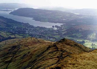
Loughrigg Fell is a hill in the central part of the English Lake District. It stands on the end of the long ridge coming down from High Raise over Silver How towards Ambleside, and is separated from its neighbours by the depression of Red Bank.
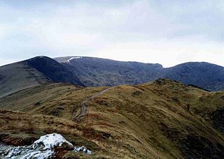
Fairfield Horseshoe is a classic circular hillwalking ridge walk route starting from Rydal or Ambleside in the English Lake District that takes in all the fells that surround the valley of the Rydal Beck.

Dow Crag is a fell in the English Lake District near Coniston, Cumbria. The eastern face is one of the many rock faces in the Lake District used for rock climbing.

Scoat Fell is a fell in the western part of the English Lake District. It stands at the head of the Mosedale Horseshoe with its back to Ennerdale. Paths lead to Scoat Fell from Ennerdale over Steeple, from Wasdale over Red Pike, and along the ridge from Pillar.

Dove Crag is a fell in the English Lake District. Situated in the Eastern Fells of the national park, seven kilometres south-south-west of Glenridding, it reaches a height of 792 metres. The fell is often climbed as part of the Fairfield horseshoe walk but a direct ascent from Patterdale is required to show the fell's full potential, displaying the impressive crags just to the north east of the summit. The highest point was originally unnamed on maps, being just a minor top, but over the years the summit has adopted the name of Dove Crag by mutual accord..
Low Pike is a small fell in the English Lake District. It has a modest height of 508 m (1,667 ft) and is situated three kilometres north of Ambleside. Low Pike is well seen from the streets of the town as the first prominent fell on the ridge which continues northwards for a further four kilometres to Fairfield. This ridge is part of the Fairfield horseshoe walk and Low Pike is most commonly ascended as part of this.

Heron Pike is a fell in the English Lake District, two kilometres east of Grasmere. It is part of the Fairfield group in the Eastern Fells. It should not be confused with the Heron Pike that forms part of Sheffield Pike, although it appears that, by coincidence, both Heron Pikes are exactly the same height.

Great Rigg is a fell in the English Lake District, 7 kilometres north-west of Ambleside and reaching a height of 766 metres. It is most often climbed as part of the Fairfield horseshoe, a 16-km circular walk which starts and finishes in Ambleside. The fell's name originates from the Old English "Rigg", meaning a bumpy or knobbly ridge.

Hart Crag is a fell in the English Lake District, being one of the Fairfield group of hills in the Eastern Fells.

Wetherlam is a mountain in the English Lake District. It is the most northerly of the Coniston Fells, the range of fells to the north-west of Coniston village; its north-east slopes descend to Little Langdale.
Stone Arthur is a fell in the English Lake District, an outlier of the Fairfield group in the Eastern Fells. It stands above Grasmere village.
Brim Fell is a fell in the English Lake District. It stands to the west of Coniston village in the southern part of the District.

The Eastern Fells are a part of the Cumbrian Mountains in the Lake District of England. Centred on Helvellyn they primarily comprise a north–south ridge running between Ullswater and Lakeland's Central Valley.

The North Western Fells are a part of the Cumbrian Mountains in the Lake District of England. Including such favourites as Catbells and Grisedale Pike, they occupy an oval area beneath the Buttermere and Borrowdale valley systems. The North Western Fells are characterised by soaring east-west ridges and an absence of mountain tarns.

