Raise (Lake District)

Last updated

Raise
Raise in the Lake District (geograph 5648109).jpg
Highest point
Elevation 883 m (2,897 ft)
Prominence c. 88 m
Parent peak Helvellyn
Listing Hewitt, Wainwright, Nuttall
Coordinates 54°32′49″N3°00′50″W / 54.547°N 3.014°W / 54.547; -3.014
Geography
Lake District National Park UK relief location map.png
Red triangle with thick white border.svg
Raise
Location in Lake District, UK
Location Cumbria, England
Parent range Lake District, Eastern Fells
OS grid NY342174
Topo map OS Landranger 90

Raise is a fell in the English Lake District. It stands on the main spine of the Helvellyn range in the Eastern Fells, between Thirlmere and Ullswater.

Contents

Topography

The Helvellyn range runs broadly north–south for about 7 miles (11 km), remaining above 2,000 feet (610 m) its entire length. Raise is near the centre of this ridge, with Stybarrow Dodd to the north and White Side to the south. As with many of these fells, Raise displays smooth grassy slopes on the west and rougher ground to the east. Here however the contrast is much less marked than further south around Helvellyn and Nethermost Pike.

Map showing Raise and surrounding features from 1925. Raise Map.jpg
Map showing Raise and surrounding features from 1925.

Unusually for such a high fell, the slopes of Raise do not have a toehold at valley level on either side. In the west the boundary streams of Sticks Gill (West) and Brund Gill meet just below White Side's Brown Crag. As Fisherplace Gill they descend a further thousand feet to the valley, and originally turned north to join St John's Beck. All of this changed as part of the Thirlmere reservoir scheme in 1894, when a water race was constructed to carry most of the water into the lake. To the east the fell is also squeezed out at height by its neighbours, failing to reach the shore of Ullswater. Raise has a short eastern ridge, Stang, descending between Sticks Gill (East) and Glenridding Beck, but these streams combine above the site of the old Greenside Mine to leave Sheffield Pike and Birkhouse Moor overlooking Glenridding.

To the north of Raise the pedestrian route of Sticks Pass crosses the ridge at a height of 2,445 feet (745 m), this being the highest pass in the District crossed by a regular bridleway. [1] Now of use purely to hillwalkers, it once provided the only connection between the communities on either side of the Helvellyns. The name is believed to be taken from the guideposts originally used to mark the route. [2] The becks flowing from either side of the pass summit are both officially named Sticks Gill, the '(East)' and '(West)' having been added by Alfred Wainwright in his Pictorial Guide to the Lakeland Fells and utilised by later guidebook writers. To the north, beyond the pass, the ground rises again to Stybarrow Dodd and all here is grass.

Mining history

South of Raise the ridge swings a little to the west, crossing an unnamed col on the way to White Side. The eastern face of this ridge is gouged deeply by Kepple Cove, a corrie whose back wall is named Red Screes. Kepple Cove once contained an artificial tarn, although today the bed is merely marshy except after heavy rain. The water from the tarn was used in a hydroelectric scheme to drive electric winding gear at Greenside Mine. Commissioned in 1891, this was the first such system in the country. [3] It continued in use until the night of 29 October 1927 when the Kepple Cove dam burst during a heavy storm, leaving an 80 ft (24 m) wide gap in the earthworks. The resulting wave passed down the valley and through Glenridding village, flooding buildings and causing extensive damage. The breached dam can still be seen today. [3] [4]

A further tarn serving Greenside Mine was created in Sticks Gill (East) by the construction of a stone barrage. Called Top Dam, this was still in existence in the 1950s but is now a dry bed. There are other signs of mining activity on the Stang ridge, in particular the stone smelter flue. Prominently marked 'chimney' on Ordnance Survey maps, the flue ran over half a mile up the fellside to a stone chimney at about 2,250 ft (690 m). There are also the remains of a number of leats, artificial channels to divert streams to the thirsty mine. Stang now carries the marks of a more modern industry, with the Lake District's only permanent ski-tow installed on the northern slope. There is some rock outcropping on the eastern slopes of Raise, particularly at Stang End above the Glenridding Beck.

Geology

Geologically, the summit of Raise is part of the Birker Fell Formation of plagioclase-phyric andesite lava, with pyroclastic breccia to the south west. There are also substantial areas of gravel drift. [5]

Summit

Alone among the northern Helvellyns, Raise has a summit area of outcropping rock, an island amid the sea of grass. A little to the east of the top is a rock tor which would be insignificant elsewhere, but in these surroundings draws the eye. A path follows the ridge, with a surfeit of cairns to the south. [1] The view is extensive with all of the major fells being seen. Thirlmere can also be brought into view by walking a few yards to the west. [2]

Ascents

The main routes of ascent are via Sticks Pass, starting from either Legburthwaite or Glenridding. More direct climbs from the west can be made by following Fisherplace Gill and then striking up across the pathless prairie as required. From the east there is a path rising directly up the Stang ridge and a further old route zig-zags up from Glenridding Beck beside Kepple Cove.

Ski Club

The Lake District Ski Club, operate a Poma-style ski lift from pylons on Raise when weather conditions are suitable for skiing or snowboarding. The lift is some 360 m (1,180 ft) long, and the runs are in a natural snow bowl called Savages Gulley where snow drifts form. The Lake District Ski Club had operated for 75 years by 2011, and recently expanded their facilities to include the "Powder room" lavatory facilities attached to the engine hut. [6]

Related Research Articles

<span class="mw-page-title-main">Helvellyn</span> Mountain in the English Lake District

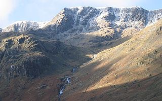
Helvellyn is a mountain in the English Lake District, the highest point of the Helvellyn range, a north–south line of mountains to the north of Ambleside, between the lakes of Thirlmere and Ullswater.

<span class="mw-page-title-main">Fairfield (Lake District)</span> Fell in the English Lake District

Fairfield is a fell in the English Lake District. It is the highest of a group of hills in the Eastern Fells, standing to the south of the Helvellyn range.

Catstye Cam is a fell in the English Lake District. It is an outlier of Helvellyn in the Eastern Fells.

<span class="mw-page-title-main">Great Dodd</span> Mountain in the English Lake District, Cumbria, England

Great Dodd is a mountain or fell in the English Lake District. It stands on the main ridge of the Helvellyn range, a line of mountains which runs in a north-south direction between the lakes of Thirlmere and Ullswater in the east of the Lake District. Great Dodd, with a height of 857 m is the highest of the fells in this range to the north of Sticks Pass.

<span class="mw-page-title-main">Place Fell</span> Fell in the Lake District, Cumbria, England

Place Fell is a hill in the English Lake District. It stands at the corner of the upper and middle reaches of Ullswater, with steep western flanks overlooking the villages of Glenridding and Patterdale.

<span class="mw-page-title-main">Nethermost Pike</span> Fell in Cumbria, England

Nethermost Pike is a fell in Cumbria, England, and a part of the Lake District. At 891 metres (2,923 ft) it is the second highest Wainwright in the Helvellyn range, the highest of which is Helvellyn itself. It is located close to the southern end of the ridge, with Helvellyn to the north, and High Crag and Dollywaggon Pike to the south. Nethermost Pike, along with many of the Eastern Fells, lies between Thirlmere in the west and the Ullswater catchment in the east. The closest villages are Glenridding and Patterdale on the shores of Ullswater, over 8 kilometres (5 mi) away.

<span class="mw-page-title-main">White Side</span> Fell in the Lake District, Cumbria, England

White Side is a fell in the English Lake District. It is situated to the east of Thirlmere and to the west of Glenridding valley. This places White Side in the Helvellyn range of the Eastern Fells, with Raise to the north and Helvellyn Lower Man to the south, both of which are of greater height.

<span class="mw-page-title-main">Dollywaggon Pike</span> Mountain in the English Lake District, Cumbria, England

Dollywaggon Pike is a fell in the English Lake District. It stands on the main spine of the Helvellyn range in the Eastern Fells, between Thirlmere and the Ullswater catchment.

<span class="mw-page-title-main">Stybarrow Dodd</span> Fell in the Lake District, Cumbria, England

Stybarrow Dodd is a mountain or fell in the English Lake District. It stands immediately north of Sticks Pass on the main ridge of the Helvellyn range in the Eastern Fells, which is situated between the lakes of Thirlmere and the Ullswater.

<span class="mw-page-title-main">Red Tarn</span> A mountain lake in Cumbria, England

Red Tarn is a small lake in the eastern region of the English Lake District, in the county of Cumbria. It is high up on the eastern flank of Helvellyn, beneath Striding Edge and Catstye Cam. Red Tarn was formed when the glacier that carved out the eastern side of Helvellyn had melted. The lake along with three others in Lake District is a habitat for the very rare and endangered Schelly fish. Red Tarn was a dam in the nineteenth century that used boulders that raised the water level some eight or nine feet in order to supply power to the Greenside Mine at Glenridding. Today the tarn is a popular rest stop for hikers and nature goers.

<span class="mw-page-title-main">Glenridding</span> Human settlement in England

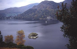
Glenridding is a village at the southern end of Ullswater, in the English Lake District. The village is popular with mountain walkers who can scale England's third-highest mountain, Helvellyn, and many other challenging peaks from there.

<span class="mw-page-title-main">Ullscarf</span> Fell in England

Ullscarf is a fell in the English Lake District close to the geographical centre of the Cumbrian hills. It forms part of the watershed between the Derwentwater and Thirlmere catchments, a ridge running broadly north-south.

<span class="mw-page-title-main">Seat Sandal</span> Fell in the Lake District, Cumbria, England

Seat Sandal is a fell in the English Lake District, situated four kilometres north of the village of Grasmere from where it is very well seen. Nevertheless, it tends to be overshadowed by its more illustrious neighbours in the Eastern Fells, Helvellyn and Fairfield.

<span class="mw-page-title-main">Watson's Dodd</span>

Watson's Dodd is a fell in the English Lake District, a minor rise on the main ridge of the Helvellyn range in the Eastern Fells, but a prominent shoulder on the west side of that range.

<span class="mw-page-title-main">Hart Side</span>

Hart Side is a subsidiary top on one of the east ridges of Stybarrow Dodd, which is a mountain in the English Lake District, west of Ullswater on the main Helvellyn ridge in the Eastern Fells. With a height of 2,480 feet (760 m) Hart Side rises above the col separating it from Green Side by 75 feet (23 m).

<span class="mw-page-title-main">Birkhouse Moor</span>

Birkhouse Moor is a fell in the English Lake District, an outlier of the Helvellyn range in the Eastern Fells. It is properly an eastern ridge of Helvellyn, but was treated as a separate fell by Alfred Wainwright in his Pictorial Guide to the Lakeland Fells. That convention is followed here.

<span class="mw-page-title-main">Sheffield Pike</span>

Sheffield Pike is a fell in the English Lake District, a prominent intermediate top on one of the eastern ridges of Stybarrow Dodd. It separates and stands high above the Glencoyne and Glenridding valleys, on the eastern side of the Helvellyn range in the Eastern Fells and it looks down onto Ullswater.

<span class="mw-page-title-main">Middle Dodd</span>

Middle Dodd is a fell in the English Lake District, an outlier of the Helvellyn range in the Eastern Fells. It stands above Kirkstone Pass on the road from Ullswater to Ambleside.

<span class="mw-page-title-main">Glenridding Dodd</span>

Glenridding Dodd is a small fell in the English Lake District, at the end of a ridge descending from the Helvellyn range in the Eastern Fells. It stands above the village of Glenridding and on the western shore of Ullswater. Although small and not of great elevation, its top is a fine viewpoint for Ullswater and for the fells clustered round the valleys above Patterdale.

<span class="mw-page-title-main">Eastern Fells</span>

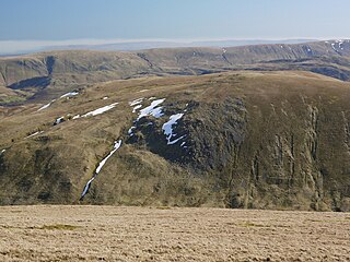
The Eastern Fells are a group of hills in the English Lake District. Centred on Helvellyn they primarily comprise a north–south ridge running between Ullswater and Lakeland's Central Valley.

References

  1. 1 2 Richards, Mark; Near Eastern Fells; Collins (2003); ISBN   0-00-711366-8
  2. 1 2 Alfred Wainwright: A Pictorial Guide to the Lakeland Fells , Book 1: ISBN   0-7112-2454-4
  3. 1 2 Adams, John: Mines of the Lake District Fells, Dalesman (1995); ISBN   0-85206-931-6
  4. Blair, Don; Exploring Lakeland Tarns; Lakeland Manor Press (2003); ISBN   0-9543904-1-5
  5. Woodhall, DG: Geology of the Keswick District- a brief explanation of the geological map. 1:50,000 Sheet 29: British Geological Survey (2000)
  6. Lake District Ski Club