
Contra Costa County is a county located in the U.S. state of California, in the East Bay of the San Francisco Bay Area. As of the 2020 United States Census, the population was 1,165,927. The county seat is Martinez. It occupies the northern portion of the East Bay region of the San Francisco Bay Area and is primarily suburban. The county's name refers to its position on the other side of the bay from San Francisco. Contra Costa County is included in the San Francisco–Oakland–Berkeley, CA Metropolitan Statistical Area.

Emeryville is a city located in northwest Alameda County, California, in the United States. It lies in a corridor between the cities of Berkeley and Oakland, with a border on the shore of San Francisco Bay. The resident population was 12,905 as of 2020. Its proximity to San Francisco, the Bay Bridge, the University of California, Berkeley, and Silicon Valley has been a catalyst for recent economic growth.

Northern California is a geographic and cultural region that generally comprises the northern portion of the U.S. state of California, spanning the northernmost 48 of the state's 58 counties. Its main population centers include the San Francisco Bay Area, the Greater Sacramento area, the Redding, California, area south of the Cascade Range, and the Metropolitan Fresno area. Northern California also contains redwood forests, along with most of the Sierra Nevada, including Yosemite Valley and part of Lake Tahoe, Mount Shasta, and most of the Central Valley, one of the world's most productive agricultural regions.

In-N-Out Burgers, doing business as In-N-Out Burger, is an American regional chain of fast food restaurants with locations primarily in California and to a lesser extent the Southwest from Oregon to Texas. It was founded in Baldwin Park, California, in 1948 by Harry (1913–1976) and Esther Snyder (1920–2006). The chain is headquartered in Irvine, California and has expanded outside Southern California into the rest of California, as well as into Arizona, Nevada, Utah, Texas, Oregon, Colorado, and Idaho, and is planning expansions into New Mexico and Tennessee. The current owner is Lynsi Snyder, the Snyders' only grandchild.

San Pablo Bay is a tidal estuary that forms the northern extension of San Francisco Bay in the East Bay and North Bay regions of the San Francisco Bay Area in northern California.

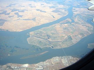
The Carquinez Strait is a narrow tidal strait located in the Bay Area of Northern California, United States. It is part of the tidal estuary of the Sacramento and the San Joaquin rivers as they drain into the San Francisco Bay. The strait is eight miles (13 km) long and connects Suisun Bay, which receives the waters of the combined rivers, with San Pablo Bay, a northern extension of the San Francisco Bay.
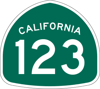
State Route 123 is a 7.39-mile (11.89 km) state highway in the U.S. state of California in the San Francisco Bay Area. Named San Pablo Avenue for almost its entire length except for its northernmost 0.10 miles (0.16 km), SR 123 is a major north–south state highway along the flats of the urban East Bay. Route 123 runs between Interstate 580 in Oakland in the south and Interstate 80 at Cutting Boulevard in Richmond in the north. San Pablo Avenue itself, a portion of Historic US 40, continues well past the SR 123 designation south to Downtown Oakland and north to Crockett.

The East Bay is the eastern region of the San Francisco Bay Area and includes cities along the eastern shores of the San Francisco Bay and San Pablo Bay. The region has grown to include inland communities in Alameda and Contra Costa counties. With a population of roughly 2.5 million in 2010, it is the most populous subregion in the Bay Area.
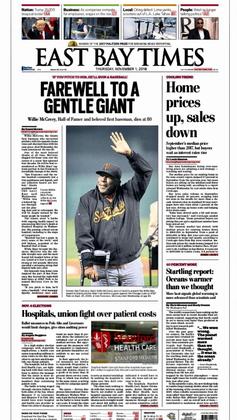
The East Bay Times is a daily broadsheet newspaper based in Walnut Creek, California, United States, owned by the Bay Area News Group (BANG), a subsidiary of Media News Group, that serves Contra Costa and Alameda counties, in the East Bay region of the San Francisco Bay Area. It was founded as the Contra Costa Times, and took its current name in 2016 when it was merged with other sister papers in the East Bay. Its oldest merged title is the Oakland Tribune founded in 1874.

The Brothers are a pair of small islands, East Brother and West Brother, located in the San Rafael Bay embayment of San Pablo Bay, these roughly 1,000 feet (300 m) west of Point San Pablo in Contra Costa County, California.

The Port of Stockton is a major deepwater port on the Stockton Ship Channel of the Pacific Ocean and an inland port located more than seventy nautical miles from the ocean, in Stockton, California on the Stockton Channel and San Joaquin River-Stockton Deepwater Shipping Channel. By land acreage, the Port of Stockton is the 2nd largest port in the State of California and sits on about 4,200 acres (17 km2), and occupies an island in the Sacramento–San Joaquin River Delta, and a portion of a neighborhood known as Boggs Tract. It is governed by a commission appointed by the City of Stockton and San Joaquin County. The Port of Stockton is a self-sustaining economic powerhouse in the Central Valley and in 2023, employed over 10,000 people and contributed over $78 million in state and local tax funds.

Alameda Creek is a large perennial stream in the San Francisco Bay Area. The creek runs for 45 miles (72 km) from a lake northeast of Packard Ridge to the eastern shore of San Francisco Bay by way of Niles Canyon and a flood control channel. Along its course, Alameda Creek provides wildlife habitat, water supply, a conduit for flood waters, opportunities for recreation, and a host of aesthetic and environmental values. The creek and three major reservoirs in the watershed are used as water supply by the San Francisco Public Utilities Commission, Alameda County Water District and Zone 7 Water Agency. Within the watershed can be found some of the highest peaks and tallest waterfall in the East Bay, over a dozen regional parks, and notable natural landmarks such as the cascades at Little Yosemite and the wildflower-strewn grasslands and oak savannahs of the Sunol Regional Wilderness. After an absence of half a century, ocean-run steelhead trout are able to return to Alameda Creek to mingle with remnant rainbow trout populations. Completion of a series of dam removal and fish passage projects, along with improved stream flows for cold-water fish and planned habitat restoration, enable steelhead trout and Chinook salmon to access up to 20 miles (32 km) of spawning and rearing habitat in Alameda Creek and its tributaries. The first juvenile trout migrating downstream from the upper watershed through lower Alameda Creek toward San Francisco Bay was detected and documented in April 2023.
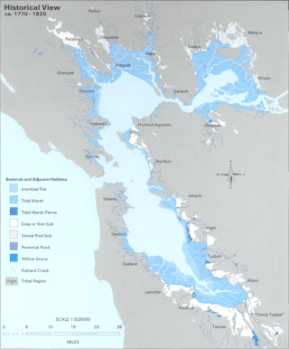
The Hydrography of the San Francisco Bay Area is a complex network of watersheds, marshes, rivers, creeks, reservoirs, and bays predominantly draining into the San Francisco Bay and Pacific Ocean.
The Western Pacific Railroad (1862–1870) was formed in 1862 to build a railroad from Sacramento, California, to the San Francisco Bay, the westernmost portion of the First transcontinental railroad. After the completion of the railroad from Sacramento to Alameda Terminal on September 6, 1869, and then the Oakland Pier on November 8, 1869, which was the Pacific coast terminus of the transcontinental railroad, the Western Pacific Railroad was absorbed in 1870 into the Central Pacific Railroad.
Al Bernardin was an American restaurateur and businessman who invented the McDonald's Quarter Pounder in 1971 as a franchise owner in Fremont, California. The creation of the Quarter Pounder earned him the nickname "Fremont's hamburger king."

Doggie Diner was a small fast food restaurant chain serving hot dogs and hamburgers in San Francisco and Oakland, California that operated from 1948 to 1986, owned by Al Ross.
The following is a timeline of the history of the city of Oakland, Alameda County, California, United States.
West Island is a small island in the San Joaquin River, California. It is part of Sacramento County. Its coordinates are 38°01′24″N121°46′43″W. It is shown, labeled "Webers Island", on an 1850 survey map of the San Francisco Bay area made by Cadwalader Ringgold and an 1854 map of the area by Henry Lange.

Kimball Island is a small island in the Sacramento–San Joaquin River Delta. It is located in Sacramento County, California, in the United States. Since its discovery, it has been used to grow barley, farm fish, cultivate cannabis, and as residential land. Currently, however, it is uninhabited; since 2000, it has been left to "forever be a wetland habitat", and is sometimes used as a fishing spot.

Chain Island is an island in Suisun Bay, downstream of the Sacramento–San Joaquin River Delta in northern California, and the westernmost piece of land in Sacramento County. In the late 1800s, it was considered an "obstruction to navigation" on the Sacramento River. As it was built up significantly from hydraulic mining tailings upstream on the river, plans were made in the early 20th century to remove it and recoup costs by mining the debris. However, this never happened; it was sold by the California State Lands Commission to a private individual in 1959, who listed it for sale the next year. In April 2016, the deed for the island was transferred; as of December 2022, Sacramento County assesses its land value at $18,622.
