National Register of Historic Places listings in Butler County, Kansas

Last updated

Location of Butler County in Kansas Map of Kansas highlighting Butler County.svg
Location of Butler County in Kansas

This is a list of the National Register of Historic Places listings in Butler County, Kansas.

Contents

This is intended to be a complete list of the properties on the National Register of Historic Places in Butler County, Kansas, United States. The locations of National Register properties for which the latitude and longitude coordinates are included below, may be seen in a map. [1]

There are 27 properties listed on the National Register in the county.


    This National Park Service list is complete through NPS recent listings posted March 4, 2022. [2]

Map all coordinates using: OpenStreetMap  
Download coordinates as: KML

Current listings

[3] Name on the Register [4] ImageDate listed [5] Location City or townDescription
1 Augusta Theater
Augusta Theater Augusta Theater NRHP 90001577 Butler County, KS.jpg
Augusta Theater
October 31, 1990
(#90001577)
525 State St.
37°40′37″N96°59′22″W / 37.6769°N 96.9894°W / 37.6769; -96.9894 (Augusta Theater)
Augusta
2 Beaumont Hotel February 3, 2012
(#11001078)
11651 SE Main St.
37°39′21″N96°31′58″W / 37.6559°N 96.5329°W / 37.6559; -96.5329 (Beaumont Hotel)
Beaumont
3 Beaumont St. Louis and San Francisco Railroad Retention Pond October 6, 2011
(#11000724)
SE 116th St. & SE Beaumont Rd.
37°39′19″N96°32′06″W / 37.6553°N 96.535°W / 37.6553; -96.535 (Beaumont St. Louis and San Francisco Railroad Retention Pond)
Beaumont
4 Beaumont St. Louis and San Francisco Railroad Water Tank
Beaumont St. Louis and San Francisco Railroad Water Tank Beaumont Kansas Water Tower.jpg
Beaumont St. Louis and San Francisco Railroad Water Tank
August 19, 1993
(#93000843)
Junction of 3rd and D Sts.
37°39′18″N96°31′51″W / 37.655°N 96.5308°W / 37.655; -96.5308 (Beaumont St. Louis and San Francisco Railroad Water Tank)
Beaumont Built in 1875, in Beaumont, Kansas, serving steam locomotives on the St. Louis, Wichita & Western Railway.
5 Butler County Courthouse
Butler County Courthouse El Dorado Courthouse, Butler County, Kansas.jpg
Butler County Courthouse
April 26, 2002
(#02000390)
205 W. Central Ave.
37°49′01″N96°51′06″W / 37.8169°N 96.8517°W / 37.8169; -96.8517 (Butler County Courthouse)
El Dorado On December 3, 1908, the corner stone was laid; construction was completed the following year. Architects, George P. Washburn & Sons of Ottawa.
6 Creed-Mills House June 25, 2013
(#13000430)
219 North Maple Street
37°31′17″N97°01′05″W / 37.5214°N 97.0180°W / 37.5214; -97.0180 (Creed-Mills House)
Douglass
7 Douglass Township Community Building
Douglass Township Community Building Douglass-township-community-building.jpg
Douglass Township Community Building
April 27, 1995
(#95000512)
206 S. Forest
37°31′05″N97°00′56″W / 37.5181°N 97.0156°W / 37.5181; -97.0156 (Douglass Township Community Building)
Douglass
8 El Dorado Carnegie Library
El Dorado Carnegie Library El Dorado, KS public library building funded by Andrew Carnegie.jpg
El Dorado Carnegie Library
June 25, 1987
(#87000931)
101 S. Star
37°49′00″N96°51′17″W / 37.8167°N 96.8547°W / 37.8167; -96.8547 (El Dorado Carnegie Library)
El Dorado
9 El Dorado Historic District
El Dorado Historic District El Dorado Kansas Pine Main Intersection.jpg
El Dorado Historic District
October 30, 2013
(#13000855)
Roughly 1 blk. E. & W. of N. & S. Main Sts. from E. 3rd to E. Locust Aves.
37°49′03″N96°50′59″W / 37.8174°N 96.8498°W / 37.8174; -96.8498 (El Dorado Historic District)
El Dorado
10 El Dorado Missouri Pacific Depot
El Dorado Missouri Pacific Depot Missouri Pacific Depot, El Dorado, Kansas.jpg
El Dorado Missouri Pacific Depot
May 6, 1994
(#94000429)
430 N. Main St.
37°49′18″N96°50′57″W / 37.8217°N 96.8492°W / 37.8217; -96.8492 (El Dorado Missouri Pacific Depot)
El Dorado A one-story red-brick building with a red-tile roof and wide, overhanging eaves, designed by E. M. Tucker, Chief Engineer of the Missouri Pacific, in the Mission architectural style. Built in 1918.
11 First Presbyterian Church of De Graff June 27, 2014
(#14000346)
1145 NW. 108th St, Burns, KS (mailing address)
37°58′51″N96°51′44″W / 37.9807°N 96.8621°W / 37.9807; -96.8621 (First Presbyterian Church of De Graff)
De Graff
12 Amos H. Gish Building
Amos H. Gish Building Gish Building El Dorado Kansas.jpg
Amos H. Gish Building
July 3, 2012
(#12000383)
317 S. Main
37°48′54″N96°51′01″W / 37.8149°N 96.8502°W / 37.8149; -96.8502 (Amos H. Gish Building)
El Dorado In 1917, Amos Gish commissioned T.R. Reed to build the Amos H. Gish Building. Amos Gish operated his veterinary practice and lived with his family on the second-story and leased the first-story front to retail and the rear as garage space to auto and storage businesses.
13 C. N. James Cabin
C. N. James Cabin Augusta-cj-james-trading-post.jpg
C. N. James Cabin
April 13, 1973
(#73000745)
305 State St.
37°39′53″N96°58′46″W / 37.6647°N 96.9794°W / 37.6647; -96.9794 (C. N. James Cabin)
Augusta
14 Little Walnut River Pratt Truss Bridge
Little Walnut River Pratt Truss Bridge Little Walnut River Pratt Truss Bridge 2.jpg
Little Walnut River Pratt Truss Bridge
May 9, 2003
(#03000377)
SW. 160th Rd., ½ mile west of its intersection with Purity Springs Rd.
37°35′46″N96°55′24″W / 37.5961°N 96.9233°W / 37.5961; -96.9233 (Little Walnut River Pratt Truss Bridge)
Bois D'Arc
15 Loomis-Parry Residence
Loomis-Parry Residence Loomis-Parry Residence NRHP 09000495 Butler County, KS.jpg
Loomis-Parry Residence
July 8, 2009
(#09000495)
1003 State St.
37°40′56″N96°58′44″W / 37.6823°N 96.9790°W / 37.6823; -96.9790 (Loomis-Parry Residence)
Augusta
16 John Moyle Building
John Moyle Building John-moyle-building.jpg
John Moyle Building
June 27, 2014
(#14000347)
605 & 607 N. State St.
37°40′40″N96°58′45″W / 37.6778°N 96.9792°W / 37.6778; -96.9792 (John Moyle Building)
Augusta
17 Muddy Creek Bridge July 2, 1985
(#85001425)
Off U.S. Route 77
37°32′03″N96°57′04″W / 37.5342°N 96.9511°W / 37.5342; -96.9511 (Muddy Creek Bridge)
Douglass
18 Oak Lawn Farm Dairy Barn November 5, 2005
(#05001202)
12464 NW. Meadowlark
38°00′24″N97°05′46″W / 38.0067°N 97.0961°W / 38.0067; -97.0961 (Oak Lawn Farm Dairy Barn)
Whitewater
19 James T. Oldham House
James T. Oldham House Oldham House NRHP 06001054 Butler County, KS.jpg
James T. Oldham House
November 21, 2006
(#06001054)
321 S. Denver St.
37°48′53″N96°51′23″W / 37.8147°N 96.8564°W / 37.8147; -96.8564 (James T. Oldham House)
El Dorado
20 Polecat Creek Bridge
Polecat Creek Bridge PolecatBridge.jpg
Polecat Creek Bridge
July 2, 1985
(#85001438)
5 miles west and 2 miles south of Douglass
37°29′23″N97°06′33″W / 37.4897°N 97.1092°W / 37.4897; -97.1092 (Polecat Creek Bridge)
Douglass
21 Ray L. Smith House
Ray L. Smith House Ray L. Smith House NRHP 14001117 Butler County, KS.jpg
Ray L. Smith House
January 7, 2015
(#14001117)
812 W. Central Ave.
37°49′03″N96°51′37″W / 37.8175°N 96.8603°W / 37.8175; -96.8603 (Ray L. Smith House)
El Dorado
22 Towanda Masonic Lodge No. 30 A.F. and A.M. January 14, 2004
(#03001392)
401 Main St.
37°47′44″N97°00′09″W / 37.7956°N 97.0025°W / 37.7956; -97.0025 (Towanda Masonic Lodge No. 30 A.F. and A.M.)
Towanda
23 US Post Office-Augusta
US Post Office-Augusta US Post Office - Augusta NRHP 89001632 Butler County, KS.jpg
US Post Office-Augusta
October 17, 1989
(#89001632)
119 E. 5th St.
37°40′33″N96°58′38″W / 37.6758°N 96.9772°W / 37.6758; -96.9772 (US Post Office-Augusta)
Augusta
24 Viets Block
Viets Block Viets Block NRHP 12000202 Butler County, KS.jpg
Viets Block
April 16, 2012
(#12000202)
427, 429, & 431 State St.
37°40′34″N96°58′45″W / 37.6760°N 96.9793°W / 37.6760; -96.9793 (Viets Block)
Augusta
25 Walnut River Crossing of the Cherokee/Fayetteville Oregon-California Trail September 30, 2019
(#100004457)
Address Restricted
El Dorado
26 Whitewater Falls Stock Farm October 8, 2014
(#14000828)
433 Falls Rd.
37°49′53″N97°02′20″W / 37.8313°N 97.0388°W / 37.8313; -97.0388 (Whitewater Falls Stock Farm)
Towanda
27 Yingling Brothers Auto Company
Yingling Brothers Auto Company Yingling Brothers Auto Co. NRHP 11000409 Butler County, KS.jpg
Yingling Brothers Auto Company
July 5, 2011
(#11000409)
411 S. Main St.
37°48′51″N96°51′01″W / 37.8142°N 96.8503°W / 37.8142; -96.8503 (Yingling Brothers Auto Company)
El Dorado Roadside Kansas MPS

See also

Related Research Articles

National Register of Historic Places listings in Butler County, Pennsylvania

This is a list of the National Register of Historic Places listings in Butler County, Pennsylvania.

National Register of Historic Places listings in Doniphan County, Kansas

This is a list of the National Register of Historic Places listings in Doniphan County, Kansas.

National Register of Historic Places listings in Harvey County, Kansas

This is a list of the National Register of Historic Places listings in Harvey County, Kansas.

National Register of Historic Places listings in Morris County, Kansas

This is a list of the National Register of Historic Places listings in Morris County, Kansas.

National Register of Historic Places listings in Sedgwick County, Kansas

This is a list of the National Register of Historic Places listings in Sedgwick County, Kansas.

National Register of Historic Places listings in Chase County, Kansas

This is a list of the National Register of Historic Places listings in Chase County, Kansas.

National Register of Historic Places listings in Franklin County, Kansas

This is a list of the National Register of Historic Places listings in Franklin County, Kansas.

National Register of Historic Places listings in Johnson County, Kansas

This is a list of the National Register of Historic Places listings in Johnson County, Kansas.

National Register of Historic Places listings in Reno County, Kansas

This is a list of the National Register of Historic Places listings in Reno County, Kansas.

National Register of Historic Places listings in Saline County, Kansas

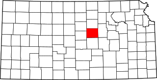
This is a list of the National Register of Historic Places listings in Saline County, Kansas.

National Register of Historic Places listings in Nemaha County, Kansas

This is a list of the National Register of Historic Places listings in Nemaha County, Kansas.

National Register of Historic Places listings in Crawford County, Kansas

This is a list of the National Register of Historic Places listings in Crawford County, Kansas.

National Register of Historic Places listings in Labette County, Kansas

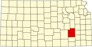
This is a list of the National Register of Historic Places listings in Labette County, Kansas.

National Register of Historic Places listings in Cloud County, Kansas

This is a list of the National Register of Historic Places listings in Cloud County, Kansas.

National Register of Historic Places listings in Greenwood County, Kansas

This is a list of the National Register of Historic Places listings in Greenwood County, Kansas.

National Register of Historic Places listings in Ford County, Kansas

This is a list of the National Register of Historic Places listings in Ford County, Kansas.

National Register of Historic Places listings in Brown County, Kansas

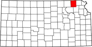
This is a list of the National Register of Historic Places listings in Brown County, Kansas.

National Register of Historic Places listings in Wabaunsee County, Kansas

This is a list of the National Register of Historic Places listings in Wabaunsee County, Kansas.

National Register of Historic Places listings in Republic County, Kansas

This is a list of the National Register of Historic Places listings in Republic County, Kansas.

National Register of Historic Places listings in Butler County, Missouri

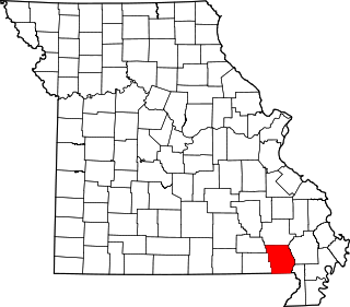
This is a list of the National Register of Historic Places listings in Butler County, Missouri.

References

  1. The latitude and longitude information provided in this table was derived originally from the National Register Information System, which has been found to be fairly accurate for about 99% of listings. Some locations in this table may have been corrected to current GPS standards.
  2. National Park Service, United States Department of the Interior, "National Register of Historic Places: Weekly List Actions", retrieved March 4, 2022.
  3. Numbers represent an alphabetical ordering by significant words. Various colorings, defined here, differentiate National Historic Landmarks and historic districts from other NRHP buildings, structures, sites or objects.
  4. "National Register Information System". National Register of Historic Places . National Park Service. March 13, 2009.
  5. The eight-digit number below each date is the number assigned to each location in the National Register Information System database, which can be viewed by clicking the number.