National Register of Historic Places listings in Marshall County, Kansas

Last updated
Location of Marshall County in Kansas Map of Kansas highlighting Marshall County.svg
Location of Marshall County in Kansas

This is a list of the National Register of Historic Places listings in Marshall County, Kansas.

Contents

This is intended to be a complete list of the properties and districts on the National Register of Historic Places in Marshall County, Kansas, United States. The locations of National Register properties and districts for which the latitude and longitude coordinates are included below, may be seen in a map. [1]

There are 21 properties and districts listed on the National Register in the county.

This National Park Service list is complete through NPS recent listings posted March 26, 2021. [2]
Map all coordinates using: OpenStreetMap  
Download coordinates as: KML

Current listings

[3] Name on the Register [4] ImageDate listed [5] Location City or townDescription
1 Alcove Springs
Alcove Springs Alcove Spring, Marshall County, Kansas.jpg
Alcove Springs
February 23, 1972
(#72000513)
4 miles (6.4 km) north of Blue Rapids; E. River Rd
39°44′56″N96°40′35″W / 39.748889°N 96.676389°W / 39.748889; -96.676389 (Alcove Springs)
Blue Rapids Boundary increase September 25, 2013
2 Barrett Schoolhouse
Barrett Schoolhouse Barrett Schoolhouse Frankfort Kansas front view.jpg
Barrett Schoolhouse
March 14, 1973
(#73000766)
4 miles (6.4 km) southwest of Frankfort on K-99
39°39′59″N96°27′06″W / 39.666389°N 96.451667°W / 39.666389; -96.451667 (Barrett Schoolhouse)
Frankfort
3 Blue Rapids Library
Blue Rapids Library Blue Rapids Public Library exterior.jpg
Blue Rapids Library
March 17, 1972
(#72000514)
Eastern side of the public square
39°40′55″N96°39′29″W / 39.681944°N 96.658056°W / 39.681944; -96.658056 (Blue Rapids Library)
Blue Rapids
4 Frankfort School
Frankfort School Frankfort School Kansas front view.jpg
Frankfort School
December 27, 1972
(#72000515)
400 Locust St.
39°42′17″N96°25′01″W / 39.704722°N 96.416944°W / 39.704722; -96.416944 (Frankfort School)
Frankfort
5 Perry Hutchinson House
Perry Hutchinson House Perry Hutchinson house (Marysville KS) from NE 1.JPG
Perry Hutchinson House
April 13, 1972
(#72000516)
1 mile (1.6 km) northwest of Marysville on U.S. Route 77
39°51′02″N96°40′02″W / 39.850521°N 96.667222°W / 39.850521; -96.667222 (Perry Hutchinson House)
Marysville
6 Koester Block Historic District
Koester Block Historic District Las Cabanas, 908 Elm St, Marysville, KS (5100507244).jpg
Koester Block Historic District
December 5, 1980
(#80001469)
Between 9th, 10th, Elm, and Broadway Sts.
39°50′29″N96°38′44″W / 39.841389°N 96.645556°W / 39.841389; -96.645556 (Koester Block Historic District)
Marysville
7 Charles Koester House
Charles Koester House Koester House Mville KS.JPG
Charles Koester House
May 12, 1975
(#75000715)
919 Broadway
39°50′29″N96°38′44″W / 39.841389°N 96.645556°W / 39.841389; -96.645556 (Charles Koester House)
Marysville
8 Marshall County Courthouse
Marshall County Courthouse Marshall Co KS Courthouse.JPG
Marshall County Courthouse
November 5, 1974
(#74000843)
1207 Broadway
39°50′32″N96°38′31″W / 39.842222°N 96.641944°W / 39.842222; -96.641944 (Marshall County Courthouse)
Marysville
9 Marysville High School-Junior High School Complex
Marysville High School-Junior High School Complex Marysville, Kansas high school N side center relief 1.JPG
Marysville High School-Junior High School Complex
January 2, 2013
(#12001120)
1011-1111 Walnut St.
39°50′23″N96°38′41″W / 39.839609°N 96.644788°W / 39.839609; -96.644788 (Marysville High School-Junior High School Complex)
Marysville
10 Marysville Pony Express Barn
Marysville Pony Express Barn Pony Express Marysville KS.JPG
Marysville Pony Express Barn
April 2, 1973
(#73000767)
108 S. 8th St.
39°50′27″N96°38′51″W / 39.840833°N 96.6475°W / 39.840833; -96.6475 (Marysville Pony Express Barn)
Marysville
11 Marysville Union Pacific Depot
Marysville Union Pacific Depot Marysville Union Pacific Depot Kansas front detail.jpg
Marysville Union Pacific Depot
October 11, 2016
(#16000709)
000 Hedrix Ave. (at Alston St.)
39°50′39″N96°38′56″W / 39.844173°N 96.649004°W / 39.844173; -96.649004 (Marysville Union Pacific Depot)
Marysville
12 Z. H. Moore Store
Z. H. Moore Store Z H Moore General Store exterior right side.jpg
Z. H. Moore Store
June 24, 1976
(#76000830)
State and Center Sts.
39°57′53″N96°36′01″W / 39.964722°N 96.600278°W / 39.964722; -96.600278 (Z. H. Moore Store)
Oketo
13 Old Frankfort City Jail
Old Frankfort City Jail Frankfort Jail Kansas.jpg
Old Frankfort City Jail
November 1, 1982
(#82000418)
Railway Ave.
39°42′05″N96°25′02″W / 39.701389°N 96.417222°W / 39.701389; -96.417222 (Old Frankfort City Jail)
Frankfort
14 Oregon and California Trail--Pacha Ruts January 8, 2014
(#13001040)
Address Restricted
Bremen vicinity
15 Samuel Powell House
Samuel Powell House Samuel Powell House Waterville Kansas 1.jpg
Samuel Powell House
December 27, 1972
(#72000517)
108 W. Commercial St.
39°41′34″N96°44′59″W / 39.692793°N 96.749784°W / 39.692793; -96.749784 (Samuel Powell House)
Waterville
16 Pusch-Randell House
Pusch-Randell House Pusch-Randell House - Marysville, Kansas (3918254855).jpg
Pusch-Randell House
September 22, 1986
(#86002680)
1000 Elm St.
39°50′30″N96°38′48″W / 39.841667°N 96.646667°W / 39.841667; -96.646667 (Pusch-Randell House)
Marysville
17 Robidoux Creek Pratt Truss Bridge
Robidoux Creek Pratt Truss Bridge Robidoux Creek Pratt Truss Bridge Kansas.jpg
Robidoux Creek Pratt Truss Bridge
May 22, 2003
(#03000474)
Sunflower Rd., 0.8 miles (1.3 km) west of its junction with 21st Rd., northwest of Frankfort
39°43′33″N96°26′26″W / 39.725833°N 96.440556°W / 39.725833; -96.440556 (Robidoux Creek Pratt Truss Bridge)
Frankfort
18 St. Bridget Church
St. Bridget Church St Bridget's exterior front DSC 7666.jpg
St. Bridget Church
September 12, 1996
(#96001011)
Rural Route 2, 6.5 miles (10.5 km) north of Axtell
39°57′58″N96°15′48″W / 39.966111°N 96.263333°W / 39.966111; -96.263333 (St. Bridget Church)
St. Bridget Township
19 Transue Brothers Blacksmith & Wagon Shop
Transue Brothers Blacksmith & Wagon Shop Transue Brothers front exterior.jpg
Transue Brothers Blacksmith & Wagon Shop
December 30, 2009
(#09001164)
309 Main St.
39°59′54″N96°20′55″W / 39.998344°N 96.348558°W / 39.998344; -96.348558 (Transue Brothers Blacksmith & Wagon Shop)
Summerfield
20 Waterville Opera House
Waterville Opera House Waterville Opera House.JPG
Waterville Opera House
October 16, 2008
(#08000984)
200 E. Front St.
39°41′29″N96°44′51″W / 39.691389°N 96.7475°W / 39.691389; -96.7475 (Waterville Opera House)
Waterville
21 Weaver Hotel
Weaver Hotel Weaver Hotel.JPG
Weaver Hotel
August 28, 1975
(#75000716)
126 S. Kansas St.
39°41′30″N96°44′51″W / 39.691667°N 96.7475°W / 39.691667; -96.7475 (Weaver Hotel)
Waterville

See also

Related Research Articles

National Register of Historic Places listings in Marshall County, Alabama

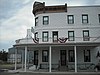
This is a list of the National Register of Historic Places listings in Marshall County, Alabama.

National Register of Historic Places listings in Doniphan County, Kansas

This is a list of the National Register of Historic Places listings in Doniphan County, Kansas.

National Register of Historic Places listings in Harvey County, Kansas

This is a list of the National Register of Historic Places listings in Harvey County, Kansas.

National Register of Historic Places listings in Morris County, Kansas

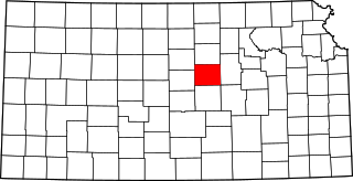
This is a list of the National Register of Historic Places listings in Morris County, Kansas.

National Register of Historic Places listings in Sedgwick County, Kansas

This is a list of the National Register of Historic Places listings in Sedgwick County, Kansas.

National Register of Historic Places listings in Chase County, Kansas

This is a list of the National Register of Historic Places listings in Chase County, Kansas.

National Register of Historic Places listings in Franklin County, Kansas

This is a list of the National Register of Historic Places listings in Franklin County, Kansas.

National Register of Historic Places listings in Johnson County, Kansas

This is a list of the National Register of Historic Places listings in Johnson County, Kansas.

National Register of Historic Places listings in Reno County, Kansas

This is a list of the National Register of Historic Places listings in Reno County, Kansas.

National Register of Historic Places listings in Saline County, Kansas

This is a list of the National Register of Historic Places listings in Saline County, Kansas.

National Register of Historic Places listings in Nemaha County, Kansas

This is a list of the National Register of Historic Places listings in Nemaha County, Kansas.

National Register of Historic Places listings in Crawford County, Kansas

This is a list of the National Register of Historic Places listings in Crawford County, Kansas.

National Register of Historic Places listings in Cloud County, Kansas

This is a list of the National Register of Historic Places listings in Cloud County, Kansas.

National Register of Historic Places listings in Miami County, Kansas

This is a list of the National Register of Historic Places listings in Miami County, Kansas.

National Register of Historic Places listings in Mitchell County, Kansas

This is a list of the National Register of Historic Places listings in Mitchell County, Kansas.

National Register of Historic Places listings in Finney County, Kansas

This is a list of the National Register of Historic Places listings in Finney County, Kansas.

National Register of Historic Places listings in Brown County, Kansas

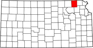
This is a list of the National Register of Historic Places listings in Brown County, Kansas.

National Register of Historic Places listings in Wabaunsee County, Kansas

This is a list of the National Register of Historic Places listings in Wabaunsee County, Kansas.

National Register of Historic Places listings in Republic County, Kansas

This is a list of the National Register of Historic Places listings in Republic County, Kansas.

National Register of Historic Places listings in Marshall County, West Virginia

This is a list of the National Register of Historic Places listings in Marshall County, West Virginia.

References

  1. The latitude and longitude information provided in this table was derived originally from the National Register Information System, which has been found to be fairly accurate for about 99% of listings. Some locations in this table may have been corrected to current GPS standards.
  2. "National Register of Historic Places: Weekly List Actions". National Park Service, United States Department of the Interior. Retrieved on March 26, 2021.
  3. Numbers represent an alphabetical ordering by significant words. Various colorings, defined here, differentiate National Historic Landmarks and historic districts from other NRHP buildings, structures, sites or objects.
  4. "National Register Information System". National Register of Historic Places . National Park Service. March 13, 2009.
  5. The eight-digit number below each date is the number assigned to each location in the National Register Information System database, which can be viewed by clicking the number.