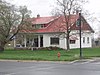
[3] Name on the Register Image Date listed [4] Location City or town Description 1 George Washington Baker House George Washington Baker House February 10, 1983 (# 83004416 115 N. 100 West 41°42′37″N 111°58′44″W / 41.710278°N 111.978889°W / 41.710278; -111.978889 (George Washington Baker House ) Mendon 2 Samuel Baker House Upload image March 31, 1983 (# 83004417 150 W. 200 North 41°42′45″N 111°58′50″W / 41.7125°N 111.980694°W / 41.7125; -111.980694 (Samuel Baker House ) Mendon Stone house with vernacular Greek Revival styling, built in 1870s. 3 Heber K. and Rachel H. Bankhead House Heber K. and Rachel H. Bankhead House March 21, 1997 (# 97000261 185 E. 800 South 41°37′20″N 111°55′49″W / 41.622222°N 111.930278°W / 41.622222; -111.930278 (Heber K. and Rachel H. Bankhead House ) Wellsville 4 William & Elizabeth Barrett Farmstead William & Elizabeth Barrett Farmstead February 19, 2008 (# 08000057 20 S. 100 West 41°42′27″N 111°58′42″W / 41.7075°N 111.978333°W / 41.7075; -111.978333 (William & Elizabeth Barrett Farmstead ) Mendon 5 Bell-Johnson House Bell-Johnson House October 8, 2004 (# 04001118 12 N. 200 East 41°55′30″N 111°48′05″W / 41.925°N 111.801389°W / 41.925; -111.801389 (Bell-Johnson House ) Richmond 6 Benson Elementary School Upload image April 1, 1985 (# 85000798 3440 N. 3000 West 41°47′45″N 111°54′17″W / 41.795833°N 111.904722°W / 41.795833; -111.904722 (Benson Elementary School ) Benson Demolished between 1993 and 2002 7 Borden Company Plant Upload image September 20, 2021 (# 100006935 290 South 400 West 41°43′35″N 111°50′43″W / 41.7265°N 111.8454°W / 41.7265; -111.8454 (Borden Company Plant ) Logan 8 George Bradshaw House and Joshua Salisbury/George Bradshaw Barn George Bradshaw House and Joshua Salisbury/George Bradshaw Barn November 19, 1982 (# 82004846 73 S. Center St. 41°38′16″N 111°56′05″W / 41.637778°N 111.934722°W / 41.637778; -111.934722 (George Bradshaw House and Joshua Salisbury/George Bradshaw Barn ) Wellsville 9 James and Amy Burnham Farmstead James and Amy Burnham Farmstead October 8, 2004 (# 04001120 533 S. State St. 41°54′46″N 111°48′27″W / 41.912778°N 111.8075°W / 41.912778; -111.8075 (James and Amy Burnham Farmstead ) Richmond 10 Carl F. and Sophia Christensen House Carl F. and Sophia Christensen House October 8, 2004 (# 04001121 208 N. 200 East 41°55′38″N 111°48′06″W / 41.927222°N 111.801667°W / 41.927222; -111.801667 (Carl F. and Sophia Christensen House ) Richmond 11 Clarkston Tithing Granary Clarkston Tithing Granary January 25, 1985 (# 85000250 10212 N. 8700 West 41°55′12″N 112°03′11″W / 41.919944°N 112.053056°W / 41.919944; -112.053056 (Clarkston Tithing Granary ) Clarkston Granary building. This was moved a few blocks in 2018. 12 Crockett House Crockett House April 27, 2009 (# 09000017 82 Crockett Ave. 41°44′04″N 111°48′44″W / 41.73445°N 111.812172°W / 41.73445; -111.812172 (Crockett House ) Logan 13 Douglas General Mercantile Douglas General Mercantile August 4, 1982 (# 82004113 100 S. Main St. 41°50′03″N 111°49′54″W / 41.834167°N 111.831667°W / 41.834167; -111.831667 (Douglas General Mercantile ) Smithfield 14 David Eccles House David Eccles House July 30, 1976 (# 76001811 250 W. Center St. 41°43′52″N 111°50′26″W / 41.731111°N 111.840556°W / 41.731111; -111.840556 (David Eccles House ) Logan 15 Elite Hall Elite Hall August 4, 2003 (# 03000736 98 W. Main St. 41°38′04″N 111°51′25″W / 41.634444°N 111.856944°W / 41.634444; -111.856944 (Elite Hall ) Hyrum 16 Samuel and Lana Ewing House Samuel and Lana Ewing House January 28, 1994 (# 93001576 107 S. 100 East 41°50′02″N 111°49′46″W / 41.833889°N 111.829444°W / 41.833889; -111.829444 (Samuel and Lana Ewing House ) Smithfield 17 Forster Hotel Forster Hotel February 19, 2008 (# 08000058 176 N. 100 West 41°42′40″N 111°58′41″W / 41.711111°N 111.978056°W / 41.711111; -111.978056 (Forster Hotel ) Mendon 18 James Gardner House James Gardner House February 11, 1982 (# 82004111 173 N. Main St. 41°42′39″N 111°58′34″W / 41.710833°N 111.976111°W / 41.710833; -111.976111 (James Gardner House ) Mendon 19 Soren Hanson House Soren Hanson House February 11, 1982 (# 82004109 166 W. Main St. 41°38′04″N 111°51′33″W / 41.634444°N 111.859167°W / 41.634444; -111.859167 (Soren Hanson House ) Hyrum 20 Martin Harris Gravesite Martin Harris Gravesite November 28, 1980 (# 80003890 8400 W. 11000 North 41°55′53″N 112°02′20″W / 41.931389°N 112.038889°W / 41.931389; -112.038889 (Martin Harris Gravesite ) Clarkston 21 Hatch's Camp Upload image December 27, 2006 (# 06001192 8.3 miles (13.4 km) east from the mouth of Logan Canyon 41°46′32″N 111°38′57″W / 41.775556°N 111.649167°W / 41.775556; -111.649167 (Hatch's Camp ) Cache National Forest 22 Hendricks Confectionery Building Hendricks Confectionery Building October 8, 2004 (# 04001122 19 W. Main St. 41°55′21″N 111°48′31″W / 41.9225°N 111.808611°W / 41.9225; -111.808611 (Hendricks Confectionery Building ) Richmond 23 Lafayette and Elizabeth W. Hendricks House Lafayette and Elizabeth W. Hendricks House October 8, 2004 (# 04001123 109 S. State St. 41°55′13″N 111°48′27″W / 41.920278°N 111.8075°W / 41.920278; -111.8075 (Lafayette and Elizabeth W. Hendricks House ) Richmond 24 William S. and Margaret R. Hendricks House William S. and Margaret R. Hendricks House October 8, 2004 (# 04001124 112 W. Main St. 41°55′23″N 111°48′40″W / 41.923056°N 111.811111°W / 41.923056; -111.811111 (William S. and Margaret R. Hendricks House ) Richmond 25 Hobson-Hill House Hobson-Hill House October 8, 2004 (# 04001125 108 S. 100 West 41°55′13″N 111°48′40″W / 41.920278°N 111.811111°W / 41.920278; -111.811111 (Hobson-Hill House ) Richmond 26 Home Economics/Commons Building Home Economics/Commons Building April 1, 1985 (# 85000800 Off U.S. Route 89 on the Utah State University campus 41°44′25″N 111°48′40″W / 41.740278°N 111.811111°W / 41.740278; -111.811111 (Home Economics/Commons Building ) Logan 27 Howell-Theurer House Howell-Theurer House October 18, 1979 (# 79002490 30 S. 100 East 41°38′16″N 111°55′49″W / 41.637778°N 111.930278°W / 41.637778; -111.930278 (Howell-Theurer House ) Wellsville Boyhood home of Joseph Howell 28 Hyrum First Ward Meetinghouse Hyrum First Ward Meetinghouse February 15, 1980 (# 80003891 290 S. Center St. 41°37′41″N 111°51′19″W / 41.628056°N 111.855278°W / 41.628056; -111.855278 (Hyrum First Ward Meetinghouse ) Hyrum 29 John P. and Sarah James House John P. and Sarah James House January 28, 1994 (# 93001578 210 W. 9000 South 41°34′06″N 111°50′17″W / 41.568333°N 111.838056°W / 41.568333; -111.838056 (John P. and Sarah James House ) Paradise 30 Morgan A. and Clarissa R. Knapp House Morgan A. and Clarissa R. Knapp House October 8, 2004 (# 04001126 106 S. 100 East 41°55′13″N 111°48′19″W / 41.920278°N 111.805278°W / 41.920278; -111.805278 (Morgan A. and Clarissa R. Knapp House ) Richmond 31 John E. Lee House John E. Lee House February 11, 1982 (# 82004108 123 W. Center St. 41°28′33″N 111°29′32″W / 41.47581°N 111.492111°W / 41.47581; -111.492111 (John E. Lee House ) Hyde Park 32 Lewiston Community Building Lewiston Community Building April 1, 1985 (# 85000799 29 S. Main St. 41°58′31″N 111°51′20″W / 41.975278°N 111.855556°W / 41.975278; -111.855556 (Lewiston Community Building ) Lewiston 33 Lewiston Tithing Office and Granary Lewiston Tithing Office and Granary January 25, 1985 (# 85000252 81 E. 800 South 41°57′42″N 111°51′14″W / 41.961667°N 111.853889°W / 41.961667; -111.853889 (Lewiston Tithing Office and Granary ) Lewiston 34 Logan Center Street Historic District Logan Center Street Historic District April 26, 1979 (# 79002488 Roughly bounded by 200 North, 200 South, 200 East, and 600 West 41°43′56″N 111°50′18″W / 41.732222°N 111.838333°W / 41.732222; -111.838333 (Logan Center Street Historic District ) Logan 35 Logan Fish Hatchery Caretaker's Residence Logan Fish Hatchery Caretaker's Residence April 1, 1985 (# 85000801 1469 W. 200 North 41°44′10″N 111°52′08″W / 41.736111°N 111.868889°W / 41.736111; -111.868889 (Logan Fish Hatchery Caretaker's Residence ) Logan 36 Logan High School Gymnasium Upload image August 7, 1985 (# 85001844 162 W. 100 South 41°43′44″N 111°50′16″W / 41.728889°N 111.837778°W / 41.728889; -111.837778 (Logan High School Gymnasium ) Logan 37 Logan LDS Sixth Ward Church Logan LDS Sixth Ward Church July 17, 1979 (# 79002489 395 S. Main St. 41°43′27″N 111°50′06″W / 41.724167°N 111.835°W / 41.724167; -111.835 (Logan LDS Sixth Ward Church ) Logan 38 Logan Municipal Slaughterhouse Logan Municipal Slaughterhouse April 1, 1985 (# 85000802 265 N. 600 West 41°44′13″N 111°50′59″W / 41.736944°N 111.849722°W / 41.736944; -111.849722 (Logan Municipal Slaughterhouse ) Logan 39 Logan Tabernacle Logan Tabernacle October 10, 1975 (# 75001800 Bounded by Center, 1st North, Main, and 1st East Sts. 41°43′56″N 111°50′00″W / 41.732222°N 111.833333°W / 41.732222; -111.833333 (Logan Tabernacle ) Logan 40 Logan Temple Logan Temple November 20, 1975 (# 75001801 Between 2nd and 3rd East and 1st and 2nd North 41°44′03″N 111°49′38″W / 41.734167°N 111.827222°W / 41.734167; -111.827222 (Logan Temple ) Logan 41 Logan Temple Barn Logan Temple Barn December 19, 1985 (# 85003199 368 E. 200 North 41°44′06″N 111°49′27″W / 41.735°N 111.824167°W / 41.735; -111.824167 (Logan Temple Barn ) Logan 42 McMurdie-White Farmstead McMurdie-White Farmstead September 28, 2005 (# 05001106 395 W. 9000 South 41°34′10″N 111°50′47″W / 41.569444°N 111.846389°W / 41.569444; -111.846389 (McMurdie-White Farmstead ) Paradise 43 Mendon Station Mendon Station February 19, 2008 (# 08000059 95 N. Main St. 41°42′34″N 111°58′34″W / 41.709444°N 111.976111°W / 41.709444; -111.976111 (Mendon Station ) Mendon 44 Louis Edgar and Clara H. Merrill House Louis Edgar and Clara H. Merrill House October 8, 2004 (# 04001127 244 W. Main St. 41°55′23″N 111°48′53″W / 41.923056°N 111.814722°W / 41.923056; -111.814722 (Louis Edgar and Clara H. Merrill House ) Richmond 45 Samuel Crowthers Mitton House Samuel Crowthers Mitton House November 19, 1982 (# 82004847 242 E. Main St. 41°38′18″N 111°55′36″W / 41.638333°N 111.926667°W / 41.638333; -111.926667 (Samuel Crowthers Mitton House ) Wellsville 46 Hattie Merrill Morrison Farmstead Hattie Merrill Morrison Farmstead October 8, 2004 (# 04001128 1367 S. State St. 41°53′48″N 111°48′34″W / 41.896667°N 111.809444°W / 41.896667; -111.809444 (Hattie Merrill Morrison Farmstead ) Richmond 47 Muir House Muir House April 4, 2008 (# 08000060 145 S. Main St. 41°42′17″N 111°58′36″W / 41.70482°N 111.9766°W / 41.70482; -111.9766 (Muir House ) Mendon 48 Newton Reservoir Upload image November 30, 1973 (# 73001860 3 miles (4.8 km) north of Newton 41°54′36″N 112°00′18″W / 41.91°N 112.005°W / 41.91; -112.005 (Newton Reservoir ) Newton 49 Old Main, Utah State University Old Main, Utah State University February 23, 1972 (# 72001258 Utah State University campus 41°44′27″N 111°48′47″W / 41.740833°N 111.813056°W / 41.740833; -111.813056 (Old Main, Utah State University ) Logan 50 Erick Lehi and Ingrid Larsen Olson House Erick Lehi and Ingrid Larsen Olson House March 8, 1997 (# 97000225 490 E. 600 South 41°43′18″N 111°49′19″W / 41.721667°N 111.821944°W / 41.721667; -111.821944 (Erick Lehi and Ingrid Larsen Olson House ) River Heights 51 Paradise Tithing Office Paradise Tithing Office January 25, 1985 (# 85000253 8970 S. 200 West 41°34′09″N 111°50′14″W / 41.569167°N 111.837222°W / 41.569167; -111.837222 (Paradise Tithing Office ) Paradise 52 Martin and Martha Pond Farmstead Martin and Martha Pond Farmstead November 17, 1997 (# 97001308 320 S. 800 West 41°58′13″N 111°52′11″W / 41.970278°N 111.869722°W / 41.970278; -111.869722 (Martin and Martha Pond Farmstead ) Lewiston 53 Providence Historic District Providence Historic District November 9, 2007 (# 07001169 Roughly bounded by 200 N., 400 E., 500 S., and 200 W. 41°42′18″N 111°48′56″W / 41.705°N 111.815556°W / 41.705; -111.815556 (Providence Historic District ) Providence 54 Providence LDS Chapel and Meetinghouse Providence LDS Chapel and Meetinghouse February 11, 1982 (# 82004112 10 S. Main St. 41°42′28″N 111°49′00″W / 41.707778°N 111.816667°W / 41.707778; -111.816667 (Providence LDS Chapel and Meetinghouse ) Providence 55 Richmond Carnegie Library Richmond Carnegie Library October 25, 1984 (# 84000147 38 W. Main St. 41°55′23″N 111°48′32″W / 41.923056°N 111.808889°W / 41.923056; -111.808889 (Richmond Carnegie Library ) Richmond 56 Richmond City Grandstand & Baseball Field Richmond City Grandstand & Baseball Field April 29, 2005 (# 04001130 Approximately 50 S. State St. 41°55′17″N 111°48′34″W / 41.921389°N 111.809444°W / 41.921389; -111.809444 (Richmond City Grandstand & Baseball Field ) Richmond 57 Richmond Community Building Richmond Community Building April 9, 1986 (# 86000731 6 W. Main St. 41°55′23″N 111°48′30″W / 41.923056°N 111.808333°W / 41.923056; -111.808333 (Richmond Community Building ) Richmond 58 Richmond Interurban Depot Richmond Interurban Depot May 16, 2002 (# 02000508 196 W. Main St. 41°54′51″N 111°48′48″W / 41.914167°N 111.813333°W / 41.914167; -111.813333 (Richmond Interurban Depot ) Richmond 59 Richmond Relief Society Hall Richmond Relief Society Hall June 7, 1996 (# 96000589 15 E. Main St. 41°55′31″N 111°48′27″W / 41.925278°N 111.8075°W / 41.925278; -111.8075 (Richmond Relief Society Hall ) Richmond 60 Richmond Tithing Office Richmond Tithing Office January 25, 1985 (# 85000256 31 S. State St. 41°55′20″N 111°48′27″W / 41.922222°N 111.8075°W / 41.922222; -111.8075 (Richmond Tithing Office ) Richmond 61 Zial Riggs House Zial Riggs House February 11, 1982 (# 82004114 94 S. 100 East 41°38′13″N 111°55′49″W / 41.636944°N 111.930278°W / 41.636944; -111.930278 (Zial Riggs House ) Wellsville 62 River Heights Sinclair Station River Heights Sinclair Station June 12, 2017 (# 100001077 594 S. 400 East 41°43′18″N 111°49′32″W / 41.721596°N 111.825586°W / 41.721596; -111.825586 (River Heights Sinclair Station ) River Heights 63 Sigma Chi Fraternity House Sigma Chi Fraternity House September 15, 2005 (# 05001038 705 N. 800 East 41°44′42″N 111°48′52″W / 41.745°N 111.814444°W / 41.745; -111.814444 (Sigma Chi Fraternity House ) Logan 64 William McNeil Smith House William McNeil Smith House February 11, 1982 (# 82004110 116 S. 100 East 41°43′44″N 111°49′53″W / 41.728889°N 111.831389°W / 41.728889; -111.831389 (William McNeil Smith House ) Logan 65 Smithfield Public Library Smithfield Public Library February 17, 1981 (# 81000580 25 N. Main St. 41°50′14″N 111°49′13″W / 41.837222°N 111.820278°W / 41.837222; -111.820278 (Smithfield Public Library ) Smithfield 66 Smithfield Tabernacle-Youth Center Smithfield Tabernacle-Youth Center January 17, 2017 (# 100000509 25 N. Main St. 41°50′13″N 111°49′59″W / 41.837006°N 111.832951°W / 41.837006; -111.832951 (Smithfield Tabernacle-Youth Center ) Smithfield 67 Smithfield Tithing Office Smithfield Tithing Office January 25, 1985 (# 85000258 35 W. Center St. 41°50′13″N 111°49′58″W / 41.836944°N 111.832778°W / 41.836944; -111.832778 (Smithfield Tithing Office ) Smithfield 68 Tony Grove Ranger Station Historic District Tony Grove Ranger Station Historic District April 13, 1992 (# 92000338 U.S. Route 89 , 23 miles (37 km) northeast of Logan in the Wasatch-Cache National Forest 41°53′08″N 111°33′59″W / 41.885556°N 111.566389°W / 41.885556; -111.566389 (Tony Grove Ranger Station Historic District ) Cache National Forest 69 William Jr. and Caroline Watterson House Upload image September 17, 2021 (# 100006917 449 West 100 North 41°44′01″N 111°50′47″W / 41.7336°N 111.8465°W / 41.7336; -111.8465 (William Jr. and Caroline Watterson House ) Logan 70 S. Milton and Alba C. Webb House S. Milton and Alba C. Webb House October 8, 2004 (# 04001131 143 S. State St. 41°55′11″N 111°48′27″W / 41.919722°N 111.8075°W / 41.919722; -111.8075 (S. Milton and Alba C. Webb House ) Richmond 71 Wellsville Relief Society Meeting House Wellsville Relief Society Meeting House February 13, 1989 (# 88003439 67 S. Center St. 41°38′17″N 111°56′02″W / 41.638056°N 111.933889°W / 41.638056; -111.933889 (Wellsville Relief Society Meeting House ) Wellsville 72 Wellsville Tabernacle Wellsville Tabernacle November 26, 1980 (# 80003893 75 S. 100 East 41°38′15″N 111°55′55″W / 41.6375°N 111.931944°W / 41.6375; -111.931944 (Wellsville Tabernacle ) Wellsville 73 James F. & Mary Jane Whitney House James F. & Mary Jane Whitney House February 19, 2008 (# 08000061 195 W. 100 North 41°42′38″N 111°58′51″W / 41.710556°N 111.980833°W / 41.710556; -111.980833 (James F. & Mary Jane Whitney House ) Mendon 74 Whittier School Whittier School September 8, 2000 (# 00001066 290 N. 400 East 41°44′12″N 111°49′24″W / 41.736667°N 111.823333°W / 41.736667; -111.823333 (Whittier School ) Logan 75 James G. Willie House James G. Willie House April 13, 1983 (# 83004418 97 N. 100 West 41°42′35″N 111°58′44″W / 41.709722°N 111.978889°W / 41.709722; -111.978889 (James G. Willie House ) Mendon 76 Women's Residence Hall Women's Residence Hall April 9, 1986 (# 86000735 Utah State University 41°44′27″N 111°48′31″W / 41.740833°N 111.808611°W / 41.740833; -111.808611 (Women's Residence Hall ) Logan 77 Ferdinand Zollinger, Jr. House Ferdinand Zollinger, Jr. House July 16, 1992 (# 92000892 193 N. 100 East 41°42′42″N 111°48′53″W / 41.711667°N 111.814722°W / 41.711667; -111.814722 (Ferdinand Zollinger, Jr. House ) Providence