National Route 2 (Costa Rica)

Last updated
CR RNP 2.svg
National Primary Route 2
Ruta nacional primaria 2
Carretera Interamericana Sur (South Interamerican Road)
Autopista Florencio del Castillo
(Florencio del Castillo Highway) segment
National Route 2 (Costa Rica)
Route2CostaRicaHeavyTraffic.jpg
Carretera Interamericana Sur, Costa Rica. March 2008.
Route information
Maintained by Ministry of Public Works and Transport
Major junctions
West endCR RNP 1.svg Route 1
Major intersectionsCR RNP 39.svg Route 39 (Hispanidad roundabout)
CR RNS 215.svg Route 215 (La Galera)
CR RNS 251.svg Route 251 (La Galera)
CR RNS 252.svg Route 252 (La Galera)
CR RNS 219.svg Route 219 (Taras, Cartago)
CR RNP 10.svg Route 10 (Cartago)
CR RNS 228.svg Route 228 (Tejar)
CR RNT 406.svg Route 406 (To Cristóbal Norte)
CR RNS 222.svg Route 222 (To Frailes)
CR RNS 226.svg Route 226 (To Santa María, Dota)
CR RNT 315.svg Route 315 (To Copey, Dota)
CR RNS 243.svg Route 243 (To Dominical)
CR RNS 242.svg Route 242 (To Chirripó)
CR RNS 244.svg Route 244 (Pejibaye)
CR RNS 246.svg Route 246 (Buenos Aires)
CR RNS 237.svg Route 237 (To San Vito de Coto Brús at Paso Real)
CR RNP 34.svg Route 34 (Palmar Norte)
CR RNS 245.svg Route 245 (To Puerto Jiménez)
CR RNP 14.svg Route 14 (Golfito)
CR RNS 237.svg Route 237 (To San Vito de Coto Brús, at Ciudad Neily)
East endPanama Route 1
Location
Country Costa Rica
Provinces San José, Cartago, Puntarenas
Highway system
CR RNP 1.svg Route 1 CR RNP 3.svg Route 3

National Primary Route 2, formally known as Carretera Interamericana Sur (South Interamerican Road), is the southern segment of the Pan-American Highway (locally in Central America known as the Inter-American Highway) that traverses Costa Rica.

Contents

Description

The road begins in the casco central (downtown, city center) districts of San José canton, just where Route 1 ends, at the east side of the La Sabana Metropolitan Park. The segment between Curridabat and Cartago canton is named Autopista Florencio del Castillo, further south it is just known as Interamericana Sur.

In San José province the route covers San José canton (Hospital, Catedral districts), Montes de Oca canton (San Pedro district), Dota canton (Copey district), Curridabat canton (Curridabat, Sánchez districts), Pérez Zeledón canton (San Isidro de El General, Daniel Flores, Rivas, San Pedro, Cajón, Páramo districts).

In Cartago province the route covers Cartago canton (San Nicolás, Aguacaliente o San Francisco, Guadalupe o Arenilla, Dulce Nombre districts), Paraíso canton (Orosi district), La Unión canton (Tres Ríos, San Diego, San Juan, San Rafael districts), El Guarco canton (Tejar, San Isidro districts).

In Puntarenas province the route covers Buenos Aires canton (Buenos Aires, Volcan, Potrero Grande, Boruca, Brunka districts), Osa canton (Palmar, Piedras Blancas districts), Golfito canton (Guaycará district), Corredores canton (Corredor, Canoas districts).

Route and access

It traverses the Cerro de la Muerte (Death Mountain) and at 3,335 meters (10,942 feet), it is the highest point in the Pan-American Highway. [1]

It then goes south and downward from Cerro de la Muerte to San Isidro de El General district, Buenos Aires town, Térraba river, Palmar Norte town, Palmar Sur town, and Paso Canoas border town, which borders with Panamá.

Some places of interest along the route are Los Quetzales National Park, the páramo ecosystem of Cerro de la Muerte and Finca 6 archaeological park displaying the stone spheres of Costa Rica.

Toll booths

There is a toll booth in Tres Ríos district, La Unión canton.

History

Before the development of the road, crossing the mortally and aptly named Cerro de la Muerte took four to five days on foot, and many people died due to the low temperatures and lack of sanitary infrastructure.

On August 5, 1908 the scholar Pedro Pérez Zeledón proposed the creation of three rest stops, named “División”, “La Muerte” and “Ojo de Agua”, which were built between 1910 and 1912, located at around ten to two hours on foot of each other. [1]

The design and construction of the segment between Cartago and Paso Canoas from 1930 until 1959 was by the Army Engineers, Public Roads Administration and Bureau of Public Roads (Both now the Federal Highway Administration) of the United States of America. On February 10, 1942 a memorandum detailed the corresponding route to Route 2 as Panamá-Cañas Gordas-Buenos Aires-San Isidro de El General-Empalme-Cartago, later Cerro de la Muerte was selected and finally in 1949 the segment of Cañas Gordas-Buenos Aires was removed in favor of Buenos Aires-Palmar Sur-Paso Canoas. Works started in 1942 and by 1946 it was possible to use the route, the Route 2 segment was completely open by 1963 and it was fully paved with asphalt on 1974.

What is now known as Route 243 between San Isidro de El General and Dominical in the pacific coast was also created at the time as an access road for the construction materials. [2]

President Teodoro Picado Michalski joined the US Army survey team in the 1940s to visit Cerro de la Muerte while the road designs were taking place. [3] [4]

New developments

Plaza del Sol roundabout

Will be constructed a hundred meters west of Plaza del Sol, to remove the left turn to Lourdes in Montes de Oca. [5]

La Galera tunnel

There are plans to build a tunnel on the western initial segment of Autopista Florencio del Castillo, near the border between Curridabat canton of San José, and Unión canton of Cartago. The tunnel will allow a more fluid access to San José areas coming from Cartago. [6]

Cartago gateway enhancements

From Route 2, to access the central district of Cartago (canton), it is possible to use either Route 219 at Taras or Route 10 which is the main route across the Cartago canton. In 2019 a new project by private initiative proposed a series of enhancements to enhance the junction between Route 2 and Route 10, with a series of new roundabouts and elevated highways. [7] [8] [9]

New paving

From 2019 onward, a replacement of the asphalt is being developed. [10]

Natural disasters

Landslides are common in this route. It was severely damaged near Cerro de la Muerte in November 2020 due to the indirect effects of Hurricane Eta. [11]

Related Research Articles

<span class="mw-page-title-main">Pan-American Highway</span> Network of roads in the Americas

The Pan-American Highway is a network of roads stretching across the Americas and measuring about 30,000 kilometres (19,000 mi) in total length. Except for a break of approximately 106 km (66 mi) across the border between southeast Panama and northwest Colombia, called the Darién Gap, the roads link almost all of the Pacific coastal countries of the Americas in a connected highway system. According to Guinness World Records, the Pan-American Highway is the world's longest "motorable road". It is only possible to cross by land between South America and Central America—the last town in Colombia to the first outpost in Panama—by a difficult and dangerous hike of at least four days through the Darién Gap, one of the rainiest areas of the planet.

<span class="mw-page-title-main">San José Province</span> Province of Costa Rica

San José is a province of Costa Rica. It is located in the central part of the country, and borders the provinces of Alajuela, Heredia, Limón, Cartago and Puntarenas. The provincial and national capital is San José. The province covers an area of 4,965.9 km². and has a population of 1,404,242.

(San) Isidro or (San) Ysidro may refer to:

<span class="mw-page-title-main">Greater Metropolitan Area (Costa Rica)</span> Conurbation in Costa Rica

The Greater Metropolitan Area of Costa Rica, is the largest urban agglomeration in Costa Rica, comprising areas of high population density surrounding the capital, San José, which geographically corresponds to the Central Valley and extended to include the Guarco Valley, where some of the cantons of the Cartago province are located.

<span class="mw-page-title-main">San Isidro de El General</span> District in Pérez Zeledón canton, San José province, Costa Rica

San Isidro de El General is the first district of the canton of Pérez Zeledón, in the southern part of the province of San José in Costa Rica, as well as the name of said district's main city.

Pocosol is a district of the San Carlos canton, in the Alajuela province of Costa Rica.

<span class="mw-page-title-main">National Route 39 (Costa Rica)</span>

National Primary Route 39, or just Route 39 is a National Road Route of Costa Rica, located in the San José province. Its official name is Paseo de la Segunda República, is also known as Carretera de Circunvalación, and is an incomplete ring road encircling the central districts of San José canton, the capital of the country.

<span class="mw-page-title-main">National Route 126 (Costa Rica)</span>

National Secondary Route 126, or just Route 126 is a National Road Route of Costa Rica, located in the Alajuela, Heredia provinces. It connects Route 3 and Route 4.

<span class="mw-page-title-main">National Route 35 (Costa Rica)</span>

National Primary Route 35, or just Route 35 is a National Road Route of Costa Rica, located in the Alajuela province, and it is a road that serves the central north area of Costa Rica.

<span class="mw-page-title-main">National Route 32 (Costa Rica)</span>

National Primary Route 32, or just Route 32 is a National Road Route of Costa Rica, located in the San José, Heredia, Limón provinces. It connects the central valley and Greater Metropolitan Area to the Caribbean coast of the country.

<span class="mw-page-title-main">National Route 27 (Costa Rica)</span> Road in Costa Rica

National Primary Route 27, or just Route 27 is a National Road Route of Costa Rica, is a route which connects the Greater Metropolitan Area to Caldera Port and the Pacific coast of the country.

National Tertiary Route 606, or just Route 606 is a National Road Route of Costa Rica, located in the Guanacaste, Puntarenas provinces. It is known as Carretera a Monteverde, between Route 1 in Puntarenas province and Monteverde. It is the main access road to the dairy farms and tourist-attraction rain forests of Monteverde.

<span class="mw-page-title-main">National Route 1 (Costa Rica)</span> Highway in Costa Rica

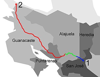
National Primary Route 1, formally known as Carretera Interamericana Norte, is the northern segment of the Pan-American Highway that traverses Costa Rica.

National Secondary Route 252, is an arterial road from Route 2 to Route 210 in Curridabat.

National Secondary Route 243, or just Route 243 is a National Road Route of Costa Rica, located in the San José, Puntarenas provinces. It connects Route 2 and Route 34.

<span class="mw-page-title-main">National Route 34 (Costa Rica)</span>

National Primary Route 34, official name Carretera Pacífica Fernández Oreamuno, and popularly known as Carretera Costanera Sur, or just Route 34, is a National Road Route and scenic route of Costa Rica, located in the Alajuela, Puntarenas provinces that connects Route 27 and Route 2 mostly along the central and south Pacific coast of the country, and is the recommended route over the Pan-American Highway when traveling between the south of the country to the Greater Metropolitan Area.

<span class="mw-page-title-main">Interurbano Line (Costa Rica)</span>

Interurbano Line, is a commuter railway line in Costa Rica, operated by the national public railway operator Incofer. The line connects the provinces of Alajuela, Heredia, San José and Cartago.

National Secondary Route 251, or just Route 251 is a National Road Route of Costa Rica, located in the San José, Cartago provinces.

National Secondary Route 222, or just Route 222 is a National Road Route of Costa Rica, located in the San José, Cartago provinces.

National Secondary Route 221, or just Route 221 is a National Road Route of Costa Rica, located in the San José, Cartago provinces.

References

  1. 1 2 Leandro, Harold (16 April 2017). "¿Cruzar el Cerro de la Muerte sin carro ni carretera? Los pioneros lo hicieron" . Retrieved 23 February 2020.
  2. "CarreteraInteramericanaen Costa Rica" (PDF). Ministerio de Obras Públicas y Transportes. Retrieved 23 February 2020.
  3. Rutkow, Eric. The Longest Line on the Map: The United States, the Pan-American Highway, and the Quest to Link the Americas. ISBN   1501103911.
  4. Schwartz, Max. "TBT: The birth of the Pan-American Highway".
  5. Recio, Patricia (15 May 2019). "MOPT planea construir rotonda cerca de Plaza del Sol y túnel en La Galera para agilizar tránsito en sector" . Retrieved 15 September 2019.
  6. "Arrancó proceso licitatorio para diseñar y construir túnel en la antigua Galera". Dirección de Relaciones Públicas. Retrieved 9 October 2019.
  7. Canales, Danny (14 September 2019). "Pasos elevados en Cartago iniciarán a mediados de 2020" . Retrieved 14 September 2019.
  8. Recio, Patricia (8 June 2019). "Constructora ofrece reducir a 30 minutos el viaje entre Cartago y San José" . Retrieved 24 September 2019.
  9. Recio, Patricia (24 September 2019). "Constructora MECO cerca del aval para ampliar vía a Cartago" . Retrieved 24 September 2019.
  10. "Colocación de base estabilizada entre El Empalme y Ojo de Agua alcanzó el 100%". ELPaís.cr. 15 October 2019. Retrieved 15 October 2019.
  11. Rojas, Pablo (10 November 2020). "Abren paso regulado en una de las 4 carreteras más afectadas por impactos de Eta". crhoy.com (in Spanish). Retrieved 19 November 2020.