An ecoregion is an ecologically and geographically defined area that is smaller than a bioregion, which in turn is smaller than a biogeographic realm. Ecoregions cover relatively large areas of land or water, and contain characteristic, geographically distinct assemblages of natural communities and species. The biodiversity of flora, fauna and ecosystems that characterise an ecoregion tends to be distinct from that of other ecoregions. In theory, biodiversity or conservation ecoregions are relatively large areas of land or water where the probability of encountering different species and communities at any given point remains relatively constant, within an acceptable range of variation . Ecoregions are also known as "ecozones", although that term may also refer to biogeographic realms.
In geography, regions, otherwise referred to as areas, zones, lands or territories, are portions of the Earth's surface that are broadly divided by physical characteristics, human impact characteristics, and the interaction of humanity and the environment. Geographic regions and sub-regions are mostly described by their imprecisely defined, and sometimes transitory boundaries, except in human geography, where jurisdiction areas such as national borders are defined in law. More confined or well bounded portions are called locations or places.
Pedology is a discipline within soil science which focuses on understanding and characterizing soil formation, evolution, and the theoretical frameworks for modeling soil bodies, often in the context of the natural environment. Pedology is often seen as one of two main branches of soil inquiry, the other being edaphology which is traditionally more agronomically oriented and focuses on how soil properties influence plant communities. In studying the fundamental phenomenology of soils, e.g. soil formation, pedologists pay particular attention to observing soil morphology and the geographic distributions of soils, and the placement of soil bodies into larger temporal and spatial contexts. In so doing, pedologists develop systems of soil classification, soil maps, and theories for characterizing temporal and spatial interrelations among soils. There are a few noteworthy sub-disciplines of pedology; namely pedometrics and soil geomorphology. Pedometrics focuses on the development of techniques for quantitative characterization of soils, especially for the purposes of mapping soil properties whereas soil geomorphology studies the interrelationships between geomorphic processes and soil formation.

Biogeography is the study of the distribution of species and ecosystems in geographic space and through geological time. Organisms and biological communities often vary in a regular fashion along geographic gradients of latitude, elevation, isolation and habitat area. Phytogeography is the branch of biogeography that studies the distribution of plants. Zoogeography is the branch that studies distribution of animals. Mycogeography is the branch that studies distribution of fungi, such as mushrooms.
Ecological classification or ecological typology is the classification of land or water into geographical units that represent variation in one or more ecological features. Traditional approaches focus on geology, topography, biogeography, soils, vegetation, climate conditions, living species, habitats, water resources, and sometimes also anthropic factors. Most approaches pursue the cartographical delineation or regionalisation of distinct areas for mapping and planning.

A bioregion is an ecologically and geographically defined area that is smaller than a biogeographic realm, but larger than an ecoregion or an ecosystem, and is defined along watershed and hydrological boundaries. People are counted as an integral part of the definition of a bioregion.
Regional geography is one of the major traditions of geography. It focuses on the interaction of different cultural and natural geofactors in a specific land or landscape, while its counterpart, systematic geography, concentrates on a specific geofactor at the global level.
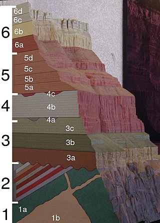
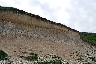
A geological formation, or simply formation, is a body of rock having a consistent set of physical characteristics (lithology) that distinguishes it from adjacent bodies of rock, and which occupies a particular position in the layers of rock exposed in a geographical region. It is the fundamental unit of lithostratigraphy, the study of strata or rock layers.

Terroir is a French term used to describe the environmental factors that affect a crop's phenotype, including unique environment contexts, farming practices and a crop's specific growth habitat. Collectively, these contextual characteristics are said to have a character; terroir also refers to this character.
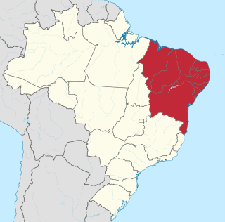
The Northeast Region of Brazil is one of the five official and political regions of the country according to the Brazilian Institute of Geography and Statistics. Of Brazil's twenty-six states, it comprises nine: Maranhão, Piauí, Ceará, Rio Grande do Norte, Paraíba, Pernambuco, Alagoas, Sergipe and Bahia, along with the Fernando de Noronha archipelago.

Brazil is geopolitically divided into five regions, by the Brazilian Institute of Geography and Statistics, which are formed by the federative units of Brazil. Although officially recognized, the division is merely academic, considering geographic, social and economic factors, among others, and has no political effects other than orientating Federal-level government programs. Under the state level, they are further divided into intermediate regions and even further into immediate regions.

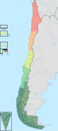
The Norte Grande is one of the five natural regions into which CORFO divided continental Chile in 1950. It borders Peru to the north, the Pacific Ocean to the west, the Altiplano, Bolivia and Argentina to the east, and the Copiapó River to the south, beyond which lies the Norte Chico natural region.

The Norte Chico region is one of five natural regions of continental Chile, as defined by the government agency CORFO in 1950. Its northern border is formed by the limit with the Far North, to the west lies the Pacific Ocean, to the east the Andes mountains and Argentina, and to the south the Zona Central natural region. Although from a strictly geographic point of view, this natural region corresponds to the Chilean territory between the rivers Copiapó and Aconcagua. Traditionally, the Norte Chico refers to the zone comprising the regions of Atacama and Coquimbo. This region was home to the Diaguita people.

Central Chile is one of the five natural regions into which CORFO divided continental Chile in 1950. It is home to a majority of the Chilean population and includes the three largest metropolitan areas—Santiago, Valparaíso, and Concepción. It extends from 32° south latitude to 37° south latitude.

Because Chile extends from a point about 625 kilometers north of the Tropic of Capricorn to a point hardly more than 1,400 kilometers north of the Antarctic Circle, within its territory can be found a broad selection of the Earth's climates.

The mainstream quality wine regions in Spain are referred to as denominaciones de origen protegidas (DOP) and the wine they produce is regulated for quality according to specific laws, and in compliance with European Commission Regulation (CE) 753/2002. In 2016, the use of the term Denominación de Origen (DO) was updated to Denominación de Origen Protegida (DOP) by the Spanish Ministry of Agriculture, Fisheries and Food ; the traditional term of DO can still be used legally on labels, but it will eventually be replaced by DOP.
Agriculture in Chile encompasses a wide range of different activities due to its particular geography, climate, geology and human factors. Historically agriculture is one of the bases of Chile's economy, now agriculture and allied sectors—like forestry, logging and fishing—account only for 4.9% of the GDP as of 2007 and employed 13.6% of the country's labor force. Some major agricultural products of Chile include grapes, apples, onions, wheat, corn, oats, peaches, garlic, asparagus, beans, beef, poultry, wool, fish and timber. Due to its geographical isolation and strict customs policies, Chile is free from diseases such as Mad Cow, fruit fly and Phylloxera, this plus being located in the southern hemisphere and its wide range of agriculture conditions are considered Chile's main comparative advantages. However, the mountainous landscape of Chile limits the extent and intensity of agriculture so that arable land corresponds only to 2.62% of the total territory.
The Protected areas of Portugal are classified under a legal protection statute that allows for the adequate protection and maintenance of biodiversity, while providing services for ecosystem that maintains the natural and geological patrimony.

The following outline is provided as an overview of and topical guide to geography:
This glossary of geography terms is a list of definitions of terms and concepts used in geography and related fields, including Earth science, oceanography, cartography, and human geography, as well as those describing spatial dimension, topographical features, natural resources, and the collection, analysis, and visualization of geographic data. It is split across two articles: