Natural regions of Germany

Last updated

Germany's major natural regions - Level 1: dark red, 2: orange, and 3: violet; major landscape unit groups: thin violet - based on the BfL classification Naturraeumliche Grossregionen Deutschlands plus.png
Germany's major natural regions - Level 1: dark red, 2: orange, and 3: violet; major landscape unit groups: thin violet - based on the BfL classification

This division of Germany into major natural regions takes account primarily of geomorphological, geological, hydrological, and pedological criteria in order to divide the country into large, physical units with a common geographical basis. Political boundaries play no part in this, apart from defining the national border.

Contents

In addition to a division of Germany by natural regions, the federal authorities have also produced a division by so-called landscape areas (Landschaftsräume) that is based more on human utilisation of various regions and so has clearly different boundaries.

Groundwork by the Federal Institute of Regional Studies (BfL)

The natural region classification of Germany, as used today by the Federal Office for Nature Conservation (Bundesamt für Naturschutz or BfN) and by most state institutions, is largely based on the work in producing the Handbook of Natural Region Divisions of Germany between the years 1953 to 1962. This divided the present federal territory (then West and East Germany) into 86 [1] so-called major landscape unit groups (Haupteinheitgruppen) each with a two-digit number between 01 and 90. These, in turn, were subdivided into up to ten, in some cases more, major landscape units (Haupteinheiten), each with a three-digit number. The handbook was accompanied by 1:100,000 scale mapping and, in the updated 1960 map, the major landscape unit groups were bundled together into major regions (Großregionen). [2] [3]

As a result, a regional classification of Germany emerged with five (since 1976: six) [3] primary landscape regions (naturräumliche Großregionen 1. Ordnung), divided into 18 (since 1964: 19) [3] secondary landscape regions (naturräumliche Großregionen 2. Ordnung). The major unit groups form, in effect, the third or tertiary level, [4] of landscape regions and the major units form the fourth level. Many secondary landscape regions only have one major unit group (Mecklenburg Coastal Lowland, Harz, Thuringian Basin, Upper Main-Upper Palatine Hills, Southern Alpine Foreland), others group well-known major regions together (Rhenish Massif, South German Scarplands); others are entirely new groupings.

In the subsequent work at 1:200,000 scale that lasted until the 1990s, that further split the landscape regions into a fifth and lower levels (using the three-digits numbers supplemented with further numbers placed after a decimal comma), it became apparent that the boundaries of major regions at the second and third levels had to be corrected in several places and, in individual cases, were no longer compatible with boundaries of the major unit groups. [3] This has no impact on the numbering system of the lower levels, however.

New Classification by the Federal Office for Nature Conservation (BfN)

From 1992 to 1994, Axel Ssymank revised the major unit groups 01-90 under the direction of the BfN. Most groups retained their boundaries, however, in some cases two to four major units groups according to the handbook were combined, whilst in the North and Baltic Seas, one old group was divided into four new ones.

The numbering of the new units, D01 to D73, is entirely new and runs from north to south not, as in the handbook, from south to north. So it is not compatible with the numbers of the main and subordinate landscape units, which is why it has not been adopted by the state institutions. Even the BfN has largely followed the older system in the handbook in its landscape fact files (Landschaftssteckbriefe). [5]

Ssymank combined the natural regions into eight so-called great landscapes (Großlandschaften), which are rather less finely divided than the secondary main regions (Großregionen 2. Ordnung) of the BfL. The only discrepancy between the two systems is the division of the North German Plain into western and eastern parts, which is based on their climatic division into Atlantic and Continental areas. The boundary runs randomly east of landscape units D22, D24, D28, D31, and D33. These great landscape definitions have yet to be used in the literature.

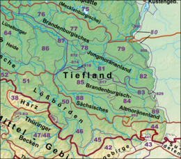
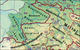
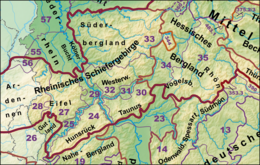
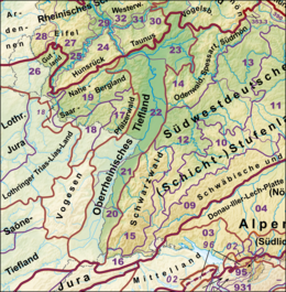
List of major landscape regions - levels 1 to 3

Germany can be divided into three major geographical regions: the Northern Lowland or North German Plain, the Central Uplands, and the Alps running roughly west to east across the country. [6]

The official major landscape groups, which more or less correspond to the tertiary level [4] of major landscape regions, are grouped following the primary and secondary landscape region system. These subdivisions largely correspond to the publications of the Institute for Regional Studies (BfL) since 1960 which are:

For clarity the first and second levels of the major landscape regions are organised from north to south and from west to east. Within a secondary or tertiary landscape region the list follows the numerical order in the handbook; the BfN's numbers are given in brackets. Tertiary major landscape regions are shown in bold italics. Maps, all to the same scale, are shown to the right of the lists.

For clarity, the English names for the natural regions are given; German names may be found at the relevant article. The English names are primarily based on Dickinson (1964) [8] and Elkins (1972) [6] where their classification corresponds closely to the handbook's. In such cases the source of the English name is referenced.

The seven major regions are: the Northeast German Plain, the Northwest German Plain, the Western Central Uplands, the Eastern Central Uplands, the South German Scarplands, [6] [8] the Alpine Foreland, and the North and Baltic Seas.


North and Baltic Seas

This is a list, exceptionally, of the three-figure major landscape units of group 90, because this de facto corresponds to the tertiary major landscape regions.

North Sea

Haupteinheitengruppen Nordsee und Marschen.png

Baltic Sea

North German Plain

Marshland [7]

Mecklenburg-Western Pomeranian Littoral

Haupteinheitengruppen Ostsee und Seenplatte.png
  • 71 Mecklenburg-Western Pomeranian Littoral [6] (D01)

Mecklenburg Coastal Lowland [6] [7]

Haupteinheitengruppen Tiefland Westteil.png

Central North German Plain [7]

Haupteinheitengruppen Tiefland Ostteil und Loessboerden.png

Loess Belt [6] [7]

Haupteinheitengruppen Tiefland Ostteil und Loessboerden.png

Central Uplands [7]

Rhenish Massif

Haupteinheitengruppen Rheinisches Schiefergebirge.png

Arranged from west to east and internally from north to south)

Weser Uplands and Hesse Lowlands and Highlands [7]

Haupteinheitengruppen noerdliche Mittelgebirge.png

(arranged from north to south and from west to east)

Harz

Thuringian Basin

Haupteinheitengruppen oestliche Mittelgebirge.png

Eastern Central Uplands [7]

Scarplands on either side of the Upper Rhine Valley [7]

Palatine-Saarland Scarplands

Haupteinheitengruppen westliches Schichtstufenland.png

Division from north to south and from west to east

Upper Rhine Plain

Haupteinheitengruppen Suedwestdeutsches Stufenland.png

Divided from north to south.

South German Scarplands [6] [8]

(arranged by escarpments Grundgebirge/Buntsandstein, Muschelkalk, Keuper-Lias and Malm from north to south, internally from west to east.

Upper Palatine-Upper Main Hills

Alpine Foreland [6]

arranged from north to south and from west to east)

Northern Alpine Foreland

This map does not show the latest situation and still combines under 02 landscape units that mainly belong to the Alps. Haupteinheitengruppen Alpenvorland und Alpen.png
This map does not show the latest situation and still combines under 02 landscape units that mainly belong to the Alps.

Southern Alpine Foreland

  • Pre-Alpine Hills and Moorland (= Southern Alpine Foreland; D66)
    • 03 Subalpine New Moraine Land
    • 02* [13] Nagelfluh Hills and Basins between Lake Constance and Wertach

Alps

The following 3 groups were still counted as part of (ex-)group 02 in the Handbook; the German sections form D67 (BfN).

Nagelfluh Mountains of the Appenzell Alps

The two Nagelfluh groups (02 and 96) are located in the west of the map extract on the boundary between the Alpine Foreland and the Alps Haupteinheitengruppen Alpenvorland und Alpen.png
The two Nagelfluh groups (02 and 96) are located in the west of the map extract on the boundary between the Alpine Foreland and the Alps
  • (to 02 Nagelfluh Hills and Basins – Alpine Foreland)
    • Molasse Ridges of St. Gallen–Appenzell (northeast of St. Peterzell 1170 m; CH)
  • (to 96 Swiss and Allgäu Nagelfluh Ridges)

Lower Bregenz Forest

  • (to 02 Nagelfluh Hills and Basins – Alpine Foreland)
    • 020 Pfänder (Hirschberg 1,095 m; D and A)
    • 021.0–5 with 021.2 Sulzberg (1,041 m; A)
  • (to 96 Swiss and Allgäu Nagelfluh Ridges)

Swabian-Bavarian Pre-alps

  • (to 90 Basins and valleys between the main Alpine groups)
    • (to 900 Basins and valleys in the western Vorarlberg-Allgäu Alps)
    • (to 902 Inn Valley)
      • 902.4 Basins of Kiefer Fields and Inn Valley
    • 908 Inzell Basin
The major landscape region is located in the centre on the northern edge of the Alps, its southern section is part of the Intermediate Limestone Alps (935); in the unlabelled segments is a combination of the Flysch Alps (94) and foothill chains (936) with basins (908, 930). Haupteinheitengruppen Alpenvorland und Alpen.png
The major landscape region is located in the centre on the northern edge of the Alps, its southern section is part of the Intermediate Limestone Alps (935); in the unlabelled segments is a combination of the Flysch Alps (94) and foothill chains (936) with basins (908, 930).
  • (to93 Northern Limestone Eastern Alps)
    • (930 Basins and valleys between the main groups of the Northern Limestone Eastern Alps (part))
    • 935 Bavarian-Tyrolean Intermediate Limestone Alps (less 935.7)
    • 936 Border mountains of the Northern Limestone-Eastern Alps or Limestone Alp Border Mountains or Limestone Border Mountains
  • (to 94 Flysch Alps)
    • (to 941 East Allgäu Flysch Alps)
      • 941.1 Mountains around the Wertacher Hörnle
      • 941.2 Bayerstädter Kopf-Alpspitz-Edelsberg Group
    • 942 Trauchgau-Murnau (Ammergau) Flysch Alps
    • 943 Tölz-Tegernsee-Chiemgau Flysch Alps
    • 944 Western Salzburg Flysch Alps
  • (to 95 Northern Limestone Western Alps)
    • (to 950 Vorarlberg-Allgäu Quintner and Schrattenkalkgewölbe)

Austrian Pre-Alps

Only the western end of the group, which lies entirely in Austria, was studied.

Northern Limestone Alps (west)

The following group was counted as (ex-)group 01 in the Handbook; the German parts near Oberstdorf and Garmisch-Partenkirchen belong to D68 (BfN).

  • (to 90 Basins and valleys between the main Alpine groups)
    • Rhine Valley
    • Ill tal
    • 900 Basins and valleys in the western part of the Vorarlberg-Allgäu Alps
    • 901 Oberstdorf Basin and side valleys (Illertal and Basins and valleys in the eastern part of the Vorarlberg-Allgäu Alps)
    • 902 Inn Valley (less 902.4)
The main part of the major landscape region (centre and west, below) consists of the major landscape units 931 to 933 and, in the west, parts of 95. Haupteinheitengruppen Alpenvorland und Alpen.png
The main part of the major landscape region (centre and west, below) consists of the major landscape units 931 to 933 and, in the west, parts of 95.
  • (to 93 Northern Limestone Eastern Alps)
    • 930 Basins and valleys between the main groups of the Northern Limestone Eastern Alps (partly)
    • 931 Allgäu Alps
    • 932 Lechtal Alps
    • 933 Inn Valley Riffkalkketten (less 333.7)
  • (to 94 Flysch Alps)
    • 940 Vorarlberg and West Allgäu Flysch Alps
    • (to 941 East Allgäu Flysch Alps)
  • (to 95 Northern Limestone Western Alps)
    • Alpstein Group (up to 2,502 m)
    • Rätikon (up to 2,964 m)
    • 950 Vorarlberg-Allgäu Quintner and Schrattenkalkgewölbe (less 950.0)

Northern Limestone Alps (east)

The following group was counted as part of (ex-)group 01 in the Handbook; the German parts near Berchtesgaden belong accordingly to D68 (BfN).

Most of the group lies in Austria.

The main part of the major landscape region (southern east part of the extract) consists of major landscape uunit 934 and, in the west, of parts of 933 and 935. Haupteinheitengruppen Alpenvorland und Alpen.png
The main part of the major landscape region (southern east part of the extract) consists of major landscape uunit 934 and, in the west, of parts of 933 and 935.
  • 93 Northern Limestone Eastern Alps
    • 930 Basins and valleys between the main groups of the Northern Limestone Eastern Alps(in places)

(to 933 Inn Valley Riffkalkketten)

Central Alps

The Central Alps lies completely outside of Germany and are only mapped at the fringes.

  • 91 Eastern Central Alps
  • 92 Slate Alps of the Northern Greywacke Zone

See also

Related Research Articles

<span class="mw-page-title-main">Outer Subcarpathia</span>

Outer Subcarpathia denotes the depression area at the outer base of the Carpathian arc, including foothills of the Outer Western Carpathians and Outer Eastern Carpathians. It stretches from northeastern Austria, through eastern Czech Republic, southern Poland, western Ukraine and northeastern Romania.

<span class="mw-page-title-main">Central Eastern Alps</span> Portion of the Eastern Alps mountain range through Austria and parts of surrounding countries

The Central Eastern Alps, also referred to as Austrian Central Alps or just Central Alps, comprise the main chain of the Eastern Alps in Austria and the adjacent regions of Switzerland, Liechtenstein, Italy and Slovenia. South them is the Southern Limestone Alps.

<span class="mw-page-title-main">Allgäu Alps</span> Mountain range in the Northern Limestone Alps

The Allgäu Alps are a mountain range in the Northern Limestone Alps, located in Bavaria and Baden-Württemberg in Germany and Tyrol and Vorarlberg in Austria. The range lies directly east of Lake Constance.

<span class="mw-page-title-main">North German Plain</span> Plain in Germany

The North German Plain or Northern Lowland is one of the major geographical regions of Germany. It is the German part of the North European Plain. The region is bounded by the coasts of the North Sea and the Baltic Sea to the north, Germany's Central Uplands to the south, by the Netherlands to the west and Poland to the east.

<span class="mw-page-title-main">Alpine Foreland</span> Geographic region, Southern Germany

The Alpine Foreland, less commonly called the Bavarian Foreland, Bavarian Plateau or Bavarian Alpine Foreland, refers to a triangular region of plateau and rolling foothills in Southern Germany, stretching from Lake Constance in the west to beyond Linz on the Danube in the east, with the Bavarian Alps forming its south boundary and the Danube its northern extent.

The Saxon Loess Fields refer to a natural region that lies mainly within the state of Saxony in central Germany. In addition, small areas of this region extend to the northwest and west into Saxony-Anhalt, to the southeast into Thuringia and to the northeast into Brandenburg. It more-or-less combines the BfN's major regions listed as D19 Saxon Upland and Ore Mountain Foreland, and D14, Upper Lusatia (Oberlausitz); only the range of Central Uplands hills, the Lusatian Mountains, has been excluded and instead forms part of the Saxon Highlands and Uplands.

<span class="mw-page-title-main">West Hesse Highlands</span>

The West Hesse Highlands, also known as the West Hessian Lowlands and Highlands, are a heavily forested region of the Central Uplands in Germany. These highlands lie mainly within the state of Hesse, between that part of the Rhenish Massif right of the Rhine in the west, the Weser Uplands to the north, the Hessian Central Uplands to the east and the Wetterau to the south.

<span class="mw-page-title-main">West Hesse Depression</span>

The West Hesse Depression is part of the West Hesse Highlands and Lowlands region in the north of the German state of Hesse. Like the East Hesse Depression, it is a series of separate depressions that form a natural corridor and have been an important historical trade route.

The East Hesse Highlands describes a heavily wooded range of hills lying mainly in the German state of Hesse, but also extending a little way into Lower Saxony to the north, Thuringia to the east and Bavaria to the southeast. The region is sandwiched between the West Hesse Depression to the west, the Weser Uplands to the north, the Thuringian Basin to the northeast, the northwestern edge of the Thuringian Forest to the east, the Spessart to the south and the Wetterau to the southwest.

The Saxon Highlands and Uplands refer to a natural region mainly in the south of Saxony with small elements also in southeast Thuringia and northeast Bavaria. It comprises, from (south)west to (north)east, of the Vogtland, the Ore Mountains, Saxon Switzerland, the Upper Lusatian Plateau and the Zittau Hills.

<span class="mw-page-title-main">Gäu Plateaus</span> Largest natural region in Baden-Württemberg, Germany

The Gäu Plateaus form the largest natural region in the German state of Baden-Württemberg. Not surprisingly, the individual geographical units of this large region show considerable variations in climate and soil types. A common feature of the region, however, is its landscape of flat-topped hills of Muschelkalk, gently rolling tracts of loess and plateaus in which the layers of Muschelkalk have been covered by sediments of Gipskeuper and Lettenkeuper.

<span class="mw-page-title-main">Leine Uplands</span>

The Leine Uplands is a region in Germany's Central Uplands which forms a part of the Lower Saxon Hills and lies along the River Leine between Göttingen and Hanover. It borders on the Weser Uplands in the west, the Innerste Uplands in the northeast, the Harz in the east and Untereichsfeld in the southeast.

<span class="mw-page-title-main">Ammergau Alps</span>

The Ammergau Alps are a mountain range in the Northern Limestone Alps in the states of Bavaria (Germany) and Tyrol (Austria). They cover an area of about 30 x 30 km and begin at the outer edge of the Alps. The highest summit is the Daniel which has a height of 2,340 metres (7,680 ft).

The Franconian Keuper-Lias Plains or Franconian Keuper-Lias Lands are a major natural region in the South German Scarplands in Upper Franconia and to a lesser extent in the north, in the Thuringian district of Hildburghausen. As the name indicates, the term embraces both the Keuper landscapes and lias landscapes in Franconia. In addition, the fore-land of the Franconian Jura, in which part of the Brown Jurassic occurs, as well as parts of the former volcanic region of Heldburger Gangschar belong to this region.

The Dümmer Geest Lowland is a natural region unit of the 3rd level in northwest Germany that mainly extends over southwestern Lower Saxony with a small area over the border in North Rhine-Westphalia. Its uniqueness consists in the very varied juxtaposition of different landscape elements of the Northern Lowlands of which the Dümmer Geest Lowland is a part.

<span class="mw-page-title-main">Upper Hessian Ridge</span> Hill chain in Germany

The Upper Hessian Ridge or Upper Hesse Ridge is a hill chain in the West Hesse Highlands in North and Middle Hesse, which lies on the Rhine-Weser watershed and links the montane Central Upland ranges of the Kellerwald and the Vogelsberg in a north-south direction. The swell is divided into the Gilserberg Heights in the north, the central Neustadt Saddle and the Northern Vogelsberg Foreland in the south.

<span class="mw-page-title-main">Geology of Germany</span> Overview of the geology of Germany

The geology of Germany is heavily influenced by several phases of orogeny in the Paleozoic and the Cenozoic, by sedimentation in shelf seas and epicontinental seas and on plains in the Permian and Mesozoic as well as by the Quaternary glaciations.

The Weser-Aller Plains and Geest is a natural regional unit of the North German Plain in Germany. It extends over most of the southern catchment of the Aller including the lower reaches of the Oker and Leine and is bounded in the west by the Middle Weser.

In terms of geomorphological division, the Czech Republic is a very diverse territory, located in the territory of four geomorphological provinces within four geomorphological subsystems. The Bohemian Massif within the sub-system of Hercynian Forest forms three quarters of the country. The southeastern and eastern part of the Czech territory belongs to the Western Carpathians within the Carpathian Mountains. The remaining two provinces, Western Pannonian Basin within the Pannonian Basin and North European Plain within the European Plain, cover only a small part of the Czech territory in the southeast and the northeast.

References

  1. whilst the regions were numbered 01-90, there were only 86 in toto because nos. 47/48 were used for a single group and the numbers 49, 65 and 66 were unused.
  2. E. Meynen and J. Schmithüsen: Handbuch der naturräumlichen Gliederung Deutschlands – Bundesanstalt für Landeskunde, Remagen/Bad Godesberg 1953-1962 (9 editions in 8 books, updated 1960 1:1,000,000 map with major units)
  3. 1 2 3 4 5 6 7 Naturräumliche Großregionenkarten 1960–1963, 1964–1978 und 1979–1994 nach Müller-Miny et al. (pdf, 1.2 MB)
  4. 1 2 However, in some instances, the third level landscape regions combine several groups together.
  5. Biogeografische Regionen und naturräumliche Haupteinheiten Deutschlands (pdf, 216 kB) by Ssymank (1994), Übersicht und Kommentar; Bundesamt für Naturschutz. Caution: in the document the term major units (Haupteinheiten) is incorrectly used to refer to major unit groups (Haupteinheitengruppen, in the sense of the Institute for Regional Studies)!
  6. 1 2 3 4 5 6 7 8 9 10 11 12 13 14 15 16 17 18 19 20 21 22 23 24 25 26 27 28 29 30 31 32 33 34 35 36 Elkins (1972).
  7. 1 2 3 4 5 6 7 8 9 10 11 12 13 14 15 16 17 18 19 20 A more precise name of this secondary or tertiary major landscape region is not recorded (in German or English).
  8. 1 2 3 4 5 6 7 8 9 10 11 12 13 14 15 16 17 18 19 20 21 22 23 24 25 26 27 28 29 30 31 32 33 34 35 36 37 38 39 40 41 42 43 44 45 46 47 48 49 50 51 52 53 54 55 56 57 58 Dickinson (1964).
  9. 1 2 3 4 5 Kohl, Marcinek and Nitz (1986), p. 34.
  10. Ohorn at zip-code.en. Retrieved 12 Oct 2013
  11. Enter the Past: The E-way Into the Four Dimensions of Cultural Heritage : CAA 2003, Computer Applications and Quantitative Methods in Archaeology p. 267; Proceedings of the 31st Conference, Archaeopress, Vienna, Austria, April 2003.
  12. Kohl, Marcinek and Nitz (1986), p. 35
  13. this group was first created in 1991 and is different from the old group 02, see #Classification by Dongus and Hormann
  14. Blatt Salzburg reicht nur bis 937.1 Osterhorngruppe, daher hat Homann die Benennung der Haupteinheit späteren Bearbeitern in Österreich anheimgestellt.

Sources