
The Hopewell tradition describes the common aspects of an ancient pre-Columbian Native American civilization that flourished in settlements along rivers in the northeastern and midwestern Eastern Woodlands from 100 BCE to 500 CE, in the Middle Woodland period. The Hopewell tradition was not a single culture or society, but a widely dispersed set of populations connected by a common network of trade routes. This is known as the Hopewell exchange system.

The Liangzhu culture was the last Neolithic jade culture in the Yangtze River Delta of China. The culture was highly stratified, as jade, silk, ivory and lacquer artifacts were found exclusively in elite burials, while pottery was more commonly found in the burial plots of poorer individuals. This division of class indicates that the Liangzhu period was an early state, symbolized by the clear distinction drawn between social classes in funeral structures. A pan-regional urban center had emerged at the Liangzhu city-site and elite groups from this site presided over the local centers. The Liangzhu culture was extremely influential and its sphere of influence reached as far north as Shanxi and as far south as Guangdong. The primary Liangzhu site was perhaps among the oldest Neolithic sites in East Asia that would be considered a state society. The type site at Liangzhu was discovered in Yuhang County, Zhejiang and initially excavated by Shi Xingeng in 1936. A 2007 analysis of the DNA recovered from human remains shows high frequencies of Haplogroup O1 in Liangzhu culture linking this culture to modern Austronesian and Tai-Kadai populations. It is believed that the Liangzhu culture or other associated subtraditions are the ancestral homeland of Austronesian speakers.

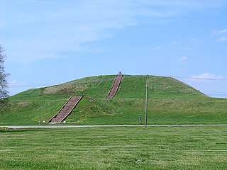
Etowah Indian Mounds (9BR1) are a 54-acre (220,000 m2) archaeological site in Bartow County, Georgia, south of Cartersville. Built and occupied in three phases, from 1000–1550 AD, the prehistoric site is located on the north shore of the Etowah River.

Fort Ancient is a name for a Native American culture that flourished from Ca. 1000-1750 CE and predominantly inhabited land near the Ohio River valley in the areas of modern-day southern Ohio, northern Kentucky, southeastern Indiana and western West Virginia. Although a contemporary of the Mississippian Culture, they are often considered a "sister culture" and distinguished from the Mississippian Culture. Although far from agreed upon, there is evidence to suggest that the Fort Ancient Culture were not the direct descendants of the Hopewellian Culture. It is suspected that the Fort Ancient Culture introduced maize agriculture to Ohio. The Fort Ancient Culture were most likely the builders of the Great Serpent Mound.
A number of pre-Columbian cultures are collectively termed "Mound Builders". The term does not refer to a specific people or archaeological culture, but refers to the characteristic mound earthworks erected for an extended period of more than 5,000 years. The "Mound Builder" cultures span the period of roughly 3500 BCE to the 16th century CE, including the Archaic period, Woodland period, and Mississippian period. Geographically, the cultures were present in the region of the Great Lakes, the Ohio River Valley, and the Mississippi River valley and its tributary waters.
Spiro Mounds is an archaeological site located in present-day eastern Oklahoma that remains from an indigenous Indian culture that was part of the major northern Caddoan Mississippian culture. The 80-acre site is located within a floodplain on the southern side of the Arkansas River. The modern town of Spiro developed approximately seven miles to the south.
The Big Eddy Site (23CE426) is an archaeological site located in Cedar County, Missouri, which was first excavated in 1997 and is now threatened due to erosion by the Sac River.
The Steed-Kisker culture is a cultural phase that is part of the larger Central Plains Village tradition of the Plains Village period. This term applies to the prehistoric peoples who occupied the Great Plains region of the modern-day United States in prehistoric times.
The Spartia temple is an ancient Greek cult site excavated at the foot of the hill of Spartia, north of the village of Sesklo, in the Magnesia regional unit. An inscribed dedication suggests the worship there of the Greek mythological figures Heracles and Alcmene.

The Eva site (40BN12) is a prehistoric Native American site in Benton County, Tennessee, in the Southeastern United States. Located along an ancient channel of the Tennessee River, the Eva site saw extensive periods of occupation during the Middle and Late Archaic period. The site's well-defined midden layers helped investigators identify three distinct Archaic cultures, the oldest of which was first identified at Eva and is still known as the "Eva culture" or the "Eva phase."

The archaeology of Iowa is the study of the buried remains of human culture within the U.S. state of Iowa from the earliest prehistoric through the late historic periods. When the American Indians first arrived in what is now Iowa more than 13,000 years ago, they were hunters and gatherers living in a Pleistocene glacial landscape. By the time European explorers visited Iowa, American Indians were largely settled farmers with complex economic, social, and political systems. This transformation happened gradually. During the Archaic period American Indians adapted to local environments and ecosystems, slowly becoming more sedentary as populations increased. More than 3,000 years ago, during the Late Archaic period, American Indians in Iowa began utilizing domesticated plants. The subsequent Woodland period saw an increase on the reliance on agriculture and social complexity, with increased use of mounds, ceramics, and specialized subsistence. During the Late Prehistoric period increased use of maize and social changes led to social flourishing and nucleated settlements. The arrival of European trade goods and diseases in the Protohistoric period led to dramatic population shifts and economic and social upheaval, with the arrival of new tribes and early European explorers and traders. During the Historical period European traders and American Indians in Iowa gave way to American settlers and Iowa was transformed into an agricultural state.

Prehistory of Ohio provides an overview of the activities that occurred prior to Ohio's recorded history. The ancient hunters, Paleo-Indians, descended from humans that crossed the Bering Strait. There is evidence of Paleo-Indians in Ohio, who were hunter-gatherers that ranged widely over land to hunt large game. For instance, mastodon bones were found at the Burning Tree Mastodon site that showed that it had been butchered. Clovis points have been found that indicate interaction with other groups and hunted large game. The Paleo Crossing Site and [[Nobles Pond Site Tools, like spear-throwers, were more sophisticated. Base camps were established for winter lodging. The Glacial Kame culture, a late Archaic group, traded for sea shell and copper with other groups and were used as a sign of prestige within the group, for respected healers and hunters. The objects were buried with their owners.

The Kansas City Hopewell were the farthest west regional variation of the Hopewell tradition of the Middle Woodland period. Sites were located in Kansas and Missouri around the mouth of the Kansas River where it enters the Missouri River. There are 30 recorded Kansas City Hopewell sites.
The Renner Village Archeological Site (23PL1) is a prehistoric archaeological site located in the municipality of Riverside, Platte County, Missouri. It was a village site inhabited from approximately 1 CE to 500 CE by peoples of the Kansas City Hopewell culture and through the Woodland period to 1200 CE by peoples of the Middle Mississippian culture. It was added to the National Historic Register on April 16, 1969.

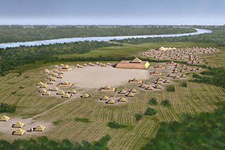
Poverty Point State Historic Site/Poverty Point National Monument is a prehistoric earthwork constructed by the Poverty Point culture. The Poverty Point site is located in present-day northeastern Louisiana though evidence of the Poverty Point culture extends throughout much of the Southeastern Woodlands. The culture extended 100 miles (160 km) across the Mississippi Delta and south to the Gulf Coast. The Poverty Point site has been designated as a state historic site, U.S. National Monument, a U.S. National Historic Landmark, and UNESCO World Heritage Site. Located in the Southern United States, the site is 15.5 miles (24.9 km) from the current flow of the Mississippi River, and is situated on the edge of Macon Ridge, near the village of Epps in West Carroll Parish, Louisiana.

Franktown Cave is located 25 miles south of Denver, Colorado on the north edge of the Palmer Divide. It is the largest rock shelter documented on the Palmer Divide, which contains artifacts from many prehistoric cultures. Prehistoric hunter-gatherers occupied Franktown Cave intermittently for 8000 years beginning about 6400 B.C. The site held remarkable lithic and ceramic artifacts, but it is better known for its perishable artifacts, including animal hides, wood, fiber and corn. Material goods were produced for their comfort, task-simplification and religious celebration. There is evidence of the site being a campsite or dwelling as recent as AD 1725.

Mississippian copper plates, or plaques, are plain and repousséd plates of beaten copper crafted by peoples of the various regional expressions of the Mississippian culture between 800 and 1600 CE. They have been found as artifacts in archaeological sites in the American Midwest and Southeast. The plates, found as far afield as Florida, Georgia, Illinois, Mississippi, Oklahoma, Tennessee, and Wisconsin, were instrumental in the development of the archaeological concept known as the Southeastern Ceremonial Complex. Some of the more notable examples are representations of raptorial birds and avian-themed dancing warriors.
The Emmons Cemetery Site, also known as the Emmons Site, is a Middle Mississippian culture archaeological site located in Kerton Township, Fulton County, Illinois, on the edge of a bluff overlooking the Illinois River to its east. The location was a used as a cemetery and several unique and rare items were found interred with the burials.
Humans have been present in the Canadian Maritime provinces for 10,600 years. In spite of being the first part of Canada to be settled by Europeans, research into the prehistory of the Maritimes did not become extensive until 1969. By the early 1980s, several full-time archaeologists focused on the region.


