
Long Beach, California, is composed of many different neighborhoods. Some neighborhoods are named after thoroughfares, while others are named for nearby parks, schools, or city features.
Long Beach, California, is composed of many different neighborhoods. Some neighborhoods are named after thoroughfares, while others are named for nearby parks, schools, or city features.
[ [1]

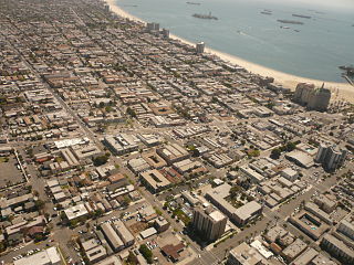
Long Beach is a city in Los Angeles County, California. It is the 42nd-most populous city in the United States, with a population of 466,742 as of 2020. A charter city, Long Beach is the seventh-most populous city in California.
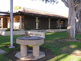
Los Alamitos is a city in Orange County, California. The city was incorporated in March 1960. The population was 11,780 at the 2020 census, up from 11,449 at the 2010 census. The adjacent unincorporated community of Rossmoor uses the same 90720 ZIP code in its mailing address, but is not part of the city. The Los Alamitos Race Course is named for the city, but lies in the neighboring city of Cypress.

Shoreline is a city in King County, Washington, United States. It is located between the city limits of Seattle and the Snohomish County border, approximately 9 miles (14 km) north of Downtown Seattle. As of the 2020 census, the population of Shoreline was 58,608, making it the 22nd largest city in the state. Based on per capita income, one of the more reliable measures of affluence, Shoreline ranks 91st of 522 areas in the state of Washington to be ranked.

The Scarborough Bluffs, also known as The Bluffs, is an escarpment in the Scarborough district of Toronto, Ontario, Canada. There are nine parks along the bluffs, with Bluffers Park being the only one with a beach. Forming much of the eastern portion of Toronto's waterfront, the Scarborough Bluffs stands above the shoreline of Lake Ontario. At its highest point, the escarpment rises 90 metres (300 ft) above the coastline and spans a length of 15 kilometres (9.3 mi).

Downtown Long Beach is the heart of Long Beach, California, United States, and is the location for most of the city's major tourist attractions and municipal services. It is also the location for numerous businesses. There are many hotels and restaurants in the area that serve locals, tourists, and convention visitors.

Bluff Park is a small, upscale neighborhood in Long Beach, California, United States. There is a bluff along much of the beach in Long Beach, and on one stretch, there is the narrow Bluff Park from which the neighborhood gets its name.

El Dorado Regional Park is a park in Long Beach, California. It is on the east side of the city.

Wrigley is a group of neighborhoods in Long Beach, California. It includes the neighborhoods North Wrigley, South Wrigley, Southeast Wrigley and Wrigley Heights. Its name derives from William Wrigley Jr., the owner and founder of the famed Wrigley Spearmint Gum Empire in Chicago. It was one of the first communities established in Long Beach. With the exception of Wrigley Heights, the area is developed throughout on a gridiron street pattern.
Bixby Knolls is a neighborhood in Long Beach, California, named after the Bixby family.

The Cove is a neighborhood located in the southeast corner of Stamford, Connecticut. It is an area of mostly modest homes with some very expensive homes along the shoreline.
Miller/Knox Regional Shoreline is a 295-acre (1.19 km2) bayside park near the Brickyard Cove neighborhood of the Point Richmond District in Richmond, California.
California Heights is a historic neighborhood of Long Beach, California.

The Long Beach Police Department provides law enforcement for the city of Long Beach, California.
Alamitos Beach is a coastal neighborhood in the southern portion of the city of Long Beach, California. Although it was in unincorporated Los Angeles County when annexed by the City of Long Beach, it had been planned as its own community with a townsite.
Alamitos Heights is a neighborhood in the south-east portion of the city of Long Beach, California, United States.
The Bixby family is an American family that was heavily involved in the development of California ranches and real estate in the 19th and 20th centuries. Through various companies, they controlled at one time or another large swathes of California real estate, much of it derived from Mexican land grants. Over several generations, their holdings included Rancho Los Cerritos and Rancho Los Alamitos, and parts of Rancho San Justo and Rancho Palos Verdes, totaling well over 100,000 acres. Parts of the towns of Long Beach, Bellflower, Paramount, Signal Hill, Lakewood, and Los Alamitos emerged from former Bixby-held lands. Within Long Beach, the neighborhoods Bixby Hill, Bixby Knolls, and Bixby Village are named after the family, as well as Bixby Park in the Alamitos Beach neighborhood.