Neolithic and Bronze Age rock art in the British Isles

Last updated

Typical cup and ring marks at Weetwood Moor, in the English county of Northumberland Cup and ring marks.jpg
Typical cup and ring marks at Weetwood Moor, in the English county of Northumberland
A replica of an unusual cup-and-ring-marked stone from Dalgarven, North Ayrshire, Scotland. Cupandring.JPG
A replica of an unusual cup-and-ring-marked stone from Dalgarven, North Ayrshire, Scotland.

In the Neolithic and Bronze Age British Isles, rock art was produced across various parts of the islands. Petroglyphic in nature, the majority of such carvings are abstract in design, usually cup and ring marks, although examples of spirals or figurative depictions of weaponry are also known. Only one form of rock art in Europe, this late prehistoric tradition had connections with others along Atlantic Europe, particularly in Galicia.

Contents

The study of rock art in the British Isles was largely initiated by amateur researchers rather than academic or other professional archaeologists.

Surviving examples of rock art in the British Isles are believed to represent only a small sample of that which had been produced in the Neolithic and Bronze Ages. Many examples of petroglyphs would have eroded away, thereby being lost to contemporary scholarship. [1] In other examples, images might have been painted onto rock, or marked onto less permanent surfaces, such as wood, livestock or the human body, thereby also failing to survive into the present. [1]

Chronology

Rock art had first appeared in Atlantic Europe by the late fourth millennium BCE. [2] In Britain, rock art had ceased by the time of the agricultural intensification in the Late Bronze Age, the first millennium BCE. [2]

Distribution

Northern Britain

Within Britain, the majority of recorded Neolithic and Bronze Age rock art comes from the northern part of the island. [3] [4] Cup-and-ring marks are particularly common in this area. [5]

Cup-and-ring marks are usually attributed to the Neolithic and Early Bronze Ages, [6] while attempts at building a relative chronology have been tried in Dumbartonshire. [7]

South West Britain

Over 70 examples of late prehistoric rock art have been identified in the South West of Britain, [4] being far sparser than those found in the North. [8] This may in part be due to the harder nature of the natural rock in the area, which is largely plutonic granite, alongside a lack of research focused in this region. [4] Rock art specialist George Nash considered the petroglyphs of this region to constitute a distinct artistic tradition from that in the North. [4] The majority of petroglyphs in South West Britain are cup marks, engraved both onto the rock face and on boulders, as at the Castallack Menhir. [9]

One of the Rocky Valley labyrinths. Rockyvalleycarving2.JPG
One of the Rocky Valley labyrinths.

Archaeologists are aware of three instances in South West Britain where weapons are depicted in petroglyphs: at Boscawen-un stone circle in Cornwall, at Badbury Rings Barrow in Dorset, and at Stonehenge in Wiltshire. [10] Using relative dating, the weapons depicted on Boscawen-un have been tentatively dated to circa 2000 BCE, while those at Badbury Rings and Stonehenge have been dated to c. 1800 BCE. [11]

Several petroglyphic labyrinths have also been discovered in South West Britain. The best known of these are a neighbouring pair that have been found engraved onto a shale outcrop at Rocky Valley, Cornwall. [12] Apparently incised using a metal implement, Nash suggested that the southern labyrinth had previously been engraved using a stone tool. [12] Publicly revealed in 1948, [13] it has been suggested that they are Bronze Age in date, due to similarities with Bronze Age petroglyphs in Galicia and Valcamonica. [14] Conversely, many rock art researchers do not consider them to be prehistoric, with Saward arguing that they were created between the 16th and 18th-centuries, when the neighbouring Trewethett Mill was operational. As evidence, she noted that labyrinths were a popular motif in folk customs at the time, and that the good state of preservation would not be present if they had prehistoric origins. [13]

Ireland

Engravings at the entrance to Newgrange. Newgrange, Ireland.jpg
Engravings at the entrance to Newgrange.

Cup-and-ring marks are particularly common in this area. [5] The greatest concentrations of open-air rock art occur in Fermnanagh/Donegal, Wicklow/Carlow, Louth/Monaghan, Cork, and Kerry. The Dingle and Iveragh peninsulas in Kerry have a particularly high density of rock art panels.

Petroglyphs can be found carved onto Early Neolithic passage tombs, such as Newgrange.

Research

Throughout the British Isles, most of the research into rock art has been undertaken by amateurs rather than professional archaeologists, to varying degrees of quality. [15]

In 1997, archaeologist Richard Bradley of the University of Reading published Rock Art and the Prehistory of Atlantic Europe , the first study of such petroglyphs across Atlantic Europe. [16] In 1999, Stan Beckensall published British Prehistoric Rock Art, the first regional overview of the island's rock art. [17]

Purpose

The purposes of Neolithic and Bronze Age petroglyphs in the British Isles have long been debated, with amateur rock art researcher Ronald Morris listing 104 different proposals that he had encountered, ranking them according to what he believed to be their plausibility. [18] [19] It has been noted that the meanings and usage of such rock art might have changed over time, as they came to be encountered by communities unaware of their original purpose. [20]

Directional signs

Smith and Walker suggested that British cupmarks may have acted as directional signs, being placed alongside pathways to guide those travelling along them. [21]

Entoptic phenomenon and altered states of consciousness

One suggestion is that the motifs found in the rock art of the British Isles are depictions of phosphenes, entoptic phenomenon produced through the disturbance of the optic nerve that result from altered states of consciousness. [22] Such altered states might have been induced by the use of hallucinogenic drugs, evidence for which exists from Neolithic and Bronze Age Europe. [23]

This idea was first applied to the petroglyphs on the Neolithic monuments of the British Isles by David Lewis-Williams and T. Dowson. They noted that the depiction of phosphenes could appear independently in different areas due their common basis in the human nervous system. [24] Lewis-Williams and David Pearce expanded on this idea in their book Inside the Neolithic Mind . Bradley extended these ideas to suggest that the circular designs on open air petroglyphs might have represented a pathway that led into the rock. [23]

Dronfield defended the entoptic explanation by way of ethnographic comparison. Examining art produced by a society that placed great emphasis on altered states of consciousness with another that did not, he highlighted that the former contained motifs identified as phosphenes while the latter did not. [25] Although believing that it represents "a helpful clue to the roots of Atlantic rock art", Bradley noted that even if the earliest instances of rock art were based upon entoptic phenomenon, they may have become divorced from their original inspiration as they were more copied elsewhere. [23]

Water symbolism

Smith and Walker also suggested that cup-and-ring marks were symbolically linked to water, having sacred associations in late prehistoric society. As evidence, they noted that a number of the larger cups, which they refer to as basins, would have collected rain water. [26] They believed that cup-and-ring markings looked like the ripples produced when raindrops hit water. [27]

See also

Related Research Articles

<span class="mw-page-title-main">Petroglyph</span> Images carved on a rock surface as a form of rock art

A petroglyph is an image created by removing part of a rock surface by incising, picking, carving, or abrading, as a form of rock art. Outside North America, scholars often use terms such as "carving", "engraving", or other descriptions of the technique to refer to such images. Petroglyphs, estimated to be 20,000 years old are classified as protected monuments and have been added to the tentative list of UNESCO’s World Heritage Sites. Petroglyphs are found worldwide, and are often associated with prehistoric peoples. The word comes from the Greek prefix petro-, from πέτρα petra meaning "stone", and γλύφω glýphō meaning "carve", and was originally coined in French as pétroglyphe.

<span class="mw-page-title-main">Stone circle</span> Ring of standing stones

A stone circle is a ring of standing stones. Most are found in Northwestern Europe – especially in Britain, Ireland, and Brittany – and typically date from the Late Neolithic and Early Bronze Age, with most being built from 3000 BC. The best known examples include those at the henge monument at Avebury, the Rollright Stones, and elements within the ring of standing stones at Stonehenge. Scattered examples exist from other parts of Europe. Later, during the Iron Age, stone circles were built in southern Scandinavia.

<span class="mw-page-title-main">Cotswold-Severn Group</span> Series of long barrows in western Britain

The Cotswold-Severn Group are a series of long barrows erected in an area of western Britain during the Early Neolithic. Around 200 known examples of long barrows are known from the Cotswold-Severn region, although an unknown number of others were likely destroyed prior to being recorded.

<span class="mw-page-title-main">Megalithic art</span> Use of large stones as an artistic medium

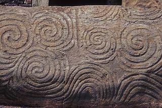
Megalithic art refers to art either painted or carved onto megaliths in prehistoric Europe. Elizabeth Shee Twohig has coined the term Megalithic art in her study of 'The Megalithic Art of Western Europe'. Her original definition of Megalithic art focused on paintings or carvings found on the structural elements, like the kerbstones, orthostats, or capstones of megalithic tombs, but recent investigations have included decorations on stelae and menhirs.

<span class="mw-page-title-main">Cup and ring mark</span> Form of prehistoric art

Cup and ring marks or cup marks are a form of prehistoric art found in the Atlantic seaboard of Europe (Ireland, Wales, Northern England, Scotland, France, Portugal, and Spain – and in Mediterranean Europe – Italy, Azerbaijan and Greece, as well as in Scandinavia and in Switzerland.

<span class="mw-page-title-main">Long Meg and Her Daughters</span> Neolithic stone circle near Penrith, England

Long Meg and Her Daughters is a Neolithic stone circle situated north-east of Penrith near Little Salkeld in Cumbria, North West England. One of around 1,300 stone circles in the British Isles and Brittany, it was constructed as a part of a megalithic tradition that emerged during Neolithic, and continued into the Early Bronze Age. The stone circle is the third widest in England, behind Avebury in Wiltshire, and only slightly smaller than Stanton Drew in Somerset.

<span class="mw-page-title-main">Little Meg</span> Archaeological site in Cumbria, England

Little Meg is a small circle of large kerb stones which probably surrounded a Bronze Age kerb cairn. It is close to the village of Langwathby to the north-east of Penrith in the English county of Cumbria and is 650 metres north-east of the more famous stone circle of Long Meg and Her Daughters. It forms part of a complex of stone circles and cairns around the Long Meg site that includes the circle at Glassonby, Old Parks, and other sites since lost.

<span class="mw-page-title-main">Entoptic phenomena (archaeology)</span>

In archaeology, the term entoptic phenomena relates to visual experiences derived from within the eye or brain. In this respect they differ slightly from the medical definition, which defines entoptic phenomena as only applying to sources within the eye, not the brain. To avoid this confusion, the term subjective visual phenomena is sometimes used. Entoptic was chosen by author David Lewis-Williams due to its origin from Greek meaning "coming from within".

<span class="mw-page-title-main">Bronze Age Britain</span> Period of British history from c. 2500 until c. 800 BC

Bronze Age Britain is an era of British history that spanned from c. 2500–2000 BC until c. 800 BC. Lasting for approximately 1,700 years, it was preceded by the era of Neolithic Britain and was in turn followed by the period of Iron Age Britain. Being categorised as the Bronze Age, it was marked by the use of copper and then bronze by the prehistoric Britons, who used such metals to fashion tools. Great Britain in the Bronze Age also saw the widespread adoption of agriculture.

<span class="mw-page-title-main">Rock Drawings in Valcamonica</span> Prehistoric petroglyph collection in Italy

The rock drawings in Valcamonica are located in the Province of Brescia, Italy, and constitute the largest collections of prehistoric petroglyphs in the world. The collection was recognized by UNESCO in 1979 and was Italy's first recognized World Heritage Site. UNESCO has formally recognized more than 140,000 figures and symbols, but new discoveries have increased the number of catalogued incisions to between 200,000 and 300,000. The petroglyphs are spread on all surfaces of the valley, but concentrated in the areas of Darfo Boario Terme, Capo di Ponte, Nadro, Cimbergo and Paspardo.

<span class="mw-page-title-main">Neolithic British Isles</span> British, Irish and Manx history c. 4100–2500 BCE

The Neolithic period in the British Isles lasted from c. 4000 to c. 2,500 BCE. Constituting the final stage of the Stone Age in the region, it was preceded by the Mesolithic and followed by the Bronze Age.

<span class="mw-page-title-main">Cathole Cave</span> Cave and archaeological site in Wales

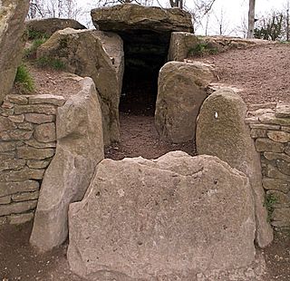
Cathole Cave, Cat Hole Cave or Cathole Rock Cave, is a cave near Parc Cwm long cairn at Parc le Breos, on the Gower Peninsula, Wales. It is a steep limestone outcrop, about 200 yards (180 m) north of the cromlech along the Parc le Breos Cwm valley and near the top of the gorge, about 50 feet (15 m) from the valley floor. The cave is a deep triangular fissure penetrating the hillside and narrowing towards the top. It has two entrances, with a natural platform outside the larger of the two. It is about seven 12 miles (12 km) west south–west of Swansea, Wales, in what is now known as Coed y Parc Cwm at Parc le Breos, on the Gower Peninsula.

<span class="mw-page-title-main">Stone circles in the British Isles and Brittany</span> Megalithic tradition of monuments

The stone circles in the British Isles and Brittany are a megalithic tradition of monuments consisting of standing stones arranged in rings. These were constructed from 3300 to 900 BCE in Britain, Ireland and Brittany. It has been estimated that around 4,000 of these monuments were originally constructed in this part of north-western Europe during this period. Around 1,300 of them are recorded, the others having been destroyed.

<span class="mw-page-title-main">Rock art of Europe</span>

Rock art has been produced in Europe since the Upper Palaeolithic period through to recent centuries. It is found in all of the major regions of the continent. One of the most famous examples of parietal art is the Grotte Chauvet in France. The cultural purpose of these remnants of the Paleolithic and other periods of prehistoric art is not known. However, some theories suggest that, because these paintings were created in parts of the caves that were not easily accessed, it is unlikely that they were intended simply as decoration.

<span class="mw-page-title-main">Architecture of Scotland in the prehistoric era</span> Buildings of Scotland in the Prehistoric era

The architecture of Scotland in the prehistoric era includes all human building within the modern borders of Scotland, before the arrival of the Romans in Britain in the first century BCE. Stone Age settlers began to build in wood in what is now Scotland from at least 8,000 years ago. The first permanent houses of stone were constructed around 6,000 years ago, as at Knap of Howar, Orkney and settlements like Skara Brae. There are also large numbers of chambered tombs and cairns from this era, particularly in the west and north. In the south and east there are earthen barrows, often linked to timber monuments of which only remnants remain. Related structures include bank barrows, cursus monuments, mortuary enclosures and timber halls. From the Bronze Age there are fewer new buildings, but there is evidence of crannogs, roundhouses built on artificial islands and of Clava cairns and the first hillforts. From the Iron Age there is evidence of substantial stone Atlantic roundhouses, which include broch towers, smaller duns. There is also evidence of about 1,000 hillforts in Scotland, most located below the Clyde-Forth line.

<i>The Significance of Monuments</i> Book by Richard Bradley

The Significance of Monuments: On the Shaping of Human Experience in Neolithic and Bronze Age Europe is an archaeological book authored by the English academic Richard Bradley of the University of Reading. It was first published by Routledge in 1998.

<span class="mw-page-title-main">Shap Stone Avenue</span> Neolithic stone complex in Cumbria, England

The Shap Stone Avenue is a megalithic complex near Shap in Cumbria, England, comprising stone circles, a two-mile avenue of stones, and burial mounds.

<span class="mw-page-title-main">Prehistoric art in Scotland</span> Overview and examples of prehistoric art in Scotland

Prehistoric art in Scotland is visual art created or found within the modern borders of Scotland, before the departure of the Romans from southern and central Britain in the early fifth century CE, which is usually seen as the beginning of the early historic or Medieval era. There is no clear definition of prehistoric art among scholars and objects that may involve creativity often lack a context that would allow them to be understood.

<i>Rock Art and the Prehistory of Atlantic Europe</i> Book by Richard Bradley

Rock Art and the Prehistory of Atlantic Europe: Signing the Land is an archaeological book authored by the English academic Richard Bradley of the University of Reading. It was first published by Routledge in 1997.

<span class="mw-page-title-main">Prehistoric Cumbria</span>

Prehistoric Cumbria describes the English county of Cumbria prior to the Romans Period. This includes the Mesolithic, Neolithic, Bronze Age, and Iron Age. As of 2010, 443 stone tools, 193 metal objects and 134 ceramic pots, have been unearthed in Cumbria. Likewise, various monuments, such as henges and stone circles, are widespread in the region. The survival of these monuments and objects has been influenced by processes such as the rise in sea levels on the west coast, erosion, deposition practices, industrial and agricultural development, and the changing interests and capabilities of antiquarians and archaeologists.

References

Footnotes

Bibliography

  • Beckensall, Stan (1999). British Prehistoric Rock Art. Stroud: Tempus. ISBN   978-1848686267.
  • Beckensall, Stan (2002). Prehistoric Rock Art in Cumbria: Landscapes and Monuments. Stroud: The History Press. ISBN   978-0752425269.
  • Beckensall, Stan (2005). The Prehistoric Rock Art of Kilmartin. Kilmartin House Trust. ISBN   978-0953367429.
  • Bradley, Richard (1997). Rock Art and the Prehistory of Atlantic Europe: Signing the Land. London and New York: Routledge. ISBN   978-0415165365.
  • Bradley, Richard (1998). "Daggers Drawn: depictions of Bronze Age weapons in Atlantic Europe". In Christopher Chippindale; Paul S.C. Taçon (eds.). The Archaeology of Rock-Art. Cambridge University Press. pp. 130–145. ISBN   978-0521576192.
  • Bradley, Richard; Chippindale, Christopher; Helskog, Knut (2001). "Post-Paleolithic Europe". In David S. Whitley (ed.). Handbook of Rock Art Research. Lanham: AltaMira Press. pp.  482–529. ISBN   978-0742502567.
  • Brown, Paul; Brown, Barbara (2008). Prehistoric Rock Art in the Northern Dales. Stroud: The History Press. ISBN   978-0752442464.
  • Dronfield, J.C. (1995). "Subjective vision and the source of Irish megalithic art". Antiquity. Vol. 69. The Antiquity Trust. pp. 539–549.
  • Dronfield, J.C. (1996). "Entering alternative realities: cognition, art and architecture in Irish passage tombs". Cambridge Archaeological Journal. Vol. 6. pp. 37–72.
  • Evans, Edward (2004). Archaeology from Art: Exploring the Interpretative Potential of British and Irish Neolithic Rock Art. Oxford: British Archaeological Reports. ISBN   978-1841713557.
  • Lewis-Williams, David; Dowson, T. (1993). "On vision and power in the Neolithic: Evidence from the decorated monuments". Current Anthropology. Vol. 34. pp. 55–65.
  • Lewis-Williams, David; Pearce, David (2005). Inside the Neolithic Mind: Consciousness, Cosmos and the Realm of the Gods. London: Thames and Hudson. ISBN   978-0500051382.
  • Mackie, E.W.; Davis, A. (1989). "New Light on Neolithic Rock Carving: The Petroglyphs at Greenland (Auchentorlie), Dunbartonshire". Glasgow Archaeological Journal. Vol. 15. pp. 125–155.
  • Nash, George (2007). "A Scattering of Images: The rock-art of southern Britain". In Aron Mazel; George Nash; Clive Waddington (eds.). Art as Metaphor: The Prehistoric Rock Art of Britain. Oxford: Archaeopress. ISBN   978-1905739165.
  • Saward, Abegael (2001). "The Rocky Valley Labyrinths" (PDF). Caerdroia: The Journal of Mazes and Labyrinths. Vol. 32. Labyrinthos. pp. 21–27.
  • Smith, Brian A.; Walker, Alan A. (2008). Rock Art and Ritual: Interpreting the Prehistoric Landscapes of the North York Moors. Stroud: The History Press. ISBN   978-0752446349.
  • Smith, Brian A.; Walker, Alan A. (2011). Rock Art and Ritual: Mindscapes of Prehistory. Stroud: Amberley. ISBN   978-1445601885.
  • Waddington, Clive (2007). "Neolithic rock-art in the British Isles: retrospect and prospect". In Aron Mazel; George Nash; Clive Waddington (eds.). Art as Metaphor: The Prehistoric Rock Art of Britain. Oxford: Archaeopress. pp. 49–68. ISBN   978-1905739165.