
Virginia City is a census-designated place (CDP) that is the county seat of Storey County, Nevada, and the largest community in the county. The city is a part of the Reno–Sparks Metropolitan Statistical Area.

The Virginia and Truckee Railroad is a privately owned historical heritage railroad, headquartered in Virginia City, Nevada. Its private and publicly owned route is 14 miles long. The railroad owns and uses the service mark "Queen of the Short Lines". The V&T Railroad runs up to seven trains per day, many in steam behind locomotive #29, a 2-8-0 Consolidation, or an ex-US Army GE 80-ton diesel from Virginia City, from Memorial Day until the end of October each year.
State Route 318 is a state highway in eastern Nevada. It is often used as a shortcut for long-distance traffic along U.S. Route 93, bypassing the longer and less direct route U.S. Route 93 follows between Ely and Crystal Springs. The highway was established in the 1930s as State Route 38 and State Route 38A, and was renumbered to SR 318 in 1976. At a total of 110.762 miles (178.254 km), it is the longest state route in Nevada. The road is used for open speed highway races twice a year.

Sierra Highway or El Camino Sierra is a road in Southern California, United States. El Camino Sierra refers to the full length of a trail formed in the 19th century, rebuilt as highways in the early 20th century, that ran from Los Angeles to Lake Tahoe following parts of modern State Route 14, U.S. Route 395 and State Route 89. Two portions of this road are currently signed as Sierra Highway. The first is an old alignment of SR 14/U.S. Route 6 from Los Angeles to Mojave. This road is also signed with the unusual designation of State Route 14U through the city of Santa Clarita. The second part signed as Sierra Highway is a portion of US 395 in Bishop.
Interstate 80 (I-80) traverses the northern portion of the U.S. state of Nevada. The freeway serves the Reno–Sparks metropolitan area and passes through the towns of Fernley, Lovelock, Winnemucca, Battle Mountain, Carlin, Elko, Wells and West Wendover on its way through the state.
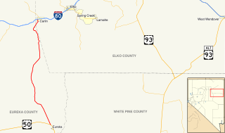
State Route 278 is a state highway in Nevada. It runs from U.S. Route 50 near Eureka north to Interstate 80 (I-80) in Carlin.
State Route 306 is a 30.631-mile (49.296 km) state highway in Lander and Eureka counties in northern Nevada, United States. It connects the mining area of Gold Acres in Lander County to Interstate 80 (I-80) at the Beowawe Interchange near Beowawe in Eureka County via Crescent Valley. The road has been a state highway since the 1920s, having been established as part of a much longer State Route 21 by 1929.

In the U.S. state of Nevada, U.S. Route 95 Alternate is an alternate route of U.S. Route 95 located in the western part of the state. It connects Schurz to Interstate 80 via the cities of Yerington and Fernley.
State Route 341 is a state highway in western Nevada connecting US 50 near Dayton to Reno via Virginia City. Commonly known as the Virginia City Highway, or Geiger Grade north of Virginia City, the route has origins dating back to the 1860s.
State Route 373 is a 16.304-mile-long (26.239 km) state highway in Nye County, Nevada, United States. It is a highway connecting California State Route 127 to U.S. Route 95, providing southern Nye County access to the eastern areas of Death Valley National Park.
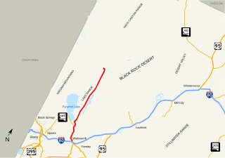
State Route 447 is a state highway in the U.S. state of Nevada. The highway is almost entirely within Washoe County but does for a brief time enter Pershing County, Nevada. The highway connects the town of Gerlach to the remainder of the state via Wadsworth. Though passing through extremely remote and desolate areas of Nevada, the highway has recently gained fame as the primary route to access the Black Rock Desert, the site of the annual Burning Man festival. The state maintained portion ends at Gerlach; however the highway continues as Washoe County Route 447 from Gerlach north to the California state line near Cedarville.
State Route 667 is a state highway in the Reno-Sparks metropolitan area of Washoe County, Nevada. It follows a portion of Kietzke Lane, a major north–south arterial in the area.

In the U.S. state of Nevada, U.S. Route 50 Alternate is an east–west alternate route of U.S. Route 50. The highway splits from US 50 in Silver Springs, heading north to Fernley and then southeast to rejoin US 50 west of Fallon. Over the years, the route has held several numerical highway designations.
State Route 398 is a state highway in Pershing County, Nevada serving the city of Lovelock. Part of the highway is former State Route 66.
State Route 774 is a 7.455-mile (11.998 km) state highway in Esmeralda County, Nevada, United States. It is known as Gold Point Road, connecting the town of Gold Point to State Route 266. The route was originally part of former State Route 71.
State Route 512 was a state highway in Carson City, Nevada. It connected Kings Canyon west of Carson City to the state capitol using various city streets. The route dates to the mid-19th century, as part of a wagon trail linking Lake Tahoe and Carson City that was later incorporated into the Lincoln Highway. SR 512 was turned over to local control in 2010.
State Route 425 is a 3.437-mile-long (5.531 km) state highway that serves the town of Verdi in Washoe County, Nevada. Interstate 80 Business is routed along the highway and extends beyond the terminus of the state route. SR 425 was formerly a part of SR 1 and U.S. Route 40.
U.S. Route 395 Business is a north–south state highway in Reno, Nevada. The highway follows Virginia Street, the primary north–south arterial street of the area. US 395 is also designated as State Route 430 (SR 430) from its intersection with SR 659 to its northern terminus at US 395.
State Route 427 is a 4.7-mile-long (7.6 km) state highway in the U.S. state of Nevada. It connects the community of Wadsworth in eastern Washoe County to the city of Fernley in western Lyon County. SR 427 comprises the former routing of U.S. Route 40 through the towns it serves. SR 427 also provides an eastern link to Pyramid Lake via a junction with State Route 447 in Wadsworth.
State Route 659 is a state highway in Washoe County, Nevada. The route follows McCarran Boulevard, an arterial ring road serving the cities of Reno and Sparks. The route provides access to many businesses and residential areas in the Truckee Meadows.


