New Barn

Last updated

New Barn
Kent UK location map.svg
Red pog.svg
New Barn
Location within Kent
Civil parish
District
Shire county
Region
Country England
Sovereign state United Kingdom
Post town LONGFIELD
Postcode district DA3
Dialling code 01474
Police Kent
Fire Kent
Ambulance South East Coast
UK Parliament
List of places
UK
England
Kent
51°23′44″N0°19′37″E / 51.395480°N 0.326980°E / 51.395480; 0.326980

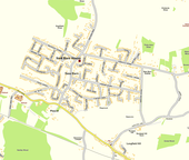
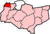
New Barn is a village in Kent, England. It is a compact residential area surrounded by open fields [1] which lies four miles southwest of Gravesend. It is in the local government district of Dartford. The villages of New Barn and Longfield are within and give their names to the civil parish of Longfield and New Barn. New Barn is larger in population than Longfield, although has little in the way of services, being a recent development and purely residential in nature

Contents

History

Historically New Barn was divided between the parishes of Southfleet, Longfield and Northfleet. The greater part was in the parish of Southfleet, including New Barn House, New Barn Road, Southfleet Avenue and the western sections of Longfield and Fawkham Avenues up to the parish boundary, which bisected these roads in a north–south direction. To the south, Southfleet parish extended up to Pescot Avenue, with the boundary running east–west. [2]

Southfleet and Longfield were both part of Dartford Rural District and prior to that the Hundred of Axstane. [3] Northfleet became an Urban District. Under the Local Government Act 1972, Southfleet, Longfield and Northfleet were allocated to the districts of Dartford, Sevenoaks and Gravesham respectively, but in 1987 New Barn was unified and transferred to the new parish of Longfield and New Barn within the borough of Dartford. [4]

In the centre of New Barn lies New Barn House, a 16th-century timber-framed building, which became a Grade II listed building in 1982. [5] On 19th century maps this was shown as New Barn Farm. [2] Much of the grounds (including the well) have been sold and developed as the residential cul-de-sac of Bentley Close.

New Barn Road as it passes the grounds of New Barn House (right) New Barn Road - geograph.org.uk - 326703.jpg
New Barn Road as it passes the grounds of New Barn House (right)

Parish Council

Longfield and New Barn is a Civil Parish within the Borough (or District) of Dartford. The Parish Council is made up of 4 wards with 12 Parish Councillors. New Barn West ward has 3 Councillors and New Barn East ward has 4 Councillors [6]

Ecclesiastic Parish

Most of New Barn lies in the ecclesiastic Parish of Southfleet, whose church is St. Nicholas Church in Southfleet. Only the part in the former parish of Longfield comes within Longfield for church purposes. [7]

Population

According to the Kent (District Boundaries) Order 1987 [8] the population of the part of New Barn formerly in Gravesham was 775, while the population of the part already in Dartford was 1,920. [9]

The boundary between New Barn and Longfield within the old parish of Longfield or the new parish of Longfield and New Barn was not defined. However the extent of the contiguous built up area of New Barn south of the former boundary, i.e. that part already in Longfield parish, can be seen on the Ordnance Survey map. [2] Also, the part of New Barn in Longfield parish was defined in the submission by Gravesham to the boundary review reported in the Local Government Boundary Commission For England Report No. 494, 28 February 1985 [10] This put the boundary along the centre of the B260 (Main Road Longfield) including within New Barn the roads Pescot Avenue, The Drive, Hill View Road and the new development at The Yews. The Gravesham scheme would include 18 per cent of the population of the old parish of Longfield, namely around 400. [11]

Thus the population of New Barn was around 3,100 at the time of the 1985 boundary review (previous Census 1981).

The last Census for which detailed local figures are available is 2001. [12] The census enumeration districts are not delimited such as to give an exact figure for New Barn. However the total for the parish, 4,866 in 2001, is roughly the same as when the parish was created. Therefore, it is likely that New Barn's population is still roughly 3,100. The allocation of parish councillors to the New Barn wards (7 out of 12) is consistent with this.

Topography

New Barn, Kent New Barn Kent map.png
New Barn, Kent

New Barn is on a hill, height 303 ft. on the north side of the dry valley of Longfield [13]

New Barn originates from a former landed estate, the New Barn Estate. It is compact residential area surrounded by open, mainly farming, type land and separated by open land from the village of Southfleet and from Longfield to the south-west; it is separated from Istead Rise to the north-east and Meopham to the south-east. [1]

As one walks along Main Road, Longfield (B260) in an easterly direction there is on the left a bare hillside escarpment with along the main road a ribbon of development also on that side and on the other (south) side Longfield School and its playing fields. About two-thirds of the way along the bare hillside stops and the hillside is covered by the development of The Drive, Pescot Avenue and Hill View Road and the new development at the Yews, which together form the part of New Barn previously in Longfield parish, while on the south side of the main road lie the other two schools and other development. The New Barn development at the top of the hill is clearly visible from Longfield School grounds, while Longfield School and the main village in the valley below is visible from the end of Pescot Avenue.

If one continues along Main Road one comes to the separate village of Longfield Hill, which is on rising ground and in effect closes this end of the valley. Here also the road and railway cross at the extreme eastern end of the Parish. Longfield Hill itself is an attractive small village with a village green, public house, one or two shops and a Mission Church.

The main access to the New Barn development is New Barn Road which runs up the escarpment and through the middle of New Barn. It then runs on to the end of the main New Barn development and comes to the long ribbon of mainly larger properties which the Ratepayers Association wanted added to the New Barn unification scheme, but remains in Southfleet parish. Here one is over the hill and the land and the road falls away to the Thames estuary and one has a very broad vista lying before one over parts of Northfleet and Swanscombe to the River, with the development of Istead Rise on a separate hill in the right foreground; there are a number of tall chimneys prominent in the landscape. The road continues down through the edge of the Parish of Southfleet into Northfleet and Gravesend. The ex-Gravesham part of New Barn lies along the east side of New Barn and is at much the same level as Longfield Hill.

Related Research Articles

<span class="mw-page-title-main">Borough of Dartford</span> Borough & Non-metropolitan district in England

The Borough of Dartford is a local government district in the north-west of the county of Kent, England. Its council is based in the town of Dartford. It is part of the contiguous London urban area. It borders the borough of Gravesham to the east, Sevenoaks District to the south, the London Borough of Bexley to the west, and the Thurrock unitary authority in Essex to the north, across the River Thames. The borough was formed on 1 April 1974 by the merger of the Municipal Borough of Dartford, the Swanscombe Urban District, and part of the Dartford Rural District. According to the 2011 Census, its population was 97,365.

<span class="mw-page-title-main">Gravesham</span> Borough & Non-metropolitan district in England

Gravesham is a local government district with borough status in north-west Kent, England. Its administrative centre and largest town is Gravesend, which was known as Gravesham in ancient times.

<span class="mw-page-title-main">Northfleet</span> Human settlement in England

Northfleet is a town in the borough of Gravesham in Kent, England. It is located immediately west of Gravesend, and on the border with the Borough of Dartford. Northfleet has its own railway station on the North Kent Line, just east of Ebbsfleet International railway station on the High Speed 1 line.

<span class="mw-page-title-main">Swanley</span> Human settlement in England

Swanley is a town and civil parish in the Sevenoaks District of Kent, England, 16 miles (26 km) southeast of central London, adjacent to the Greater London boundary and within the M25 motorway periphery. The population at the 2021 census was 17,826.

<span class="mw-page-title-main">Longfield</span> Village in the Borough of Dartford, Kent, England

Longfield is a village in the Borough of Dartford, Kent, England. It is located 6 miles south east of Dartford and the same distance south-west of Gravesend.

Southfleet is a small village and civil parish in the borough of Dartford in Kent, England. The village is located three miles southwest of Gravesend, while the parish includes within its boundaries the hamlets of Betsham and Westwood.

<span class="mw-page-title-main">Hartley, Sevenoaks</span> Human settlement in England

Hartley is a village and civil parish in the Sevenoaks district of Kent, England. It is located 7 miles (11 km) south west of Gravesend and the same distance south east of Dartford.

<span class="mw-page-title-main">Sevenoaks (UK Parliament constituency)</span>

Sevenoaks is a constituency represented in the House of Commons of the UK Parliament since 2019 by Laura Trott, a Conservative.

<span class="mw-page-title-main">Dartford (UK Parliament constituency)</span> UK Parliament constituency since 1885

Dartford is a constituency represented in the House of Commons of the UK Parliament since 2010 by Gareth Johnson of the Conservative Party. It is the longest bellwether constituency in the country: the party of the winning candidate has gone on to form the government at every UK general election since 1964. Candidates for the largest two parties nationally have polled first and second since 1923 in Dartford.

<span class="mw-page-title-main">Bean, Kent</span> Human settlement in England

Bean is a village and civil parish in the Borough of Dartford, Kent, England. It is located 4.4 miles south east of Dartford and 5.4 miles south west of Gravesend.

<span class="mw-page-title-main">Hextable</span> Human settlement in England

Hextable is a village and civil parish in the Sevenoaks District of Kent, England. It lies 2 miles (3.2 km) north of Swanley and 4 miles (6.4 km) south of Dartford.

<span class="mw-page-title-main">Fawkham</span> Human settlement in England

Fawkham is a village and civil parish in the Sevenoaks District of Kent, England. Fawkham is defined as a hamlet by Sevenoaks District Council, with a population of 429. Fawkham is a low density, linear settlement along the bottom of a dry chalk valley some 3 mi (5 km) in length, with secondary lanes intersecting. There is no discernible village centre, although clusters of buildings occur near the Church/junction with Castle Hill, and around the village green and public house at the junction with Fawkham Green Road. There are around 220 houses.

Dartford Rural District was a rural district with an area of 34,037 acres (138 km2) in the county of Kent, England. In 1971 it had a population of 64,561 and an electorate of 43,911. At dissolution it was the most populous rural district council in Kent, but had once been larger, having lost territory when Crayford Urban District was created in 1920, and Swanscombe Urban District in 1926.

Elections to Dartford Borough Council were held on 1 May 2003. The whole council was up for election on new boundaries, which reduced the total number of seats from 47 to 44. The election in Longfield, New Barn and Southfleet ward was postponed following the death of Bob Dunn, one of the Conservative candidates. The delayed election returned three Conservative councillors, increasing their number to 21.

<span class="mw-page-title-main">Sutton-at-Hone</span> Human settlement in England

Sutton-at-Hone is a village in the civil parish of Sutton-at-Hone and Hawley in the Borough of Dartford in Kent, England. It is located 3.5 miles south of Dartford & 3.6 miles north east of Swanley.

<span class="mw-page-title-main">Ridley, Kent</span> Human settlement in England

Ridley is a place and former civil parish, now in the parish of Ash-cum-Ridley, in the Sevenoaks district, in the county of Kent, England. It lies between Sevenoaks and Chatham..

<span class="mw-page-title-main">2009 Kent County Council election</span>

The Kent County Council election, 2009 was an election to all 84 seats on Kent County Council held on 2 May as part of the 2009 United Kingdom local elections. 84 councillors were elected from 72 electoral divisions, which returned either one or two county councillors each by first-past-the-post voting for a four-year term of office. The electoral divisions were the same as those used at the previous election in 2005. No elections were held in Medway, which is a unitary authority outside the area covered by the County Council.

<span class="mw-page-title-main">Axstane Hundred</span>

Axstane was a hundred in the county of Kent, England. The Hundred of Axstane lay south-east of Dartford and Wilmington Hundred. It is called Achestan in Domesday Book, but by the reign of Edward I it was called Axstane.

References

  1. 1 2 "The Local Government Boundary Commission For England Report No. 494, 28 February 1985 – extract, principally s. 137 on Topography" (PDF). Archived from the original (PDF) on 4 June 2012. Retrieved 20 September 2012.
  2. 1 2 3 "Southfleet CP/AP" . Retrieved 19 September 2012.
  3. "Axstane Hundred" . Retrieved 19 September 2012.
  4. "The Kent (District Boundaries) Order 1987". www.opsi.gov.uk. Retrieved 18 September 2012.
  5. "British Listed Buildings – New Barn House" . Retrieved 18 September 2012.
  6. Longfield and New Barn Parish Council web site
  7. "Church of England Parish Finder". Archived from the original on 22 February 2014. Retrieved 21 September 2012.
  8. "The Kent (District Boundaries) Order 1987 – see Note in Appendix". www.opsi.gov.uk. Retrieved 18 September 2012.
  9. Deducting the 2,240 transferred from Sevenoaks and the 775 transferred from Gravesham from the new parish total of 4,935
  10. "The Local Government Boundary Commission For England Report No. 494, 28 February 1985" (PDF). Archived from the original (PDF) on 4 June 2012. Retrieved 20 September 2012.
  11. 18% of the 2,240 transferred from Sevenoaks
  12. Census 2001. Area: Longfield and New Barn CP (Parish). Office for National Statistics.
  13. Ordnance Survey Map 1" to 1 mile, 1940 edition

Commons-logo.svg Media related to New Barn at Wikimedia Commons