
Powys is a county and preserved county in Wales. It is named after the Kingdom of Powys which was a Welsh successor state, petty kingdom and principality that emerged during the Middle Ages following the end of Roman rule in Britain.

The A44 is a major road in the United Kingdom that runs from Oxford in southern England to Aberystwyth in west Wales.

Kington is a market town, electoral ward and civil parish in Herefordshire, England. The ward had a population of 3,240, while the 2011 Census registered a population of 2,626.

New Radnor is a village in Powys, Wales, to the south of Radnor Forest, and was the county town of Radnorshire.

Presteigne is a town and community in Radnorshire, Powys, Wales on the south bank of the River Lugg. Formerly the county town of the historic county of Radnorshire, the town has, in common with several other towns close to the Wales-England border, assumed the motto, "Gateway to Wales". The border wraps around three sides of the town. Nearby towns are Kington, Herefordshire to the south and Knighton to the north, and surrounding villages include Norton and Stapleton. The town falls within the Diocese of Hereford. The community has a population of 2,710; the built-up area had a population of 2,056.

The Leominster Canal was an English canal which ran for just over 18 miles from Mamble to Leominster through 16 locks and a number of tunnels, some of which suffered engineering problems even before the canal opened. Originally the canal was part of a much more ambitious plan to run 46 miles from Stourport to Kington.

The Welsh Marches line, known historically as the North and West Route, is the railway line running from Newport in south-east Wales to Shrewsbury in the West Midlands region of England by way of Abergavenny, Hereford and Craven Arms and thence to Crewe via Whitchurch. The line thus links the south of Wales to north-west England via the Welsh Marches region, bypassing Birmingham. Through services from south-west Wales, Swansea and Cardiff to Manchester and from Cardiff to Wrexham, Chester, the north coast of Wales and Anglesey constitute the bulk of passenger operations on the route.

Ludlow railway station in Ludlow, Shropshire, England, lies on the Welsh Marches Line between Shrewsbury 27 miles 42 chains (44.3 km) to the north and Hereford. The station is on Station Drive, 1⁄2 mile (0.80 km) to the northeast of Ludlow town centre.

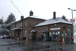
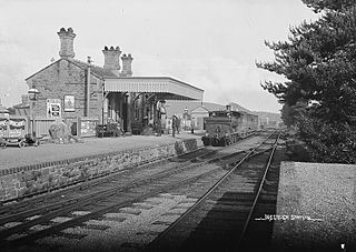
Leominster railway station lies on the Welsh Marches Line serving the Herefordshire town of Leominster in England. It is situated 11+1⁄4 miles (18.1 km) north of Hereford.
Abergavenny railway station is situated south-east of the town centre of Abergavenny, Wales. It is part of the British railway system owned by Network Rail and is operated by Transport for Wales. It lies on the Welsh Marches Line between Newport and Hereford.
Shobdon Aerodrome is an airport 6 NM west of Leominster, Herefordshire, England.
Hereford has seen a history of expansion and decline in its railway history.
The Shrewsbury and Hereford Railway was an English railway company that built a standard gauge line between those places. It opened its main line in 1853.
The Kington Tramway was an early narrow gauge horse-drawn tramway that linked limestone quarries at Burlinjobb near New Radnor in Radnorshire, Wales, to Eardisley in Herefordshire, England.
Leominster and Kington Railway was one of four branches which served the Welsh Marches border town of Kington, Herefordshire.
The Worcester, Bromyard and Leominster Railway was a 24.5-mile (39.4 km) single track branch railway line, that ran between a junction near Bransford Road on the West Midland Railway line south of Worcester to the Shrewsbury and Hereford Railway line south of Leominster.
The Kington and Eardisley Railway took over the Kington Tramway, which served the Welsh Marches border town of Kington, Herefordshire. In 1874 it opened a 6 miles 72 chains (11.1 km) line south from Titley Junction to a junction with the Hereford, Hay and Brecon Railway, 5 chains east of Eardisley. A year later it replaced the remainder of the tramway with a branch west to New Radnor. Between these two branches it had running powers on the Titley Junction to Kington section of the Leominster and Kington Railway. The Eardisley branch closed in 1940, the New Radnor branch in 1951.
Presteign Railway Station was a railway station serving the town of Presteigne, Radnorshire, Wales. It was a terminus on the Leominster and Kington Railway.
Forge Crossing Halt railway station was a station in Titley, Herefordshire, England. The station, on the Presteigne Branch Line of the Leominster and Kington Railway, was opened in 1929 and closed in 1951.
Ox House railway station was a station to the southwest of Shobdon, Herefordshire, England, close to Shobdon Aerodrome.

