New Richland, Minnesota

Last updated
New Richland
Motto(s): 
"History is ours, Future is yours."
Waseca County Minnesota Incorporated and Unincorporated areas New Richland Highlighted.svg
Location of New Richland, Minnesota
Detailed map of New Richland, Minnesota.png
Detailed map of New Richland, Minnesota
Coordinates: 43°53′40″N93°29′40″W / 43.89444°N 93.49444°W / 43.89444; -93.49444
Country Flag of the United States.svg  United States
State Flag of Minnesota.svg  Minnesota
County Waseca
Government
  TypeMayor - Council
  MayorMichael Shurson
Area
[1]
  Total0.59 sq mi (1.53 km2)
  Land0.59 sq mi (1.53 km2)
  Water0.00 sq mi (0.00 km2)
Elevation
[2]
1,188 ft (362 m)
Population
 (2020)
  Total1,229
  Density2,079.53/sq mi (802.92/km2)
Time zone UTC-6 (Central (CST))
  Summer (DST) UTC-5 (CDT)
ZIP code
56072
Area code 507
FIPS code 27-45862 [3]
GNIS feature ID2395213 [2]
Website City website

New Richland is a city in Waseca County, Minnesota, United States. The city was founded in 1877. The population was 1,203 at the 2010 census. [4]

Contents

History

New Richland was platted in 1877, taking its name from New Richland Township, which was named after Richland County, Wisconsin. [5] The city contains one property listed on the National Register of Historic Places, the 1902 New Richland Odd Fellows Hall. [6]

Geography

According to the United States Census Bureau, the city has an area of 0.61 square miles (1.58 km2), all land. [7] Minnesota Highways 13 and 30 are two of the main routes in the city.

Demographics

Historical population
CensusPop.Note
1880 304
1890 42339.1%
1900 75077.3%
1910 685−8.7%
1920 75410.1%
1930 7773.1%
1940 86311.1%
1950 9085.2%
1960 1,04615.2%
1970 1,1136.4%
1980 1,26313.5%
1990 1,237−2.1%
2000 1,197−3.2%
2010 1,2030.5%
2020 1,2292.2%
U.S. Decennial Census

2010 census

As of the census [8] of 2010, there were 1,203 people, 487 households, and 297 families living in the city. The population density was 1,972.1 inhabitants per square mile (761.4/km2). There were 531 housing units at an average density of 870.5 per square mile (336.1/km2). The racial makeup of the city was 97.1% White, 1.0% African American, 0.1% Native American, 0.2% Asian, 1.1% from other races, and 0.5% from two or more races. Hispanic or Latino of any race were 3.4% of the population.

There were 487 households, of which 29.0% had children under 18 living with them, 46.8% were married couples living together, 9.2% had a female householder with no husband present, 4.9% had a male householder with no wife present, and 39.0% were non-families. 33.3% of all households were made up of individuals, and 17.9% had someone living alone who was 65 or older. The average household size was 2.35 and the average family size was 3.01.

The median age in the city was 40.9 years. 24.3% of residents were under 18; 7% were between 18 and 24; 22.8% were from 25 to 44; 24.2% were from 45 to 64; and 21.8% were 65 or older. The gender makeup of the city was 49.0% male and 51.0% female.

2000 census

As of the census [3] of 2000, there were 1,197 people, 483 households, and 308 families living in the city. The population density was 2,002.8 inhabitants per square mile (773.3/km2). There were 503 housing units at an average density of 841.6 per square mile (324.9/km2). The racial makeup of the city was 99.08% White, 0.08% Asian, 0.33% from other races, and 0.50% from two or more races. Hispanic or Latino of any race were 1.17% of the population.

There were 483 households, of which 28.8% had children under 18 living with them, 50.9% were married couples living together, 9.1% had a female householder with no husband present, and 36.2% were non-families. 33.1% of all households were made up of individuals, and 20.5% had someone living alone who was 65 or older. The average household size was 2.34 and the average family size was 3.01.

In the city, the population was spread out, with 24.6% under 18, 5.8% from 18 to 24, 25.0% from 25 to 44, 18.8% from 45 to 64, and 25.7% who were 65 or older. The median age was 42. For every 100 females, there were 86.2 males. For every 100 females 18 and over, there were 79.0 males.

The median income for a household in the city was $36,406, and the median income for a family was $46,339. Males had a median income of $31,081 versus $22,500 for females. The per capita income was $18,106. About 2.3% of families and 4.7% of the population were below the poverty line, including 5.2% of those under 18 and 6.4% of those 65 or over.

Notable person

See also

Related Research Articles

<span class="mw-page-title-main">Richland, Michigan</span> Village in Michigan, United States

Richland is a village in Kalamazoo County in the U.S. state of Michigan. The population was 751 at the 2010 census, up from 593 at the 2000 census.

<span class="mw-page-title-main">Ramsey, Minnesota</span> City in Minnesota, United States

Ramsey is a suburb 22 miles north-northwest of downtown Minneapolis in Anoka County, Minnesota, United States. The population was 27,646 at the 2020 census. It is a northwest suburb of the Twin Cities.

<span class="mw-page-title-main">Backus, Minnesota</span> City in Minnesota, United States

Backus is a city in Cass County, Minnesota, United States. The population was 250 at the 2010 census. It is part of the Brainerd Micropolitan Statistical Area.

<span class="mw-page-title-main">Hampton, Minnesota</span> City in Minnesota, United States

Hampton is a city in Dakota County, Minnesota, United States. The population was 689 at the 2010 census.

<span class="mw-page-title-main">Glenville, Minnesota</span> City in Minnesota, United States

Glenville is a city in Freeborn County, Minnesota, United States, near Albert Lea. It is along the Shell Rock River. The population was 643 at the 2010 census.

<span class="mw-page-title-main">Wanamingo, Minnesota</span> City in Minnesota, United States

Wanamingo is a community in Goodhue County, Minnesota, United States, incorporated as a city. It lies along the North Fork of the Zumbro River. The population was 1,086 at the 2010 census.

<span class="mw-page-title-main">Deer Creek, Minnesota</span> City in Minnesota, United States

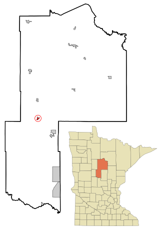
Deer Creek is a city in Otter Tail County, Minnesota, United States. The population was 330 at the 2020 census.

<span class="mw-page-title-main">Henning, Minnesota</span> City in Minnesota, United States

Henning is a city in Otter Tail County, Minnesota, United States. The population was 854 at the 2020 census.

Richland Township is a township in Rice County, Minnesota, United States. The population was 471 at the 2000 census. The unincorporated communities of Moland and Ruskin are both partially located within the township. The unincorporated community of Epsom is located within Richland Township.

<span class="mw-page-title-main">Orr, Minnesota</span> City in Minnesota, United States

Orr is a city in Saint Louis County, Minnesota, United States. The population was 211 at the 2020 census.

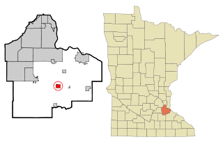
New Richland Township is a township in Waseca County, Minnesota, United States. The population was 497 at the 2000 census.

<span class="mw-page-title-main">Grant, Minnesota</span> City in Minnesota, United States

Grant is a city in Washington County, Minnesota, and a suburb of St. Paul. The population was 4,096 at the time of the 2010 census.

<span class="mw-page-title-main">Pine Springs, Minnesota</span> City in Minnesota, United States

Pine Springs is a city in Washington County, Minnesota, United States. The population was 408 at the 2010 census.

<span class="mw-page-title-main">Fairmount, North Dakota</span> City in Richland County, North Dakota, United States

Fairmount is a city in Richland County, North Dakota, United States. The population was 343 at the 2020 census. Fairmount was founded in 1884. It is part of the Wahpeton, ND–MN Micropolitan Statistical Area.

<span class="mw-page-title-main">Richland, Oregon</span> City in Oregon, United States

Richland is a city in Baker County, Oregon, United States. The population was 156 at the 2010 census.

<span class="mw-page-title-main">Motley, Minnesota</span> City in Minnesota, United States

Motley is a city in Cass and Morrison counties in the U.S. state of Minnesota. The population was 680 at the 2020 census. The main part of Motley is located within Morrison County; only a minor part of the city extends into Cass County

<span class="mw-page-title-main">Dennison, Minnesota</span> City in Minnesota, United States

Dennison is a city in Goodhue and Rice counties in the U.S. state of Minnesota. The population was 212 at the 2010 census. Most of Dennison is in Goodhue County, with only a small part that extends into Rice County.

<span class="mw-page-title-main">Eden Valley, Minnesota</span> City in Minnesota, United States

Eden Valley is a city in Meeker and Stearns counties in the U.S. state of Minnesota. The population was 1,042 at the 2010 census. Most of Eden Valley is in Meeker County; the Stearns County portion is part of the St. Cloud Metropolitan Statistical Area.

<span class="mw-page-title-main">Minneiska, Minnesota</span> City in Minnesota, United States

Minneiska is a city in Wabasha and Winona counties in the U.S. state of Minnesota. The population was 111 at the 2010 census.

<span class="mw-page-title-main">Richland, Iowa</span> City in Iowa, United States

Richland is a city in Keokuk County, Iowa, United States. The population was 542 at the time of the 2020 census.

References

  1. "2020 U.S. Gazetteer Files". United States Census Bureau. Retrieved July 24, 2022.
  2. 1 2 U.S. Geological Survey Geographic Names Information System: New Richland, Minnesota
  3. 1 2 "U.S. Census website". United States Census Bureau . Retrieved 2008-01-31.
  4. "2010 Census Redistricting Data (Public Law 94-171) Summary File". American FactFinder. United States Census Bureau . Retrieved 27 April 2011.[ dead link ]
  5. Upham, Warren (1920). Minnesota Geographic Names: Their Origin and Historic Significance. Minnesota Historical Society. p.  565.
  6. "Minnesota National Register Properties Database". Minnesota Historical Society. 2009. Retrieved 2018-01-01.
  7. "US Gazetteer files 2010". United States Census Bureau. Archived from the original on 2012-01-25. Retrieved 2012-11-13.
  8. "U.S. Census website". United States Census Bureau . Retrieved 2012-11-13.