
Jamaica is a neighborhood in the New York City borough of Queens. It is mainly composed of a large commercial and retail area, though part of the neighborhood is also residential. Jamaica is bordered by Hollis to the east; St. Albans, Springfield Gardens, Rochdale Village to the southeast; South Jamaica to the south; Richmond Hill and South Ozone Park to the west; Briarwood to the northwest; and Kew Gardens Hills, Jamaica Hills, and Jamaica Estates to the north.
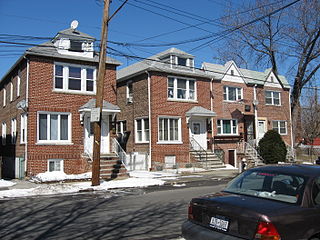
Pelham Bay is a middle class residential neighborhood in the borough of the Bronx, in New York City. It is named for Pelham Bay Park, New York City's largest park, which lies on the neighborhood's northeastern border; and for Pelham Bay, a body of water in that park. The neighborhood is bounded roughly by Pelham Parkway on the north, the New England Thruway (I-95) on the east, the Bruckner Expressway (I-95) on the south, and the Hutchinson River Parkway on the west.

Fordham Manor is a neighborhood located in the western Bronx, New York City. Fordham is roughly bordered by East 196th Street to the north, the Harlem River to the west, Fordham Road to the south, and Southern Boulevard to the east. The neighborhood's primary thoroughfares are Fordham Road and Grand Concourse.

Rodman's Neck refers to a peninsula of land in the New York City borough of the Bronx that juts out into Long Island Sound. The southern third of the peninsula is used as a firing range by the New York City Police Department; the remaining wooded section is part of Pelham Bay Park. The north side is joined to what used to be Hunters Island and Twin Island to form Orchard Beach and a parking lot.
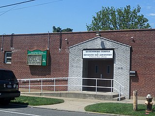
South Jamaica is a residential neighborhood in the borough of Queens in New York City, located south of downtown Jamaica. Although a proper border has not been established, the neighborhood is a subsection of greater Jamaica bounded by the Long Island Rail Road Main Line tracks, Jamaica Avenue, or Liberty Avenue to the north; the Van Wyck Expressway on the west; Rockaway Boulevard on the south; and Merrick Boulevard on the east, adjoining the neighboring community of St. Albans. Other primary thoroughfares of South Jamaica include Baisley, Foch, Linden, Guy R. Brewer, and Sutphin Boulevards. The 180th Street Business Improvement District is responsible for the development of the area.

University Heights is a neighborhood of the West Bronx in New York City. Its boundaries, starting from the north and moving clockwise, are: West Fordham Road to the north, Jerome Avenue to the east, West Burnside Avenue to the south and the Harlem River to the west. University Avenue is the primary thoroughfare in University Heights.

Parkchester is a planned community and neighborhood originally developed by the Metropolitan Life Insurance Company and located in the central Bronx, New York City. The immediate surrounding area also takes its name from the complex. Its boundaries, starting from the north and moving clockwise, are East Tremont Avenue to the north, Castle Hill Avenue to the east, Westchester Avenue to the south, East 177th Street/Cross Bronx Expressway to the southwest, and White Plains Road to the west. Metropolitan Avenue, Unionport Road, and White Plains Road are the primary thoroughfares through Parkchester.
Crime rates in New York City have been recorded since at least the 1800s. They have spiked ever since the post-war period. The highest crime totals were recorded in the late 1980s and early 1990s as the crack epidemic surged, and then declined continuously through the 2000s.
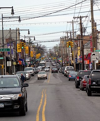
College Point is a working-middle-class neighborhood in the New York City borough of Queens. It is bounded to the south by Whitestone Expressway and Flushing; to the east by 138th Street and Malba/Whitestone; to the north by the East River; and to the west by Flushing Bay. College Point is a mostly residential ethnically diverse community with some industrial areas. The neighborhood is served by several parks and contains two yacht clubs.

Homecrest is a neighborhood situated in the New York City borough of Brooklyn, sometimes considered as part of Sheepshead Bay. It is bordered by Kings Highway to the north, Avenue X to the south, Coney Island Avenue to the west, and Ocean Avenue to the east.
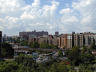
Morris Heights is a residential neighborhood located in the West Bronx. Its boundaries, starting from the north and moving clockwise are: West Burnside Avenue to the north, Jerome Avenue to the east, the Cross-Bronx Expressway to the south, and the Harlem River to the west. University Avenue is the primary thoroughfare through Morris Heights.

West Farms is a residential neighborhood in The Bronx, New York City. Its boundaries, are: Bronx Park to the north, the Bronx River Parkway to the east, the Cross-Bronx Expressway to the south, and Southern Boulevard to the west. East Tremont Avenue is the primary thoroughfare through West Farms.
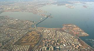
Bay Terrace is a neighborhood in the northeastern section of the New York City borough of Queens. It is often considered part of the larger area of Bayside. Bay Terrace overlooks the East River and the approaches to the Throgs Neck Bridge from the Clearview Expressway and Cross Island Parkway. It is bounded on the west by the Clearview Expressway, on the south by 26th and 28th Avenues, to the east by the Little Neck Bay, and to the north by the East River.

Flushing Airport is a decommissioned airfield in northern Queens in New York City. It is located in the neighborhood of College Point, near Flushing. The airfield was in operation from 1929 to 1984.

The Emergency Service Unit(ESU) is part of the Special Operations Bureau of the New York City Police Department. The unit provides specialized support and advanced equipment to other NYPD units. Members of ESU are cross-trained in multiple disciplines for police, first aid, and rescue work.

The New York City Police Department (NYPD) is structured into numerous bureaus and units. As a whole, the NYPD is headed by the Police Commissioner, a civilian administrator appointed by the Mayor, with the senior sworn uniformed officer of the service titled "Chief of Department". The Police Commissioner appoints the First Deputy Commissioner as the department's second-in-command and the Chief of Department as the department's highest ranking uniformed officer. The commissioner also appoints a number of deputy and assistant commissioners who do not have operational command and are solely for support and administrative function. The department is divided into twenty bureaus, six of which are enforcement bureaus. Each enforcement bureau is further subdivided into sections, divisions, and units, and into patrol boroughs, precincts, and detective squads. Each bureau is commanded by a bureau chief. There are also a number of specialized units that are not part of any of the bureaus and report to the Chief of the Department.

The shooting of Ramarley Graham took place in the borough of the Bronx in New York City on February 2, 2012. Richard Haste, a New York Police Department officer, shot Graham in the bathroom of the latter's apartment. The 18-year-old Graham was in possession of marijuana when Officer Haste tried to stop him on the street. Graham fled to his grandmother’s house, and went into the bathroom to flush the marijuana. Officer Haste forced his way into the building, kicked down the front door and then broke down the bathroom where he shot Ramarley Graham to death. Haste could be seen on surveillance cameras smiling and laughing with the responding officers and detectives—the same men who would later testify they had told Haste that Graham had a gun. Haste claimed to believe Graham had been reaching for a gun in his waistband, but no weapon was recovered.
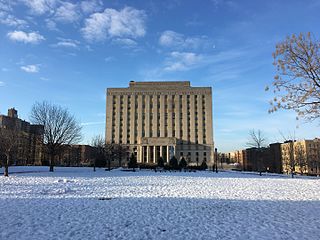
Concourse is a neighborhood in the southwestern section of the New York City borough of the Bronx which includes the Bronx County Courthouse, the Bronx Museum of the Arts, and Yankee Stadium. Its boundaries, starting from the north and moving clockwise, are East 169th Street to the north, Webster Avenue to the east, the Metro-North Railroad's Hudson Line to the south, and Jerome Avenue to the west. The neighborhood is divided into three subsections: West Concourse, East Concourse, and Concourse Village with the Grand Concourse being its main thoroughfare.
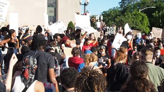
George Floyd protests in New York City took place at several sites in each of the five New York City boroughs, starting on May 28, 2020, in reaction to the murder of George Floyd. Most of the protests were peaceful, while some sites experienced protester and/or police violence, including several high-profile incidents of excessive force. Looting became a parallel issue, especially in Manhattan. As a result, and amid the COVID-19 pandemic, the city was placed under curfew from June 1–7, the first curfew in the city since 1943. The protests catalyzed efforts at police reform, leading to the criminalization of chokeholds during arrests, the repeal of 50-a, and other legislation. Several murals and memorials have been created around the city in George Floyd's honor, and demonstrations against racial violence and police brutality continued as part of the larger Black Lives Matter movement in New York City.


