1 Police Plaza

Last updated

One Police Plaza
NYPD Headquarters
NYPDHQNewYorkCityNY.jpg
1 Police Plaza in 2002
1 Police Plaza
Alternative names1PP
General information
Architectural style Brutalist
Location New York City, New York, U.S.
Coordinates 40°42′44″N74°00′06″W / 40.712204°N 74.001676°W / 40.712204; -74.001676
Current tenants New York City Police Department
Construction started1968
Completed1973
Inaugurated1979
Renovated1984
Cost$58 million
Owner City of New York
Technical details
Floor count14 (above ground)
Design and construction
Architecture firmGruzen & Partners
Main contractorCastagna & Sons

One Police Plaza (often abbreviated as 1PP) is the headquarters of the New York City Police Department (NYPD). The building is located on Park Row in Civic Center, Manhattan near New York City's City Hall and the Brooklyn Bridge. Its block borders Park Row, Pearl Street, and Police Plaza. 1PP replaced the NYPD's previous headquarters at 240 Centre Street, approximately 1 mile (1.6 km) north of 1 Police Plaza.

Contents

Description

The NYPD's previous headquarters, at 240 Centre Street between Broome and Grand Streets Broome St NYPD HQ 2008 jeh.jpg
The NYPD's previous headquarters, at 240 Centre Street between Broome and Grand Streets

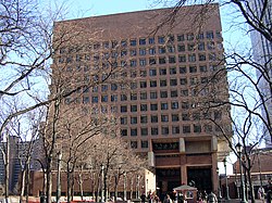
One Police Plaza is rectangular in plan and is an inverted pyramid in elevation. It is a 13-level, horizontally-oriented brutalist building designed by Gruzen and Partners. [1] A 22,000-square-foot (2,000 m2) expansion project was completed in 2011. Although the project did not add any new floors to the building, it did add new computers and equipment. Angry Lower Manhattan residents held a rally on August 27, 2008 near One Police Plaza to protest the addition, and tenants of three neighboring co-ops filed a lawsuit to force the NYPD to undergo environmental and land use reviews. [2]

Located on the second floor of One Police Plaza is the Real Time Crime Center, an anti-crime computer network which is essentially a large search engine and data warehouse operated by detectives to assist officers in the field with their investigations. The Major Case Squad and the Technical Assistance Response Unit (TARU) are also located at 1PP. [3]

Inside 1 Police Plaza, a room on the second floor affectionately called "The Shack" served as the police bureau office for local press outlets until 2024 when it was moved to a structure outside the building. [4] Its tenants include the Associated Press, the Daily News , New York Post , The New York Times , Newsday , Staten Island Advance , El Diario La Prensa , NY1 News, and WINS Radio. [5] Its police counterpart is on the 13th floor, the office of the Deputy Commissioner of Public Information (DCPI). Also inside 1PP is the "Thirteenth Floor", the office of the New York City Police Commissioner.

Park Row closure criticism

One Police Plaza showing Tony Rosenthal 5 in 1, 1973-74 (plop art) Cor-Ten Steel sculpture NYPD HQ.jpg
One Police Plaza showing Tony Rosenthal 5 in 1 , 1973–74 (plop art) Cor-Ten Steel sculpture

Park Row, historically a major artery linking the Financial District to Chinatown and the Bowery, has been closed to public traffic since 2001. [6] The NYPD asserts that this is necessary to protect its headquarters from a truck bomb attack. Chinatown residents were particularly frustrated at the disruption caused by the closure of the thoroughfare, especially nearby residents. People who live nearby argued that the police department had placed a chokehold on an entire neighborhood and that if One Police Plaza was such an obvious terrorist target, it should be moved from a residential area. [7] Members of the Civic Center Residents Coalition fought the security perimeter around One Police Plaza for years. Park Row reopened for foot traffic and MTA buses in 2005, [8] although only 200 buses per day were allowed on the street, and they had to pass through security checkpoints. [9]

In 2007, the NYPD stated that it would not be moving despite the numerous complaints from residents, explaining that they had tried to alleviate the impact of the security measures by forbidding officers from parking in nearby public spaces and by reopening a stairway that skirts the headquarters' south side and leads down to street level near the Brooklyn Bridge. The department also planned to redesign its guard booths and security barriers to make them more attractive, and was involved in efforts to convert two lanes of Park Row into a cycling and pedestrian greenway, [6] which opened in June 2018. [10]

Related Research Articles

<span class="mw-page-title-main">Battery Park City</span> Neighborhood of Manhattan in New York City

Battery Park City is a mainly residential 92-acre (37 ha) planned community and neighborhood on the west side of the southern tip of the island of Manhattan in New York City. It is bounded by the Hudson River on the west, the Hudson River shoreline on the north and south, and the West Side Highway on the east. The neighborhood is named for the Battery, formerly known as Battery Park, located directly to the south.

<span class="mw-page-title-main">Broadway (Manhattan)</span> Avenue in New York

Broadway is a road in the U.S. state of New York. Broadway runs from State Street at Bowling Green for 13 mi (20.9 km) through the borough of Manhattan, over the Broadway Bridge, and 2 mi (3.2 km) through the Bronx, exiting north from New York City to run an additional 18 mi (29.0 km) through the Westchester County municipalities of Yonkers, Hastings-On-Hudson, Dobbs Ferry, Irvington, Tarrytown, and Sleepy Hollow, after which the road continues, but is no longer called "Broadway". The latter portion of Broadway comprises a portion of U.S. Route 9.

Many closings and cancellations followed the September 11, 2001 attacks, including major landmarks, buildings, restrictions on access to Lower Manhattan, as well as postponement or cancellation of major sporting and other events. Landmarks were closed primarily because of fears that they may be attacked. At some places, streets leading up to the institutions were also closed. When they reopened, there was heightened security. Many U.S. states declared a state of emergency.

<span class="mw-page-title-main">Chinatown, Manhattan</span> Neighborhood in New York City

Manhattan's Chinatown is a neighborhood in Lower Manhattan, New York City, bordering the Lower East Side to its east, Little Italy to its north, Civic Center to its south, and Tribeca to its west. With an estimated population of 90,000 to 100,000 people, Chinatown is home to the highest concentration of Chinese people in the Western Hemisphere. Manhattan's Chinatown is also one of the oldest Chinese ethnic enclaves. The Manhattan Chinatown is one of nine Chinatown neighborhoods in New York City, as well as one of twelve in the New York metropolitan area, which contains the largest ethnic Chinese population outside of Asia, comprising an estimated 893,697 uniracial individuals as of 2017.

<span class="mw-page-title-main">Midtown Manhattan</span> Central business district in New York City

Midtown Manhattan is the central portion of the New York City borough of Manhattan and serves as the city's primary central business district. Midtown is home to some of the city's most prominent buildings, including the Empire State Building, the Chrysler Building, the Hudson Yards Redevelopment Project, the headquarters of the United Nations, Grand Central Terminal, and Rockefeller Center, as well as several prominent tourist destinations including Broadway, Times Square, and Koreatown. Penn Station in Midtown Manhattan is the busiest transportation hub in the Western Hemisphere.

<span class="mw-page-title-main">Park Avenue</span> North–south avenue in Manhattan and the Bronx, New York

Park Avenue is a boulevard in New York City that carries north and southbound traffic in the boroughs of Manhattan and the Bronx. For most of the road's length in Manhattan, it runs parallel to Madison Avenue to the west and Lexington Avenue to the east. Park Avenue's entire length was formerly called Fourth Avenue; the title still applies to the section between Cooper Square and 14th Street. The avenue is called Union Square East between 14th and 17th Streets, and Park Avenue South between 17th and 32nd Streets.

<span class="mw-page-title-main">Chinatown, Oakland, California</span> Neighborhood of Oakland in Alameda, California, United States

The Chinatown neighborhood in Oakland, California, is traditionally Chinese which reflects Oakland's diverse Chinese American, and more broadly Asian American community. It is frequently referred to as "Oakland Chinatown" in order to distinguish it from nearby San Francisco's Chinatown. It lies at an elevation of 39 feet.

<span class="mw-page-title-main">Center City, Philadelphia</span> Neighborhood in Philadelphia, Pennsylvania

Center City includes the central business district and central neighborhoods of Philadelphia, Pennsylvania, United States. It comprises the area that made up the City of Philadelphia prior to the Act of Consolidation, 1854, which extended the city borders to be coterminous with Philadelphia County.

<span class="mw-page-title-main">One Liberty Plaza</span> Office skyscraper in Manhattan, New York

One Liberty Plaza, formerly the U.S. Steel Building, is a skyscraper in the Financial District of Lower Manhattan in New York City. It is situated on a block bounded by Broadway, Liberty Street, Church Street, and Cortlandt Street, on the sites of the former Singer Building and City Investing Building.

<span class="mw-page-title-main">Park Row (Manhattan)</span> Street in Manhattan, New York

Park Row is a street located in the Financial District, Civic Center, and Chinatown neighborhoods of the New York City borough of Manhattan. The street runs east-west, sometimes called north-south because the western end is nearer to the Financial District. At the north end of Park Row is the confluence of Bowery, East Broadway, St. James Place, Oliver Street, Mott Street, and Worth Street at Chatham Square. At the street's south end, Broadway, Vesey Street, Barclay Street, and Ann Street intersect. The intersection includes a bus turnaround loop designated as Millennium Park.

<span class="mw-page-title-main">Downtown (Washington, D.C.)</span> United States historic place

Downtown is the central business district of Washington, D.C., located in Northwest D.C. It is the third largest central business district in the United States. The "Traditional Downtown" has been defined as an area roughly between Union Station in the east and 16th Street NW in the west, and between the National Mall on the south and Massachusetts Avenue on the north, including Penn Quarter. However, nowadays, Downtown D.C. usually refers to a larger area, as the DC Office of Planning states:

…most residents, workers, and visitors think of Downtown in a broader sense — including areas as far north as Dupont Circle, as far west as Foggy Bottom, and as far east as Capitol Hill. Only about half of the central city workforce is located within the city’s traditional Downtown.

<span class="mw-page-title-main">Centre Street (Manhattan)</span> Street in Manhattan, New York

Centre Street is a north–south street in the New York City borough of Manhattan, running through the Civic Center, Chinatown, and Little Italy neighborhoods of Lower Manhattan. It connects Park Row to the south with Spring Street to the north, where it merges with Lafayette Street. Centre Street carries northbound traffic north of Reade Street and two-way traffic between Reade Street and the Brooklyn Bridge.

<span class="mw-page-title-main">Chambers Street (Manhattan)</span> Street in Manhattan, New York

Chambers Street is a two-way street in the New York City borough of Manhattan. It runs from River Terrace, Battery Park City in the west, past PS 234, The Borough of Manhattan Community College, and Stuyvesant High School, to the Manhattan Municipal Building at 1 Centre Street in the east. Between Broadway and Centre Street, Chambers Street forms the northern boundary of the grounds surrounding New York City Hall and the Tweed Courthouse. Opposite the Tweed Courthouse sits the Surrogate's Courthouse for Manhattan. 280 Broadway the Marble Palace, lies west of there, on the north side of Chambers.

<span class="mw-page-title-main">Washington Street (Manhattan)</span> Street in Manhattan, New York

Washington Street is a north–south street in the New York City borough of Manhattan. It runs in several distinct pieces, from its northernmost end at 14th Street in the Meatpacking District to its southern end at Battery Place in Battery Park City. Washington Street is, for most of its length, the westernmost street in lower Manhattan other than West Street. The exceptions are a one-block segment in the West Village where Weehawken Street lies between West and Washington Streets, and in Battery Park City.

<span class="mw-page-title-main">Allen Street</span> Street in Manhattan, New York

Allen Street is a street in the New York City borough of Manhattan which runs north-south through the Lower Manhattan neighborhood of Chinatown and the Lower East Side. It is continued north of Houston Street as First Avenue. South of Division Street, it is known as Pike Street to its southern terminus at South Street. The northbound and southbound roadways are separated by a meridian mall, which has two bike lanes located outside the meridian mall; each bike lane is unidirectional. The street's namesake was Master Commandant William Henry Allen, the youngest person to command a Navy ship in the War of 1812. He was killed in action at the age of 28. His exploits included the capture of the British ship HMS Macedonian.

<span class="mw-page-title-main">Stockton Street (San Francisco)</span> Street in San Francisco, California, US

Stockton Street is a north-south street in San Francisco. It begins at Market Street passing Union Square, a major shopping district in the city. It then runs underground for about two and a half blocks in the Stockton Street Tunnel, passes through Chinatown and North Beach, and ends at Beach Street near the Pier 39 shopping center and tourist attraction.

<span class="mw-page-title-main">55 Water Street</span> Office skyscraper in Manhattan, New York

55 Water Street is a 687-foot-tall (209 m) skyscraper on the East River in the Financial District of Lower Manhattan, New York City, United States. The 53-story, 3.5-million-square-foot (325,000 m2) structure was completed in 1972. Designed by Emery Roth and Sons, the building was developed by the Uris brothers. At the time of completion, it was the world's largest privately owned office building by floor area. 55 Water Street is built on a superblock bounded by Coenties Slip to the southwest, Water Street to the northwest, Old Slip to the northeast, and South Street and FDR Drive to the southeast. It is owned by the pension fund Retirement Systems of Alabama (RSA).

The Shack is the nickname used by reporters for the structure where police reporters cover crime in New York City. In most cities, such a bureau is nicknamed a "cop shop." It is named after a cramped office which was located inside the NYPD headquarters, where journalists report on crime stories.

<span class="mw-page-title-main">Frederick Douglass Circle</span> Circle in Manhattan, New York

Frederick Douglass Circle is a traffic circle located at the northwest corner of Central Park at the intersection of Eighth Avenue and 110th Street in the New York City borough of Manhattan. The traffic circle is named for the American abolitionist, women's suffragist, editor, orator, author, statesman, and reformer Frederick Douglass.

<span class="mw-page-title-main">Plaza Lacson</span> Public square in Santa Cruz, Manila, Philippines

Plaza Lacson, also known by its old name, Plaza (de) Goiti, is a public square in Santa Cruz, Manila. It is bounded by Plaza Santa Cruz Road and Escolta Street to the west, Carlos Palanca Street to the south, and Carriedo Street to the east. Although the plaza is not considered the center of Santa Cruz, as it is located behind the Santa Cruz Church rather than in front of it, the plaza is considered to be one of the most important squares in Manila.

References

  1. "NYC Police Headquarters".
  2. "Lower Manhattan Residents Rally Against NYPD". Archived from the original on September 5, 2008. Retrieved December 1, 2008.
  3. Fahim, Kareem (July 15, 2005). "Center Gives Police High-Tech Help". The New York Times. Retrieved June 29, 2016.
  4. Klein, Charlotte (December 14, 2023). ""A Slippery Slope": NYPD Is Relocating Reporters From Police HQ to a Trailer". Vanity Fair. Retrieved January 12, 2024.
  5. Moore, Tina. "Welcome to The Shack, our new blog from inside NYPD headquarters at One Police Plaza". The Shack. Daily News. New York. Retrieved June 29, 2016.
  6. 1 2 Buckley, Cara (September 24, 2007). "Chinatown Residents Frustrated Over Street Closed Since 9/11". The New York Times.
  7. Dave Hogarty (September 24, 2007). "Park Row Paralysis". Gothamist. Archived from the original on May 21, 2011. Retrieved March 16, 2011.
  8. Rutenberg, Jim (April 15, 2005). "Park Row Is to Be Reopened To Pedestrian and Bus Traffic". The New York Times. ISSN   0362-4331 . Retrieved September 24, 2022.
  9. Wilson, Michael (May 16, 2005). "Metro Briefing | New York: Manhattan: Park Row Reopened To Buses". The New York Times. ISSN   0362-4331 . Retrieved September 24, 2022.
  10. Spivack, Carol (June 22, 2018). "park-row-bike-pedestrian-paths-reopens-after-9-11-closure". patch . Retrieved July 3, 2018.